 |
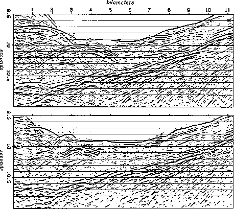
Figure 10 Top is 11 kilometers of reflection data from a survey line across the Japan trench (Tokyo University Oceanographic Research Institute). Bottom shows the result of migration processing. (Ottolini)
Plate tectonic theory says the ocean floors are made of thin plates that are formed at volcanic ridges near the middle of the oceans. These plates move toward trenches in the deepest part of the ocean where they plunge back down into the earth. The best evidence for the theory is the lack of old rocks on the floors of the earth's oceans. Generally, continents are older rocks jostled by the younger moving oceanic plates. The formation of plates by mid-ocean ridge volcanism is readily observed in a variety of ways. Whether the plates really do plunge at the trenches is not so clear observationally. The evidence comes from earthquake locations and from reflection seismology. Figure 9 shows some reflection data from the Japan trench.
 |
Two reflections dominate, the sea floor reflection and a deeper layer dipping down to the left. This latter is presumably the top part of a plate that is beginning its descent into the earth. We can examine it for evidence of bending downward, such as tension fractures near the surface. (The topmost layer is soft recent marine sediment loosely attached to the plate). Notice that the top of the plot is not zero time. The time axis runs from 9.5 to 11.0 seconds. Before 9.5 sec there are no echoes--we are waiting for the waves to go between the ship and the ocean floor. Hyperbolic reflections around kilometers 1-3 are collapsed by migration to form interesting ``blocky'' shapes. Look at the sea floor topography near kilometer 8 and the difference between migrated and unmigrated data sections. After migration, the sea floor diffraction hyperbolas move away from the plate echo (kilometer 4). Fractures (especially the one at 6.2 km) are more sharply defined. Finally, if the plate bends downward, it is not apparent from the data given. The bending question really requires a more detailed analysis of lateral variation in seismic velocity.
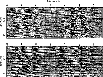
For an example with petroleum interest, see Figure 10, data from offshore Texas.
 |
Sediments are dropped where coastal rivers enter the Gulf of Mexico. The added weight causes slumping along steep faults. After a permeable sandstone layer has been identified by drilling, its reflection can be extrapolated up dip to the nearest fault on data like Figure 10. The fault is likely to break the continuity of the permeability trapping the upward flowing hydrocarbons. A sandstone at this depth can have a porosity of 25%. Assume a seismic velocity of 2.2 km/sec. Deduce the scale between physical volume and the data in Figure 10. Comparing the value of a volume of oil to the size of that same volume on Figure 10, you can see the importance of good images.
 |