


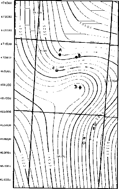
In October 1995, Pathfinder Oil and Gas, Inc., made available to me a portion of a 3-D land data set. The original prestack data set was recorded on an irregular, 17.5 square-mile grid. The sampling rate in time is 2 milliseconds over a 3 second total time recorded. There are 65 wells drilled on the site of the survey. The available data set comprises a poststack time-migrated 3-D seismic cube (3.6 squared miles) and six sets of well-log curves recorded at six different locations on the survey site. Figure 4 shows the interval velocity map for a particular horizon of the survey and the six well locations. The two southern wells (E and F) are dry holes.
 |

As of the date of this article, I have not received the corresponding 3-D prestack shot gathers and the stacking velocity model used to migrate the seismic data. I will also obtain four more well logs. The well-log curves available are two sonic logs, six gamma ray logs, as well as other curves (induction, self-potential, porosity, and density). No checkshots have been recorded in any of these wells.
The geology for the area is not structurally complex: at the depth of the target zone, the geology shows prograding carbonates and clastic sediments embedded in thin sand layers in a shaly environment. The prograding of the carbonated series makes it difficult to predict the extent of the oil reservoir reached by the four northern wells. Several dry holes have been drilled already in this area because of the inaccuracy of the velocity model used for the time-to-depth conversion.
For this data set I worked with the six well-log curves available.
I blocked by hand all
the gamma ray curves in order to do visual correlations between the various
wells. I defined nine major interfaces on one curve and retrieved them on the
five other curves. These interfaces bound regions of the curve where the gamma
ray values are roughly constant (high-frequency oscillations around a mean
value). I also blocked by hand the two sonic curves and retrieved the same nine
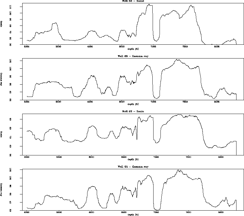
interfaces as determined on the gamma ray. Figure 5 shows a
portion of the sonic and gamma ray curves around the target zone.
The high-frequency component of the original logs has been removed by median
filtering on a running window. The four curves present strong similarities
exploitable for interpretation and visual correlations.
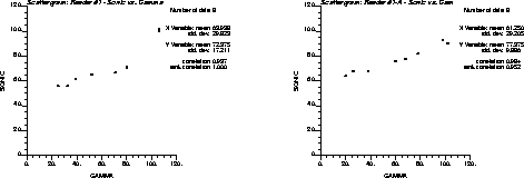
I then plotted several scattergrams
showing the existence of a correlation between the sonic and the gamma ray
curves at the two wells where both pieces of information were available. I
also observed a strong correlation (![]() ) between the
blocked sonic and the gamma ray logs. Figure 6 shows this
correlation on two
scattergrams of sonic median filtered values plotted against gamma ray median
filtered values for the nine layers defined around the target zone.
) between the
blocked sonic and the gamma ray logs. Figure 6 shows this
correlation on two
scattergrams of sonic median filtered values plotted against gamma ray median
filtered values for the nine layers defined around the target zone.
 |
 |