


At the beginning of 1995, John Toldi from Chevron Research Laboratory in La Habra provided SEP with a sample of data extracted from a data set. The sample data comprise a series of isovelocity (average velocity) surfaces and a set of well data points. The surfaces are isovelocity maps extracted from a 3-D root mean-squared (RMS) velocity cube and converted into average velocity maps. These maps give the depth to a particular velocity (e.g., 2000 m/s) at different locations. The well data points give the depth at the well location where the same isovelocity surface has been observed. These well velocity values were calculated from checkshots. Both kinds of data were available as GOCAD surfaces. GOCAD Mallet (1994) is a software package that offers numerous tools for building, viewing, and manipulating geologic models described as surfaces. Figure 1 represents a plane view of the 2000 m/s seismic isovelocity map. The black squares correspond to the location of the well data values for the same isovelocity surfaces.

The ultimate goal of this study is the depth conversion of the original seismic data. The well-derived velocities represent an accurate, but poorly sampled, data set. The seismic velocity is much denser, but less accurate. The velocity at the well is a measurement (high resolution, one sample per foot) while the seismic velocity is derived by calculations relying on the seismic two-way traveltime. Also, the conventional processing of the seismic data does not account for anisotropy. The stacking slowness (inverse of the velocity) depends on the traveltime, which depends on the physical interval slowness. Therefore, any uncertainty regarding the interval slowness or traveltime will have an effect on the stacking slowness estimation. The seismic stacking velocity also has a bias as a depth predicter; that is, there is a systematic mistie between the seismic and the well data sets. My goal is to cancel or at least significantly reduce this mistie.
Prior to receiving this data set, I studied an identical problem with a synthetic data example Berlioux (1995). The approach I took was to address this problem with a least-squares inversion scheme defined with the following set of equations:
| |
(3) |
The first equation of (3) performs a mapping of the well data
dw by linear interpolation, L being the linear interpolation operator,
onto the model space m. The second equation of (3) describes the
minimization of the error between the model and the linearly interpolated
seismic data as an initial version of the model. The scaling factor
![]() sets the relative importance of the well data over the seismic
data. I use a PEF determined from the seismic data for the roughening
operator A.
sets the relative importance of the well data over the seismic
data. I use a PEF determined from the seismic data for the roughening
operator A.
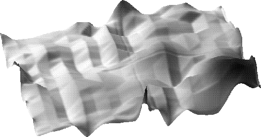
I solved the system of equations (3) by a conjugate gradient (CG) method. The CG approach produced good results for a synthetic example made of one isovelocity surface and four well data values. However, the same set of equations and the CG method did not produce conclusive results when applied to the Chevron data set. Figure 2 shows the 2000 m/s isovelocity surface after 1000 iterations of CG with a 5x5 PEF. High spikes are clearly visible around the well locations, and the depth to the surface is modified at the edge of the top right and lower left corner zones where no seismic data is available. I reduced the data set by extracting a portion of the same isovelocity map. These new data do not have the same disadvantages of the previews map, i.e., there is no jump at the edges to a zero value. Figure 3 shows the result of 1000 iterations of CG with a 5x5 PEF using the reduced data set. The resulting map is very smooth and follows the trend of the original seismic data. The misties at the well have been significantly reduced in general and cancelled for more than half the wells.
 |