


The first test dataset contains rainfall measurements from Switzerland
on the 8th of May 1986. The dataset was used in the Spatial
Interpolation Comparison () for comparing different spatial
interpolation methods. Figure 15 shows the data area: the
Digital Elevation Model of Switzerland and the country's
borders![[*]](http://sepwww.stanford.edu/latex2html/foot_motif.gif) . A total of 467
rainfall measurements were taken. A subset of randomly selected 100
measurements was used in the 1997 Spatial Interpolation Comparison in
order to compare the results with the known data.
Figure 16 shows the spatial location of the selected
data samples.
. A total of 467
rainfall measurements were taken. A subset of randomly selected 100
measurements was used in the 1997 Spatial Interpolation Comparison in
order to compare the results with the known data.
Figure 16 shows the spatial location of the selected
data samples.
|
elev
Figure 15 Digital Elevation Model of Switzerland and the country's borders. The country borders are extracted from the Digital Chart of the World (DCW) provided by ESRI. | 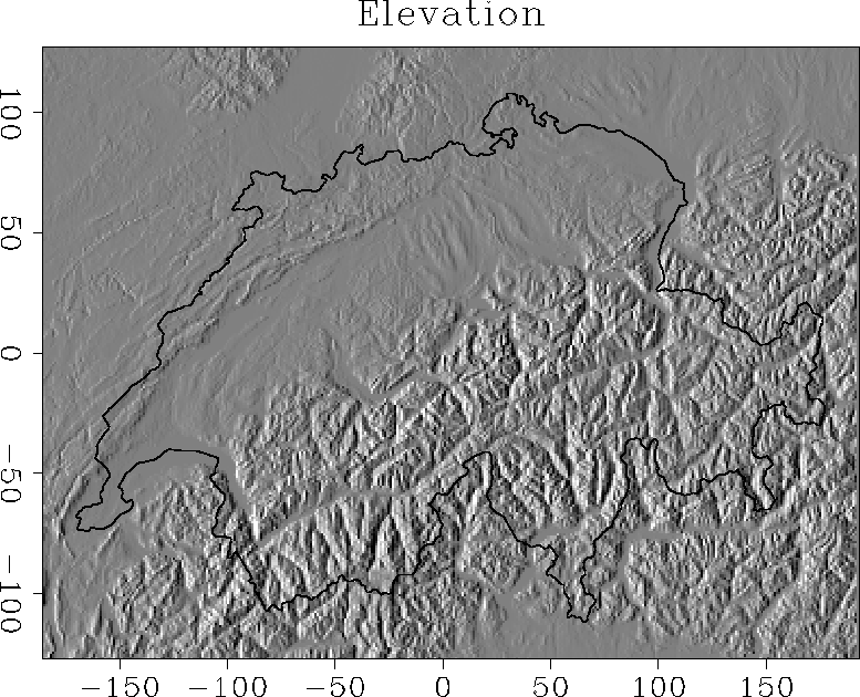 |


 |
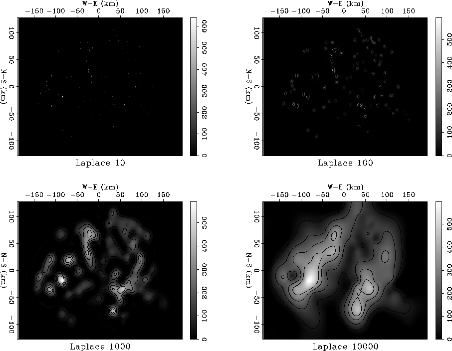
Rainfall level is generally a smoothly varying quantity. We cannot
expect it to be represented a priori by a simple function. Therefore,
it is reasonable to take the regularization operator ![]() to be
a convolution with the Laplacian filter. The corresponding
preconditioning operator
to be
a convolution with the Laplacian filter. The corresponding
preconditioning operator ![]() is then a deconvolution with the
minimum-phase Laplacian constructed in the previous section. The
interpolation result using the model-space regularization
scheme (
is then a deconvolution with the
minimum-phase Laplacian constructed in the previous section. The
interpolation result using the model-space regularization
scheme (![[*]](http://sepwww.stanford.edu/latex2html/cross_ref_motif.gif) -) is shown in
Figure 17. The input irregular data were regularized
on a 376 by 253 grid, which corresponds to the digital elevation model
in Figure 15. Similarly to what happens in the
one-dimensional synthetic examples, the solution converges steadily
but with a slow spread of information away from the known data points.
It takes about 10,000 iterations to achieve full convergence.
Figure 18 is a correlation plot of the observed and
interpolated data points for the 367 points that were not used in the
interpolation experiment. If we take into account the fairly
unpredictable distribution of rainfall, the correlation is relatively
good in comparison with analogous results of the Spatial Interpolation
Contest ().
-) is shown in
Figure 17. The input irregular data were regularized
on a 376 by 253 grid, which corresponds to the digital elevation model
in Figure 15. Similarly to what happens in the
one-dimensional synthetic examples, the solution converges steadily
but with a slow spread of information away from the known data points.
It takes about 10,000 iterations to achieve full convergence.
Figure 18 is a correlation plot of the observed and
interpolated data points for the 367 points that were not used in the
interpolation experiment. If we take into account the fairly
unpredictable distribution of rainfall, the correlation is relatively
good in comparison with analogous results of the Spatial Interpolation
Contest ().
 |
|
lapstat
Figure 18 Correlation between observed and predicted rainfall data values. | 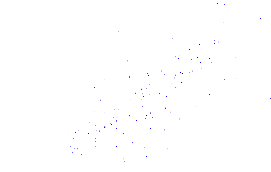 |
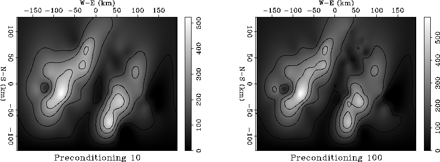
The result of applying recursive filter preconditioning with the minimum-phase Laplacian operator is shown in Figure 19. Full convergence is achieved after only 100 iterations. The result after 10 iterations (the left plot in Figure 19) is already close to the final solution. Recursive preconditioning speeded up the iteration count by a factor of 1000. The actual gain in execution time is several times smaller because of the correspondingly longer filter, but it is still impressively large.
 |