

![[*]](http://sepwww.stanford.edu/latex2html/prev_gr.gif)


ABSTRACTIn seismic images, the opaque oscillatory nature of the ever present sedimentary layers often hide the boundaries between sedimentary packages, such as faults or river channels. Interpreters painstakingly identify these boundaries by inspecting individual planes of the image volume. Discontinuity attribute maps computed from image volumes depict these boundaries and greatly simplify and accelerate seismic image interpretation. Standard edge enhancement fails to compute useful discontinuity maps, since the layers within a sedimentary package show similar rapid amplitude changes as the sought after package boundaries. Instead, the correlation of a local image region - patch - and its best-fitting plane wave delineates discontinuities that are characterized by a very rapid, pixel-to-pixel change in amplitude. The correlation attribute fails to delineate comparatively smooth discontinuities such as fault zones or fault reflections. Finally, locally estimated prediction-error filters fail to distinguish discontinuities and other image features. A prediction-error filter predicts and removes nearly all features in a migrated seismic image volume. Both, the misfit of a local plane wave and the prediction error only indicate if a given local image region contains a discontinuity or not. Consequently, the resolution of both approaches is limited to the size of the local image patch, which itself is somewhat arbitrary but subject to limiting tradeoffs. Future development ought to lead to a more fundamental classification of seismic image features. Discontinuity maps are only a special case of a potential automatic interpretation system. |
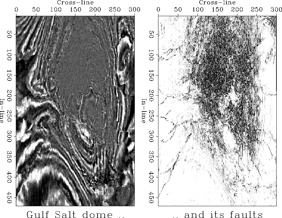
In the following chapters, I compare several methods to compute discontinuity attribute maps from seismic image volumes. These discontinuity maps aim to delineate boundaries of sedimentary packages, such as fault planes, river channels, and salt flanks. Discontinuities maps accelerate and improve the structural interpretation of traditional seismic image volumes. Figure 1 shows a time slice of a Gulf salt dome image and a corresponding discontinuity image - incidently my best result. In this chapter, I introduce the detection of seismic discontinuities by mentioning related publications, discussing the causes of seismic image discontinuities, outlining the investigations of the subsequent chapters, and presenting the three test cases that I use in this study.
 |


