


The synthetic example is based on a field data set from the Gulf of Mexico.
A well was drilled on location which hit gas,
and was logged for sonic velocity and density.
The reservoir level is at about 2.960 km depth, and the reservoir sand
dips 5![]() -10
-10![]() . The target zone chosen to perform
the Kirchhoff elastic prestack depth migration/inversion is a 2x2 km image
area, which is 1.75-3.75 km in depth (1.5-3.0 seconds on the stacked
time section).
. The target zone chosen to perform
the Kirchhoff elastic prestack depth migration/inversion is a 2x2 km image
area, which is 1.75-3.75 km in depth (1.5-3.0 seconds on the stacked
time section).
A synthetic shot gather was calculated based on a 1-D estimate of the
true earth model at this site, as shown in Figure ![[*]](http://sepwww.stanford.edu/latex2html/cross_ref_motif.gif) . The synthetics
were generated by the paraxial raytracing algorithm PRX87 (Beydoun, 1985,
Beydoun and Keho, 1987). The shot gather contains
. The synthetics
were generated by the paraxial raytracing algorithm PRX87 (Beydoun, 1985,
Beydoun and Keho, 1987). The shot gather contains ![]() primaries
only (no multiples) and includes the amplitude effects of 3-D geometrical
divergence, elastic reflection/transmission loss, and high frequency
anelastic Q attenuation (but not dispersion). We used a 25 Hz peak
frequency zerophase Ricker wavelet to simulate the source waveform.
primaries
only (no multiples) and includes the amplitude effects of 3-D geometrical
divergence, elastic reflection/transmission loss, and high frequency
anelastic Q attenuation (but not dispersion). We used a 25 Hz peak
frequency zerophase Ricker wavelet to simulate the source waveform.
 |

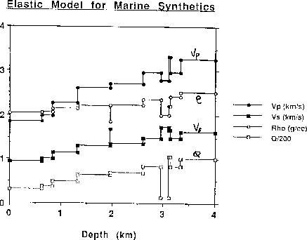
The 1-D elastic
model properties are given in Table 1, and plotted in Figure .
| Depth | Rock | Vp | Vs | Q | |
|---|---|---|---|---|---|
| 630. | 1860. | 930. | 2.04 | 65 | |
| 830. | 1990. | 995. | 2.07 | 75 | |
| 1330. | 2271. | 1135. | 2.14 | 97 | |
| 1960. | 2604. | 1302. | 2.21 | 128 | |
| 1970. | 2697. | 1686. | 1.85 | 137 | |
| 2610. | 2697. | 1350. | 2.23 | 137 | |
| 2960. | shale | 2949. | 1475. | 2.35 | 164 |
| 3110. | gas ss | 2770. | 1731. | 2.00 | 25 |
| 3130. | brine ss | 3321. | 1660. | 2.20 | 208 |
| 3330. | shale | 2949. | 1475. | 2.41 | 164 |
| 4000. | 3250. | 1625. | 2.50 | 199 |
 |