Next: Instantaneous variation
Up: A STRUCTURAL SEISMIC MAP
Previous: A STRUCTURAL SEISMIC MAP
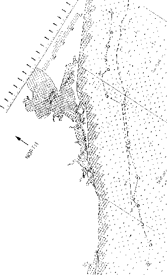
To make the analysis statistically significant, sixteen wells
were selected from the western section of the Gulf of Mexico.
The surface location of these wells as well as of a semi-parallel
seismic line are marked on the map shown in Figure ![[*]](http://sepwww.stanford.edu/latex2html/cross_ref_motif.gif) .
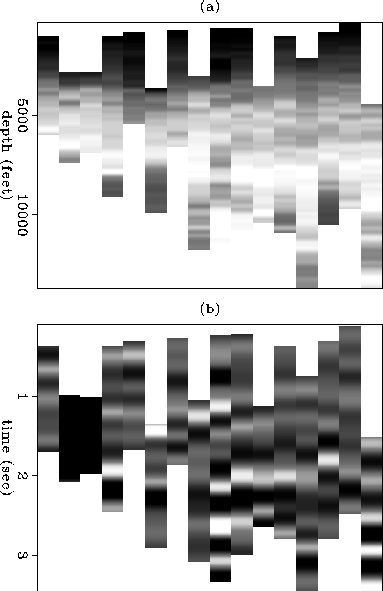
The logs were smoothed with a triangle filter, so that the figure
represents an averaged version of the subsurface slowness.
Figure a shows the sixteen vertically-smoothed
sonic logs. This section represents the major lithologic
features, with young, poorly-consolidated sediments at the top, a
well-delimited high-velocity layer (white region around 8000 ft.), and
a low-velocity zone at the bottom. It can be seen as the result
of a tomographic inversion or other type of interval velocity estimation
using well-to-well, or surface seismic, data.
.
The logs were smoothed with a triangle filter, so that the figure
represents an averaged version of the subsurface slowness.
Figure a shows the sixteen vertically-smoothed
sonic logs. This section represents the major lithologic
features, with young, poorly-consolidated sediments at the top, a
well-delimited high-velocity layer (white region around 8000 ft.), and
a low-velocity zone at the bottom. It can be seen as the result
of a tomographic inversion or other type of interval velocity estimation
using well-to-well, or surface seismic, data.
map
Figure 2 Surface locations of sixteen adjacent wells in the Gulf of Mexico.
The continuous line corresponds to the surface locations of the
sections derived from the well-logs
(Figures and ),
while the dashed line indicates the surface location of the seismic section
shown in Figure .
 section
Figure 3 A seismic section from the Gulf of Mexico. The section is semi-parallel
to the sixteen selected wells whose locations are shown in
Figure . The left side of the top section connects
with the right side of the bottom section.
Because seismic-reflection structures generally represent
isochrones rather than iso-velocity lines, sonic log sections
like the one in Figure a will generally differ from
the seismic sections (Figure ).
There are several ways to transform the
information contained in the sonic logs into a log that shows a
better correlation with the seismic section. The usual way is
to generate a synthetic seismogram using the sonic, or sonic and density, logs.
Figure b shows the synthetic seismograms generated
from the original sonic logs by using a very low-frequency wavelet (central
frequency of 3 Hz)
to avoid spatial aliasing. Although each log correlates well with
its corresponding surface seismic trace, the low-frequency synthetic
section shows some lateral continuity, but only in localized regions.
Likewise, we would find only localized continuity if we
selected sparse traces from a very low-frequency seismic section.
The next section presents an alternative chrono-attribute that
shows a more extensive lateral continuity than the synthetic seismogram.
allsmth
Figure 4 (a) The sixteen adjacent sonic logs indicated in Figure
after vertical smoothing. (b) A low-frequency (3 Hz) synthetic seismogram
corresponding to the sonic logs shown in a.
Next: Instantaneous variation
Up: A STRUCTURAL SEISMIC MAP
Previous: A STRUCTURAL SEISMIC MAP
Stanford Exploration Project
12/18/1997