


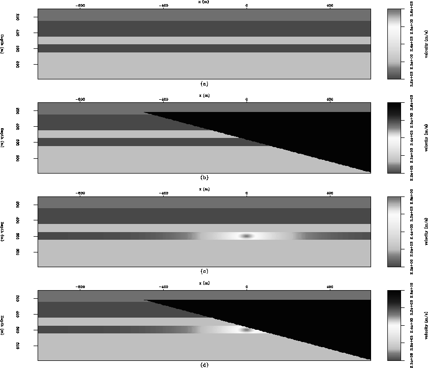
![[*]](http://sepwww.stanford.edu/latex2html/cross_ref_motif.gif) ) using by acoustic
finite difference modeling. Changes in fluid content due to production are modeled as an increasing Gaussian velocity anomaly located
at (x = 0 m, z = 600 m). In each case, we modeled end-on surveys consisting of 201 shots (range: -2000 m to 2000 m, shot
spacing: 20 m, receiver spacing: 20 m, maximum offset: 1200 m) in opposite directions.
) using by acoustic
finite difference modeling. Changes in fluid content due to production are modeled as an increasing Gaussian velocity anomaly located
at (x = 0 m, z = 600 m). In each case, we modeled end-on surveys consisting of 201 shots (range: -2000 m to 2000 m, shot
spacing: 20 m, receiver spacing: 20 m, maximum offset: 1200 m) in opposite directions.
The datasets were migrated using a shot-profile migration algorithm (an adjoint to the forward-modeling operation). By using exactly the same
processing parameters, we preclude frequency, bandwidth and phase differences. Migrated images -- using the correct model velocities -- are shown in
Figures and . Since the actual velocity models are not usually known, it is common practice to migrate
the datasets with the same velocity (e.g. baseline) model. Raw difference images obtained using different velocity fields are shown in
Figures and .
For exactly the same acquisition geometry, the time-lapse response in the presence of the salt wedge (Figure b) is relatively weaker and much more complicated than
when no salt is present (Figure a). Also, as seen in Figures c and d, a change in the acquisition geometry introduces more artifacts
into time-lapse image when the salt wedge is present. These effects result partly from the poor illumination close to the salt flank, unequal illumination of the
salt flank (due to the difference in survey direction) and contamination by differences in the relatively much stronger migration artifacts. As shown in
Figure , using an incorrect velocity field introduces a different pattern of artifacts when the salt wedge is present. Thus, since exact
velocities are not used in practice, any assumptions made with regards to the migration velocities may be difficult to account for. In the absence of the
salt wedge, the results are much less complicated and simple cross-equalization of the surveys should suffice. While opposite acquisition directions
may be an extreme, surveys over very complex salt bodies acquired with slightly different geometries may result in highly deteriorated time-lapse images even
after careful cross-equalization.
 |


