


Figure ![[*]](http://sepwww.stanford.edu/latex2html/cross_ref_motif.gif) illustrates the geometry of the offset-domain CIGs
for a single event recorded at the surface for
the source location S
and receiver location R.
The crucial assumption of our geometric construction
is that the traveltime
along the source ray summed with the traveltime
along the receiver ray is the same for all the
offset directions
and equal
to the recording time of the event
illustrates the geometry of the offset-domain CIGs
for a single event recorded at the surface for
the source location S
and receiver location R.
The crucial assumption of our geometric construction
is that the traveltime
along the source ray summed with the traveltime
along the receiver ray is the same for all the
offset directions
and equal
to the recording time of the event
![]() .
.
In this sketch,
the migration velocity is assumed
to be lower than the true velocity,
and thus the reflections are imaged too shallow
and above the point where the source
ray crosses the receiver ray (SR).
The line passing through SR, and
bisecting the angle formed by the source and receiver ray,
is oriented at an angle ![]() with respect
to the vertical direction.
The angle
with respect
to the vertical direction.
The angle ![]() is the apparent geological dip
of the event after imaging.
It would correspond to the true geological dip
if the migration velocity were correct.
Half of the angle formed between
the source and receiver ray
is the aperture angle
is the apparent geological dip
of the event after imaging.
It would correspond to the true geological dip
if the migration velocity were correct.
Half of the angle formed between
the source and receiver ray
is the aperture angle ![]() .
.
When HOCIGs are computed,
the end point of the source ray (Sxh) and
the end point of the receiver ray (Rxh) are at the same depth.
The imaging point Ixh is in the middle between
Sxh and Rxh
and the imaging offset is hx=Rxh-Sxh.
Similarly,
when VOCIGs are computed,
the end point of the source ray (Szh) and
the end point of the receiver ray (Rzh)
are at the same horizontal location.
The imaging point Izh is in the middle between
Szh and Rzh
and the imaging offset is zh=Rzh-Szh.
When the offset direction is oriented along
the apparent geological dip ![]() (what we called the optimally focusing offset direction),
the end point of the source ray is S0 and
the end point of the receiver ray is R0.
The imaging point I0 is in the middle between
S0 and R0
and the imaging offset is h0=R0-S0.
It is easy to demonstrate
that both Ixh and Izh
lie on the line passing through
(what we called the optimally focusing offset direction),
the end point of the source ray is S0 and
the end point of the receiver ray is R0.
The imaging point I0 is in the middle between
S0 and R0
and the imaging offset is h0=R0-S0.
It is easy to demonstrate
that both Ixh and Izh
lie on the line passing through ![]() .The demonstration is based on the assumption
that
.The demonstration is based on the assumption
that
![]() and
and ![]() .
.
The offsets along the different directions
are linked by the following simple relationship,
which can be readily derived by trigonometry applied to
Figure ;
that is,
 |
(65) | |
| (66) |
Also the shift of the imaging points
Ixh and Izh
can be easily expressed in terms of the offset h0
and the angles ![]() and
and ![]() as:
as:
 |
(67) | |
| (68) |
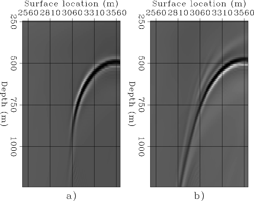
The fact that all three imaging points are aligned along the apparent geological dip allows our transformation to remove the image-point dispersal, and it is crucial to the effectiveness of DDOCIGs. In other words, to transform one set of CIGs into another set we just need to transform the offset axis; the image is then automatically shifted along the apparent geological dip by the right amount. Appendix A demonstrates this fact.
The proposed CIG transformation is a simple
dip-dependent non-uniform stretching of the
the offset-axis according to the relationships
in equations () and ().
The transformation is easily implemented in the wavenumber (kz,kx) domain,
by taking advantage of the well
known relationship ![]() .
.
After both the HOCIGs and the VOCIGs are transformed, they can be merged together. A simple scheme to merge them is a weighted average, where the weights wxh and wzh are set to
| |
(69) | |
| (70) |
 |


