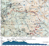
Mineral King to Lodgepole via Big Arroyo
| Summary
| Image Gallery
| Trip Map
- Date: September 1-3, 2001
- Route: Day 1: Start at Mineral King; over cross-country Glacier Pass to Spring Lake. Over Black
Rock Pass to camp at Little Five Lakes. Day 2: Up Big Arroyo, over Kaweah Gap to camp at Hamilton
Lakes. Day 3: Hamilton Lakes to Crescent Meadow via Bearpaw Meadow.
- Total distance: 40 miles.
|

Click Here
| 
Click Here
| |
Background
Believe it or not, by 2001 we had yet to take a single backpacking trip into either Sequoia or Kings
Canyon National Park, even though Kim's brother Robert has worked at Sequoia for two years. The
myth that Sequoia is further from Palo Alto than Yosemite caused this absence. In fact, in the absence
of traffic, I believe that Lodgepole in Sequoia is closer to our house than Tuolumne Meadows in Yosemite.
Long ago, Kim confessed a strong desire to dayhike the Mineral King area in southern Sequoia. Because
this area is so remote (1.5 hours from Lodgepole), I did not want to make a dayhike out of it. I suggested
a compromise: take a four-day backpacking trip from Mineral King to Lodgepole, via the Big Arroyo. From
Mineral King, we planned to cross the Great Western Divide over two passes, Glacier and Black Rock, rather
than the easier, but much longer, single-pass route over Sawtooth Pass and down Lost Canyon. After descending
into Big Arroyo via the Little Five Lakes trail, we planned to cross Kaweah Gap, and drop into the drainage
of the Kaweah River (Marble Fork) on the High Sierra Trail, passing Precipice and Hamilton Lakes. We had
ambitious cross-country plans for the last leg of our trip: enter(and cross) the Tablelands via the Elizabeth
Pass trail and eventually rendezvous with the truck at Wolverton, at the end of the Pear Lake trail. Since
the journey involved over forty miles of steep-topography hiking, ten of which would be cross-country, we
made little attempt to estimate our likely camping spots.
Day 1: Existential Questions, Fish Ballet, and a Moonlight Slog
If you're dong a 40-mile hike between two distant locations, the logistics of car placement can subvert the
best planned backcountry trip. We are forever thankful to Robert for dropping us off at the end of the
remote and treacherous Mineral King Road, and especially for writing us a wilderness permit for the busy
Labor Day weekend. As we parted ways with Robert at the Sawtooth Pass trailhead (elevation: 7800 feet), the
numbers sat like
lead weights in my stomach: 90 degree heat, 3300 feet of climbing to Glacier Pass; 2000 more to Black Rock
Pass, and especially the 40+ miles back to our truck at Wolverton. However, there is nothing like the
good ol' fashioned pain caused by hauling an absurdedly heavy pack up a steep trail to cure one's nervousness.
The Sawtooth Pass trail is quite straightforward until reaching picturesque Lower Monarch Lake at 10,300 feet.
We cooled our heels in this puddle of a lake, surprised by the presence of trout in the relatively shallow
waters. Either the weather is not comparatively cold at this latitude, or larger and deeper Upper Monarch Lake,
300 feet above Monarch, does not freeze solid. Thirty minutes later, as we scrambled up mind-bogglingly loose
scree, hopeless scorn replaced the rapture we previously felt. After struggling up 1100 feet of this garbage,
we realized two disturbing facts: 1) that the USGS 7.5-minute topographical map mis-locates the trail, and 2)
that we had climbed roughly 500 feet higher than we should have to optimally reach Glacier Pass. The USGS
map has the Sawtooth Pass trail first switchbacking up to Glacier Pass (elevation 11,200'), and then contouring
east toward Sawtooth Pass. Tip to the reader: leave the "trail" at roughly 10,800 feet and continue northwest
up gentle scree to Glacier Pass, which is the obvious saddle southeast of Empire Mountain. Anyhow, as we
scrambled toward Glacier Pass after our error, the map fell out of my pants pocket. Unfortunately, I did
not realize this until we reached the Pass, so retrieving it seemed a daunting task.
So there we sat, looking down the seemingly impassible (class 4-5) cliffs of Glacier Pass. Without a map,
I had little clue on the best route down, and frankly, I couldn't convince Kim that this was really
Glacier Pass, since we both knew that the trail seemed to reach the pass. Kim asked me the question that
I didn't want to hear, because I knew my answer was "yes": Do you want to go back?. Luckily, after
a sausage/cheese/tomato/Dijon mustard sandwich, we were in a mood to check out some possible routes down.
I suddenly recalled that I'd brought along Bob Burd's trip report, which I hadn't had time to read before
our trip. He described the same mislocation of the trail on the map, and also the easiest route over Glacier
Pass. Thank you, Bob!
After some easy boulder-hopping down from Glacier Pass, we took in magnificent views of the Great Western
Divide, as well as Spring Lake, which sits in the glacial cirque at the head of Cliff Creek. Michael Golden,
who accompanied Bob on his trip, gave Spring Lake a hearty recommendation, and it did not disappoint.
We reached the lake around 4 p.m., and I had (for us) a novel hiking strategy: relax for a few hours and
eat dinner at Spring Lake, then continue over Black Rock Pass using the moonlight that I knew would come.
Noticing considerable surface action, I broke out my fly rod and casted a Caddis Fly imitation toward the
expanding circles. Thirty minutes later, I had four 6-8" Brook Trout in my possession, which came at the
cost of three flies and countless feet of tippet, thanks to the trees that I would snag while setting the
hook on an uninspired strike. Kim and I rested our sore muscles and ate a tasty meal of poached trout and
Spanish Rice. As we munched, we lazed in our therm-a-rest chairs, enjoying alpenglow set in on the Great
Western Divide, as well as a veritable ballet, performed by the thousands of fish leaping from the glowing
orange surface of the water. At any one time, easily a hundred fish were fully airborne.
By 7 p.m., we were moving cross country, hoping to meet the imposing switchbacks of Black Rock Pass without
losing too much of our hard-gained elevation. In the end, I found it easiest to simply follow game trails
northwest along Cliff Creek, rather than cross a legion of loose rockfall chutes. Near the 9500-foot level, we
climbed north to meet the Black Rock Pass Trail at 8 p.m., just as the sunlight became unusable. At first,
we hiked with headlamps, and I was nervous, thinking that the full moon that I'd promised Kim wouldn't come
for a while. Luckily, the bright orb rose into view roughly fifteen minutes later, and we hiked comfortably
in the cool, still night air without our lamps. The lack of proper illumination has the strange effect of
"two-dimensionalizing" the entire panorama. The mountains on the other side of Cliff Creek, two miles distant,
looked as though I could reach out and touch them. More importantly, we could see our destination, Black
Rock Pass, as simply a point above us on the plane. Though exhausted, we simply put our heads down and
humped up a thankfully-smooth trail, and magically, by 10 p.m. we reached the 11,700-foot pass. We munched
trail mix, re-hydrated, and donned jackets to insulate from the surprisingly cold temperatures and high
winds. You can't make out much from the pass at night, which is just as well, because we wanted to make
double time to our campsite at the highest of the Little Five Lakes. We found a reasonable spot at 10:30
and bedded down for the night, truly exhausted after 5500 feet of climbing (and 2700 feet of descent) along
our 10-12 mile route.
Day 2: Beyond Ansel Adams
When I awoke, my watch noted that the temperature inside our tent was 38 degrees fahrenheit. Which is fine
with me, since I have a 15-degree bag. Kim, however, has a 0-degree bag...0 degrees celsius, that is.
The disparity in our sleeping bag insulation causes us endless woe; I'll be sweating and naked in my bag on a
40-degree night, while Kim will be dressed in long underwear, shivering in hers. We slept in, then took a
breakfast of coffee and oatmeal, while enjoying views of Black Rock Pass, the GW Divide, as well as of the
mind-blowing Kaweah Peaks. I also wondered where my sunglasses were. Evidently I left them somewhere along
the shore of Spring Lake. As I squinted into the brilliant alpine sun, I wondered how my eyes would fare
in the brilliant afternoon sun reflected from the smooth granites of the Tablelands...
As we trounced down the trail through the Little Five Lakes region toward Big Arroyo, I was struck with
a sense of overwhelming fatigue. We cursed every little climb, panting. Evidenly, yesterday's epic
struggle had taken its toll. Luckily, today's hike would prove tame by comparison. We rendezvoued with
the High Sierra Trail at 9500 feet, descending from our camp at 10,700. From there, the trail climbs a
mere 1200 feet--steadily--over 5 miles to Kaweah Gap. Big Arroyo is simply incredible eye candy. On
the west sit the inviting granite monolths of the GW Divide; on the right, the massive "roof pendant"
Kaweah Peaks. I regret that my general fatigue inhibited my enjoyment; luckily our pictures remind me
of the grandeur.
The climb to Kaweah Gap was merciful, though the views were not much more spectacular than in the Big
Arroyo. We bade the Kaweahs goodbye, and were soon greeted by that old recluse, Precipice Lake. Ansel
Adams made a famous photograph here. While it does capture some of the mystery of this place, I don't
believe it does the lake full justice. If Adams couldn't capture it in film, I certainly won't capture
the grandeur in prose. But if you will humor me, imagine an incredibly deep, incredibly clear, incredibly
dark blue lake, buried in the shadows of the glacier-studded 1800-foot cliff on the north face of Eagle
Scout Peak, and behold...Precipice Lake.
Part of us wanted to camp at Precipice Lake, in spite of the lack of good campsites. Nontheless, I knew
that we needed to push on as far as possible, to maximize our flexibility for the remainder of our trip.
We decided to continue to Hamilton Lakes, three miles distant and 2500 feet below us. The High
Sierra Trail is a marvel of engineering, blasted directly into (and sometimes through) the cliff walls.
Trails like this are no longer constructed by the National Park Service, for reasons that make me rant.
In any case, the last segment of this day's 11-mile hike reminded us that with a full pack, the descent
is often just as taxing as the ascent. By the time we reached the main Hamilton Lake, our feet and joints
screamed in displeasure. Distressingly, a large, rowdy group occupied all the lake's six campsites.
Undeterred, we set up camp in an unofficial, but nice, campsite and again watched alpenglow and fish
dancing, though I kept the rod in its case. At the lower elevation (8235'), I baked in my sleeping bag
and slept quite badly.
Day 3: The Safety of a Well-Beaten Slog
I failed to mention that, yesterday, we made a change of plans. Having had enough adventure, we opted
not to take the cross country route across the Tablelands, and instead planned to follow the High Sierra
Trail past Bearpaw, then up to Wolverton via Panther Gap and the Alta Peak trail. As mentioned above,
the thought of crossing this flat, white expanse, sans sunglasses felt pretty unappealing, particularly
after 23 miles of hiking. Moreover, the NPS's unofficial name for this cross country route is "Thunder
and Lightning Pass", with the nomenclature underscored by the previous day's impending thunderstorms.
Curiously, Secor calls this "Pterodactyl Pass"; why, I don't know.
We got an early start, hitting the trail around 8:30 a.m. The smooth granite domes and grand views up
to Kaweah Gap made "Valhalla" a particularly enchanting place. Considerably less enchanting was the
graduate student bar of the same moniker at my alma mater, Rice University. After five miles or so,
we reached Bearpaw Meadow. The blistering temperatures and civilization made us particularly glad that
we weren't forced to camp here. A backcountry ranger, Nina, is stationed here. She convinced us to
forego the climb to Panther Gap and simply hike on the HST to Crescent Meadow directly. Robert wouldn't
mind picking us up, because "that's what brothers are for." I felt like a real maggot when she put
out a call over the radio for "617 to pick up his sister at 1800 at Crescent Meadow."
This segment of the HST is 12 miles long, fairly flat, and fairly unimpressive, with the surroundings
oscillating between thick pine/oak forests and brutally exposed sections blasted from the granite.
Still, the views of the Kaweah's canyon were uncharacteristically clear of air pollution. The distance
to the ever-receding Kaweah Gap amazed us. At one point, we could even see most of the way up Cliff
Creek Valley, back toward Glacier Pass. What a cool way to end our trip. Our feet completely
obliterated, we staggered to Crescent Meadow around 5:30 p.m., having hiked a whopping 17 miles from
our previous night's campsite at Upper Hamilton Lake. The popcorn of expanding thunderstorms
validated our decision to "wimp-out" from a crossing of Thunder and Lightning Pass.
Epilogue: A Day of Rest and our Search for the Elusive Weight
Finally...a day with absolutely nothing to do, and in a beautiful, pine-smelling place at that.
We lounged around, watching with great satisfaction serious thunderstorms building over Thunder and
Lightning Pass. As I looked at Kim's horrid blisters, I finally knew that the "weight problem"
needed to be addressed before we took another backpacking trip. I felt as if I packed in a fairly
spartan manner, though my pack weight is almost invariably greater than 50 pounds. For shits and
grins, I unloaded my enormous
Arc'teryx Bora 95
(6500+ cubic inch) pack, save our
Marmot "Swallow" tent.
Sure enough, tent+pack weighed somewhere between 15 and 20 pounds. Add to that clothing, bear can, food, sleeping bag,
thermarest, and other accoutrements, and you can see how 50 pounds is easy to achieve.
Our tent is overkill. 3/4 season rating; probably as heavy as some 4 season tents. I believe total weight
is around 8 pounds. This must change. Second, I could cut my clothing cache to save a pound or
two. I'd love dearly to dispense with the bear can. Some people would say that two summer sausages, a pound
of cheese, eight rolls, and six tomatoes absurd. I vehemently disagree! Never have I had such satisfying
backcountry lunches. Even after 17 miles on our last day, I felt strong. I attribute this endurance to
proper eating and sufficient hydration. Our goofy Camelbak bags assisted in the latter. These things
kick butt--you end up driking 3 times as much. Anyone who denies the value of drinking enough water is
smoking crack.
© 2005
, Stanford Exploration Project
Modified: 11/18/05, 13:53:02 PST
, by morgan
Page Maintainer: morgan `AT' sep.stanford.edu


