
![]()

![]()

![]()
![]()
![]()
![]()
![]()
![]()
![]()
![]()
![]()
|
Recommends...
 By Paul Richins Jr.. Decent info, lots of good skiing ideas. Approaches/descents often imprecise--bring a map! |
 Mount Tallac
|
|
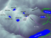
| Summary | Image Gallery | Trip Map
|
|
| 
|
By mutual agreement, a backcountry ski trip around Lake Tahoe was to be the highlight of our honeymoon. Mount Tallac ranks highly among the popular backcountry destinations around Tahoe. Our plan was to park at the end of Spring Creek Road at 6500', then hike up the northeast ridge of Mount Tallac and ski the east bowl.
Warm spring weather made our outdoor wedding in Yosemite Valley an overwhelming success. The same warm weather turned the snow on Tallac's east-facing to a slushy mess, which would wreak havoc on my fledgling, resort-honed telemark skiing skills.
After penetration of a thick forest [ pic 1 | pic 2 ], the northeast approach to Tallac is surprisingly devoid of any real forestation, instead boasting a (mostly hidden) undergrowth of shrubbery and immature pine trees. We walked without difficulty over the consolidated snowpack, leaving our climbing skins idle in our daypacks. On south-facing slopes, I postholed through the snow and into the shrubs. In spite of this harbinger of the end of winter fun, the east bowl still boasted a five foot snowpack.
On topographical maps, the distinguishing feature of Tallac's east bowl is a molar-shaped flat just above the 7400' contour. After reaching the flat, we crested the northeast ridge and began the strenuous, monotonous climb toward the summit [ pic 1 | pic 2]. We were passed by a couple well-conditioned randonee skiiers around 8000'. We stopped for a much-needed rest near the 8500' contour, took in the stunning views of Lake Tahoe to the north and Fallen Leaf Lake to the east, and prepared to ski! Above this point, the bowl steepens and narrows. I worried a bit about the spring avalanche conditions, particularly in the very warm weather. Perhaps my worries were unfounded -- I hope to find out soon.
To make a long story short, the skiing was tough and tensions high. In the warm east sun, the snow turned to thick slush, but remained stubbornly frozen in shaded patches, making for some hairy terrain! I struggled mightily on the unfamiliar snow, falling hard and repeatedly. When I managed to earn some truns, they were sloppy in spite of the fairly easy terrain. Per usual, Kim looked very solid.
We wearily reached the "molar flat" at 7400' and walked much of the way
back to the car, where we had the fight that had been brewing for the
whole trip. We don't fight much, and when we do, we make up quickly.
Soon we were
back in the hot tub
and enjoying the scenery around Tahoe
[ pic 1 |
pic 2 |
pic 3 ].
|
Department of Geophysics Stanford University |

|