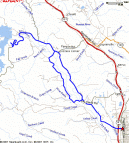
| Mile | Action | Comment
|
| 0 | Healdsburg - Dry Creek Road |
Good, wide-shouldered road here.
|
| 2.5 | Cross Lytton Springs Road | Whew, it was cold! And what a headwind!
|
| 4 | Cross Lambert Bridge Road | Take note: Good food at the Deli! Terrain is fairly flat; stays just below 200'
|
| 9 | Cross Canyon Road | Road is smooth & pretty flat, but shoulder narrows
after Lambert Bridge Road.
|
| 13 | Reach Warm Springs Dam | Keep going up the paved road. Do you see the big dam?
400' climb in next 2 miles!
|
| 15 | Left on Skaggs Springs Road | Signs should point to Gualala, and Lake Sonoma Overlook.
Start with straight, nasty 200' climb.
|
| 15.5 | Right to Lake Sonoma Overlook | Killer climb! 200' in a quarter mile!
But nice views!
Another.
|
| 17.5 | Back to bottom of dam | Go back the way you came. Control your speed on the steeps! 50 mph comes quicker
than you can imagine.
|
| 20 | Ferrari-Carano Winery |
Great flowers,
but they charge $2 for tasting. :(
|
| 21 | Right on Yoakim Bridge Road | Cross Dry Creek.
|
| 21.5 | Left on West Dry Creek Road | This road is hillier, more narrow, less crowded, and
more scenic than E. Dry Creek Rd. Elevation oscillates between 150' and 200'.
|
| 25 | Left on Lambert Bridge Road | Stop at the cool wineries here. We hit
Pezzi-King Winery
and came home with a bottle. You'll cross a cool old bridge. Yes, it's named
"Lambert Bridge".
|
| 26 | Right on Dry Creek Road | Don't forget to get lunch at the
Dry Creek General Store!
|
| 30 | Finish in Healdsburg | Congratulations! You just did a 30-miler.
|
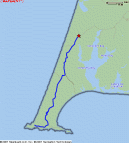
Trip 2: High Above the Sonoma Coast
| Summary
| Image Gallery
| Trip Map
- Date: April 3, 2001
- Route: Climbed Meyers Grade Road. Turns into Seaview Road. Rode until Fort Ross School and retraced
route back.
- Total distance: ~19 miles. Total climb: ~2000 feet
|
Click Here
| 
| |
A mind-blowing ride, with a first hill that thwarts casual attempts at climbing it!
In most places along the California coast,
it is difficult to ride high along the coast range, since the drainage -- and deep canyons --
are generally perpendicular to the coastline. However, the San Andreas Fault comes
ashore near Jenner, California, and the drainage of the Gualala River actually runs parallel
to the coast. Meyers Grade Road, later Seaview Road, runs along a high, fairly flat ridge,
often with a good view of the coast. We did this ride on a cold, clear day, and managed to
beat out some nasty thunderstorms. We will not soon forget this incredible ride. Please
enjoy our feeble attempt to immortalize it with words and pictures.
| Mile | Action | Comment
|
| 0 | North, Highway 1 | About 3 miles north of Jenner, on the left side of the road, is a
good parking spot. Starting elevation: 600'
|
| 0.5 | Right, Meyers Grade Road | Starts flat, but watch out -- the first road sign you'll
see says "18% grade ahead"! In about 1.5 miles, you
will climb 1000'. Prepare to battle this
amazing road!
|
| 1.5 | Thick grove of trees | When you are in this
grove of trees,
you may think you are done with the climb. Ha! Think again. You climb from 1000'
to 1100' in the shady grove.
|
| 2.0 | Top of Hill | Done! When you finish this incredible climb, your altimeter will read around 1400' and
your eyes will be rewarded with this view.
|
| 5.0 | Cross Fort Ross Road | The terrain is rolling, oscillating between 1400' and 1600'. Dig out the
climbs and enjoy the 35 mph downhills. Oh, and don't forget to enjoy
scenery up here!
The road is now named Seaview Road.
|
| 7.5 | Start a steep downhill | Be careful! After the village of Seaview, you start a long downgrade, at the end
of which you'll have lost 500' of your hard-earned elevation.
|
| 9.5 | Turn around - Timber Cove Road | The Fort Ross School, a good water stop, is near this junction. We
turned around here, but you can easily keep going, and have
many choices. Elevation: 1000'
|
| 19 | End - Retrace your steps | But don't forget to enjoy the scenery, especially in the high sections
on Meyers Grade Road, near the start:
Pic 1 |
Pic 2 |
Pic 3.
|
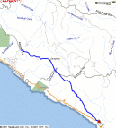
This is a fantastic trip, but it hardly merits a detailed description. You just park, then follow the road
until it ends. No single climb is more than a few hundred feet, but there are so many of them that it
really adds up! My guess from topo maps of 1900' is probably an upper bound. You'll pass 2 or 3 of the
"letter farms"
that have operated at Point Reyes since the 1850's, and smell their cows. Be prepared for wind, even on a
nice day. The road is in crappy shape, and there
really isn't a shoulder,
so I wouldn't recommend this drive
for a busy weekend day (it was busy enough on wednesday). Once you make the final tough climb to the lighthouse,
you'll be rewarded with great views in every direction [
one |
two |
three |
four ].
After three days of riding, I was truly bushed.
Although not as obvious of a climb as Meyers Grade, the endless ups and downs on this route will really take it
out of you, especially if a headwind is involved!