


Although the most powerful geophysical technique, deep reflection seismic profiling has usually been undertaken at very regional scales. Processing schemes applied to such data are conventionally simplistic, mainly a symptom of the problems in differentiating between (weak) signal and noise. The long-standing attitude has been that complex processing routines can not be used with confidence or reliability. Many of these problems of course relate to the unique characteristics of deep seismic data. Migration has been perhaps the biggest challenge, due to the large aperture inherent in a 12-20 s TWT section (Warner, 1987). Even the fundamental aspects of the seismic method have associated complexities. Of interest to any seismic study, the accurate determination of rock velocities are of fundamental importance. From a regional standpoint, wide-angle refraction seismic profiling is often preferable to reflection seismic profiling, as rock velocities can be better estimated using refraction data. Advanced first-arrival inversion routines (e.g. Hole, 1992) are now able to produce detailed 2.5D tomographic velocity models, even when the acquisition involved irregular and crooked recording geometries. In contrast, the lack of perceptible moveout at depth on CDP gathers makes velocity determination difficult and imprecise. It is not uncommon that refraction data are used to constrain the velocity models input into CDP stacking of reflection seismic data.
Crustal-scale surveys are of course acquired over very large distances, commonly several hundred kilometers, which will usually involve traversing rugged and variable topography. Often these problems are so extreme that remote recording stations are left switched on in (passive) recording mode for several days, while various shots are detonated along the line. The continuous records are then deciphered back at home. This style of recording dictates a coarse receiver station spacing, which in turn dictates that the data will be dominated by long wavelengths and low frequencies. As such, the required processing scheme is relatively simplistic by comparison to that required for imaging of shallow exploration data.
Furthermore, most processing schemes are unique to the particular
datasets being processed. An example is the imaging of the major
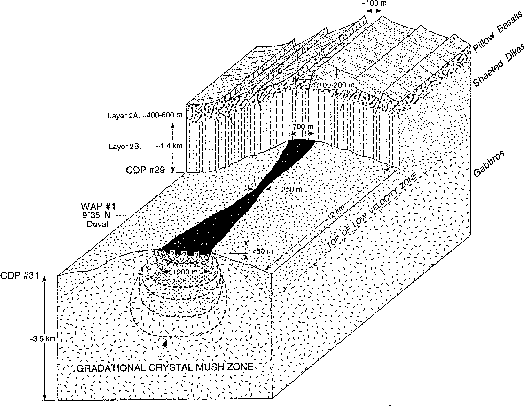
features beneath mid-ocean spreading ridges, where new oceanic crust is
formed and rafted away on diverging tectonic plates. Figure ![[*]](http://sepwww.stanford.edu/latex2html/cross_ref_motif.gif) shows the
oceanic crust to be composed of 3 (seismically) distinct layers: layer
2a (sediments, pillow lavas and extrusives) which varies between
200-500 m thick, layer 2b (sheeted dykes) which is 2-3 km thick, and
layer 3 (gabbros) which extends down to the common oceanic crustal
depth of 7-8 km. Beneath the mid-ocean ridge (MOR), an upwelling
axial magma chamber (AMC) supplies the material required to generate
new crust as the plates diverge. The two features commonly of most
interest are the variable thickness of the 2a layer (which reveals much
about the tectonic evolution of the upper-crust) and the width of the
AMC (which reflects the ``magma budget'', a key control upon the
along-axis structure and morphology of the ridge).
shows the
oceanic crust to be composed of 3 (seismically) distinct layers: layer
2a (sediments, pillow lavas and extrusives) which varies between
200-500 m thick, layer 2b (sheeted dykes) which is 2-3 km thick, and
layer 3 (gabbros) which extends down to the common oceanic crustal
depth of 7-8 km. Beneath the mid-ocean ridge (MOR), an upwelling
axial magma chamber (AMC) supplies the material required to generate
new crust as the plates diverge. The two features commonly of most
interest are the variable thickness of the 2a layer (which reveals much
about the tectonic evolution of the upper-crust) and the width of the
AMC (which reflects the ``magma budget'', a key control upon the
along-axis structure and morphology of the ridge).
 |

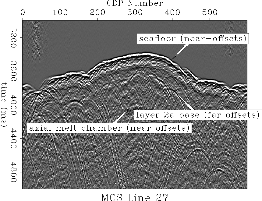 |
As a pronounced velocity
gradient exists within the 2a layer (from 1.5 - 5 km/s), many of the
recorded seismic events are from turning ray energy, which is commonly
only recorded at offsets greater than 1.5-2 km.
Conversely, the best resolution of both the seafloor and the AMC are
obtained from near-vertical reflections. Hence, one processing
approach successfully used has been to produce 3 separate stacks;
2 using near-offset reflections to image the seafloor and AMC
respectively, and 1 using far-offset reflections to image the base of
the 2a layer. These 3 stacks are then merged to produce a single
output stack (Fig. ). Such an approach does not favor the subsequent
successful application of migration, a problem further compounded by
the presence of significant diffraction energy related to seafloor
topography, which is often out-of-the-plane.
This is of course only a single, isolated example. Nevertheless, it demonstrates the often unique and simplistic approaches required to image regional deep seismic data.