

![[*]](http://sepwww.stanford.edu/latex2html/prev_gr.gif)


ABSTRACTThe last 10 years has seen a steady increase in the number of 3-D seismic surveys. This increase has led to a push to develop innovative tools to deal with the unique challenges that 3-D data present. SEP has chosen to work within the framework provided by Advanced Visual Systems (AVS) for its 3-D work. This paper attempts to summarize current status of SEP's AVS environment; provide some useful hints when problems are encountered running AVS; and give a brief overview of where we are headed in the near future. |
INTRODUCTION
As 3-D seismic data becomes the standard rather than the exception, new tools have to be developed to deal with the new challenges that 3-D data presents. Currently, several software packages/companies (GOCAD, Landmark, AVS and GSI) are competing to provide the seismic world with tools to meet these challenges. SEP has chosen to use AVS as its 3-D platform due to its flexibility and large user base inside and outside the seismic industry. AVS offers an interactive 3-D display environment that is not available in standard Unix (SEPLIB), and allows rather straightforward inclusion of Unix batch programs into it's environment, unlike GOCAD. In order to provide people inside and outside of SEP a brief guide to what we can now do with AVS, I have attempted to provide a synopsis of SEP's current AVS abilities. The paper is broken down into three parts. The first part summarizes some useful networks available at SEP and how to use them. The second part is a brief summary of the modules developed at SEP, and the final part attempts to answer some of the more common problems that occur when using AVS. USEFUL NETWORKS 3-D View Creates a 3-D object from a 2-D slice. The third dimension is created by transforming the independent values in the 2-D array into the z-coordinate. First, select the dataset using the file browser widget attached to the Read SEP module. Choose the scale boolean widget if scaling is appropriate (when axis ranges are not comparable). Once the dataset has been chosen a 2-D slice must be selected. The ortho slicer performs this function. It allows the user to select a 2-D plane from a 2 or 3-D input array. The user specifies which dimension to slice along, and which plane along that axis to select (using the attached choice and slider widget). The slicer is defaulted to slice along the third dimension and to select the first slice in that dimension.
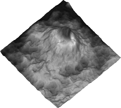 |

Once the appropriate parameters have been selected within the ortho slicer the data is passed to the field to mesh module. The field to mesh module then converts the data 2-D array of values into a 3-D surface by mapping each value of the array to given elevation determined by the value at the coordinate location multiplied by the Z scale dial widget value. Figure 3dview2 illustrates a sample geometry viewer scene, in this case a phase unwrapped view of Mt. Vesuvius (see ()). The network also allows the user to include a color table through the generate colormap module (see Generate Colormap Troubleshooting if problems are encountered). Further the image to postscript module is included to allow scenes in the geometry viewer to be captured into a postscript file. The name of the postscript file is determined through the attached file name typein widget. Isosurface
 |
Constructs an isosurface(s), which can be thought of as a 3-D representation of a 2-D contour line. The cube is selected using the file browser widget within the Read SEP module. In the isosurface module(s) select the value to map (level dial widget). The resulting image should have the form of Figure isso. If it does not appear in the geometry viewer, follow the procedure under Geometry Viewer Troubleshooting. If you are unsure what to map, the Generate Colormap Troubleshooting section might help.
Modeling
Uses Martin Karrenbach's modeling code to perform 2-D acoustic modeling. The user selects the header file of the velocity cube using the file browser widget attached to the Browser_cm module. This information is passed along to the Browser cm module which reads in the portion of the dataset defined by the user by the slider widgets entitled (f1, f2, f3, f4, j1, j2, j3, j4, n1, n2, n3, n4). Once the user has defined the portion of the dataset they want to read in, one selects the browser enter boolean widget, allowing the field to be passed along to the Slicer cm module. The Slicer cm module selects which plane to model by altering the HAxis, VAxis, and slice number widgets. In addition to the velocity slice, Ultimod requires a wavelet as input. Using the SEPLIB program Wavelet or something comparable the user create the desired wavelet.
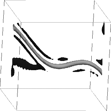
The next step is to set the desired parameters within Ultimod. The source location is modified by the src_depth and src_i widgets, all other parameters are fairly self explanatory. When the desired parameters have been set, execute the module through the runit boolean widget. At this point the time snaps should be fed to the geometry viewer. If they do not appear select the network execution from network tools menu. If the slice is not visible within the Geometry Viewer (Figure snap2 gives an example of what you see superimposed on a GOCAD surface model ()) follow the procedure described in Geometry Viewer Troubleshooting . If the entire slice appears to be a single color, or has a very limited resolution follow the procedure under Generate Colormap Troubleshooting. The image can be additionally improved by modifying the Gain_cm module's widgets.
 |
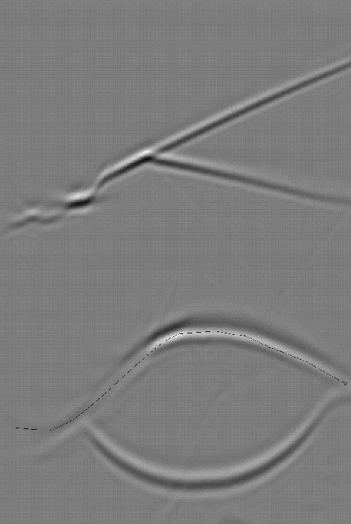
Pick Info Allows a line to be drawn on a 2-D slice, and the coordinates of the selected points to be saved into a SEP file. First, select the dataset to be loaded using the file browser widget in the Read SEP module. If the axes are not compatible (such as one goes from 0 3000, the other 0 to 5), choose the scale option. Select the plane to be viewed using the ortho slicer. Follow the procedure under Geometry Viewer Troubleshooting and Generate Colormap Troubleshooting, to bring up and improve the resolution of the image. Then begin selecting points on the image. If you make a mistake you can use the remove point boolean widget. If you wish to start a new line select new line boolean. Figure picking illustrates how the geometry viewer scene will look with the superimposed picked line on top of the 2-D slice. Once you have selected the lines choose the write line boolean widget. The selection writes the line to the Write SEP module. Make sure that the pick boolean widget is highlighted, so the module knows to convert the 3-d array into a 2-d array. Additionally finally within the Write SEP module choose the dataset name, and then select the writeit boolean.
 |
View GOCAD
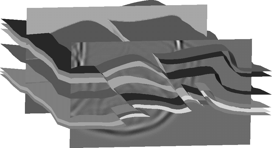
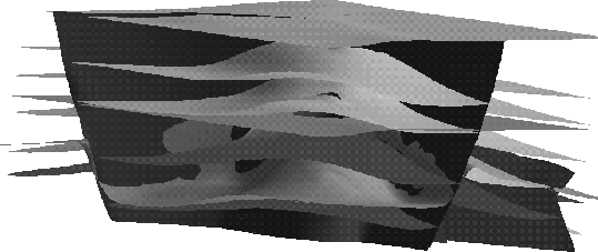
Allows viewing of surfaces defined in GOCAD. Use the file browser widget labeled project to select the directory that contains the desired project. Then click on any file within the directory, such as G.0, and the list of surfaces contained within the project will appear in the browser labeled surface. Select either a single surface, or all the surfaces to load. You can either repeat the procedure to load additional surfaces or modify the views by following the Geometry Viewer Troubleshooting (Figure viewgocad).
 |
AVS MODULES DEVELOPED BY SEP
AVSGOCAD
The AVSGOCAD module operates as the main translator between AVS and GOCAD. It takes as input SEP_1 (which is structure containing the surface name, project name, and associated pick information) and checks for the name of the project and surface. It then uses GOCAD library functions to read the binary form for the selected surface(s). It converts the information into an AVS polytriagonal geometry object. The color of the surface is determined by the color browser widget. The module also allows the user to construct an object hierarchy (parent-child concept), which allows various parts of the model to be grouped together, and given properties as a whole rather than individually.
Browser_cm Browser_cm takes the name of a file as input and then reads some portion of that dataset onto the CM. Which portion of the dataset to read in is controlled by the attached widgets (n1, n2, n3, n4, j1, j2, j3, j4, o1, o2, o3 and o4). All of whose function conform to the SEP conventions. Once the desired portion of the dataset has been selected, the user selects the browser enter boolean widget to read the dataset and pass along the resulting array downstream.
Create Line Create Line allows the user to create a line from a series of picks within the geometry viewer. The module takes as input the SEP_1 data type (usually from the Pick Geom module) from which it extracts the 3-D location of the selected point. When multiple points have been selected it constructs a series of disjoint lines connecting the selected points. In addition it allows the user to: change the color of the line (through the red, blue, and green widgets); erase a selected point (delete point boolean widget); and start another line (newline). With each additional selection a 3-D array (3, maximum number of points selected in a line, number of lines) is added too. When the user has finished creating the line(s). The user selects the writeit boolean to pass the information downstream.
Gain_cm Gain_cm applies gain to a selected slice/volume that is currently residing on the CM. It has two attached widgets, gpow and clip . Both of these widgets operate in the standard manner.
Pick Geom
With Pick Geom the user can select any point on any geometry object in the 3-D volume visible in the geometry viewer. The module uses the AVS upstream geometry concept to obtain information from the geometry viewer. Once the user selects a point in the geometry viewer a sphere of size and color defined by the user (the red, green, blue, and radius slider widgets) is placed at the selected location. The user has a choice of either selecting the exact point of the mouse or the nearest vertex on the selected geometry object (controlled by the Choices widget). Once a point has been selected by the the user the name of the object, the selected point's location, and any primitive data associated with the point is passed downstream through the SEP_1 data type .
Read SEP Read SEP mimics the standard input Unix command. Through an attached file browser a user selects a standard SEP header file. The validity of the header files is checked and the values for (n1, n2, n3, n4, d1, d2, d3, d4, o1, o2, o3, o4, and esize) are read in. The module then creates an AVS field with the correct dimensions and calculates an extent array. If the scale boolean widget is active it sets the minimum and maximum extents array so that each pixel represents one position in modeling space and that the model is centered around (0,0). If scaling is not chosen the d1,o1,d2,o2,etc parameters are used to construct an extent array that accurately reflects the model.
Slicer_cm
Slicer_cm performs the same basic function as the standard AVS module ortho slicer. It takes a 2+-D volume that resides on the CM and selects a single 2-D slice. It has two attached typein widgets HAxis and VAxis to select which plane to preserve and slider widgets along the other dimensions.
Surface Name Surface Name is used to select the GOCAD project and surface(s) to load. The user selects the desired project using the file browser widget labeled project. The module then scans the .file2gobj in the project directory for the list of surfaces contained within and outputs the list to the browser widget labeled surface. Once the user selects the surface the module passes the name of the project and surface (through the SEP_1 data type) on (usually) to the AVSGOCAD module.
TraceGeom TraceGeom displays survey acquisition parameters. It takes as input two AVS fields (one for source location and one receiver location) and outputs a 1-D, 3-vector array. It allows the user to display either source-receiver, midpoint-offset, bin-fold, or bin-offset using the Display Type choice widget. The user can reduce the amount of data displayed by modifying the (N Mid x, N mid Y, O Mid x, O Mid y, D Mid x, D mid Y, N Traces, First Trace, J Mix X, and J Mid Y widgets). The specified output is then sent downstream, normally to the scatter arrow module.
Ultimod
Ultimod is based upon Karrenbach's elastic wave propagation modeling program (). It can perform 2-D acoustic modeling in real time. It takes as input a 2-D velocity slice and a wavelet. It allows the user to modify the source location, maximum frequency, number of time slices, slice interval, etc.
Write SEP Write SEP operates similar to the standard output convention in Unix. It uses a file browser widget to select the output path for the header file. If the scaling pipe is connected, it checks to see if scaling has been applied. It then checks to see whether the input data is from a 2-D picking routine (pick boolean widget) in which case the data is transformed into (data in the SEP format esize=8) data containing the x and y coordinates. The module obtains the dimensions and extents from the input AVS field, converts them to the SEP conventions (n1,d1,o1,etc.), and finally uses auxputch and srite, to write out the dataset. The dataset is written when the user selects writeit.
OTHER USEFUL HINTS
Getting Started
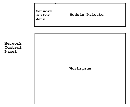
The left portion of the network environment, the Network Control Panel, contains the list of modules currently in the network and for the selected module the attached widgets (see Figure overview). The right hand portion, the Network Construction Window, is the main working environment. The top, right column of the Network Construction Window, the Network Editor Menu, contains general flow controls. To the right is the list of modules, the Module Palette. They are generally sorted into a series of module libraries (SEP, public, supported, imaging, etc) and then more specifically categorized by type (Data Input, Filters, Mappers, and Data Output).
 |
|
widgets
Figure 2 Example of the several types of widgets available within AVS: Edit-Load-Save shows a choice widgets; projectin is an example of a file browser widget; color, a choice browser; newgroup a typein widget; remove object a boolean widget; red is a slider widget; and ohor a radio dial. | 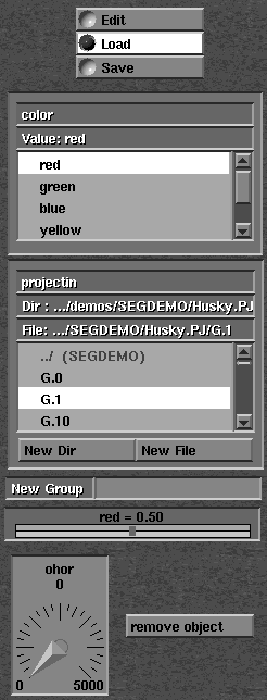 |
Beneath the module library is the Workspace. It contains the flow that the network will execute. Modules are connected through color coded pipes, corresponding to the type of data that they pass. Modules can be brought into the working area by dragging them down from the module library while depressing the left button. They can be connected by first selecting an input/output port with the middle button and than highlighting the desired connection. To destroy a connection the right button is selected while the mouse is positioned upon either the input or output port of the desired pipe. The user then highlights the desired pipe to remove the connection.
AVS uses several different types of widgets, which are comparable to UNIX parameters, the most common of these are shown in Figure widgets.
Learning to effectively operate the geometry viewer is probably the most confusing aspect of AVS. Rather than going into detail in the operation of the geometry viewer, it is probably better to summarize some of the most common encountered problems and their solutions.
Make sure that the geometry viewer is set to Transform Object, and the object selected is ``top''. If another object is selected click in a area of the geometry viewer where no objects are present. Once these two conditions have been met, select the normalize button. The viewer should now contain all objects that have been created. Switch to Transform Camera before you proceed any further.
The most common cause is that at one point Transform Object mode was selected and only one geometry object was modified instead of the entire scene. The easiest solution is to recreate the object in question. If the misplaced object does not disappear, follow the procedure under removing objects .
As a first approach select Lights and than select Bi-Directional. If the scene still appears poorly lighted the direction of lights can be modified by first selecting Transform Light and than using the standard geometry viewer commands to change the direction and location of the lighting. Make sure to change back to Transform Camera when finished.
Select the box next to the name of the currently selected object, located above the miniature view of the scene. A dialog box will then appear containing the names of all the objects in the scene. Select the unwanted object, select Objects, and select Delete Object.
Generate Colormap Troubleshooting
A problem that is commonly encountered when displaying a slice is that it appears to be a single color, or has an extremely limited resolution. This is most likely caused by an error in the definition of the color table. The generate colormap contains two dial widgets, min and max variables, which controls what values of the slice will be mapped to a specific color. By changing these values, the resolution of the image can be improved. If the user is unsure of what values to choose for the min and max, the statistics module, found under the Data Output category, in the Supported, subgrouping, can be connected to the field socket leaving the orthogonal slicer.
FUTURE WORK
As with SEPLIB itself, SEP's AVS environment is always expanding and changing. Currently we see two main fronts for improvement, model building and data viewing, both areas that current SEPLIB tools have proved ineffective and/or inefficient in dealing with. Model Building
With model building we are attempting to bring the entire process into the AVS environment. Currently in AVS we have the ability to convert a GOCAD surface model into an AVS geometry object, to view SEPLIB defined velocity models simultaneously, and to do 2-D acoustic modeling based on the input velocity cube (). In addition within SEPLIB we have the ability to convert a GOCAD velocity model into a SEPLIB cube. In the future we plan to:
Our second main front for expansion is due to our recent experience in handling data that consists of tracks (),(), and (). Current SEP tools proved to be ineffective in dealing with information that could not be described on the standard SEPLIB cube. AVS offers a solution. With AVS, the data space can be composed of an arbitrary number of points, which make up an arbitrary number of tracks, which can be viewed by the Geometry Viewer in 3-D as a series of lines, surfaces (for seismic data where each point represents a trace), or points. With the interactive nature of AVS, it is possible to differentiate between the tracks by either color coding each track based on predetermined characteristics or by allowing the user to select specific tracks. In addition the model space can be viewed simultaneously making finding anomalous points and/or tracks a much simpler matter. [bob,SEP,MISC]