|
|
|
|
Seismic reservoir monitoring with simultaneous sources |
Although time-lapse (4D) seismic is an established technology for monitoring hydrocarbon reservoirs (Rickett and Lumley, 2001; Whitcombe et al., 2004; Ebaid et al., 2009; Zou et al., 2006), it still has several limitations. First, because of the high cost of conventional (single-source) acquisition, it is impractical to acquire seismic data sets at short time intervals. Therefore, typical monitoring survey intervals may be too large to measure production-related, short-period variations in reservoir properties. Because of the large time intervals between seismic surveys, it may be difficult to match time-lapse seismic signatures to reservoir property changes derived from well-sampled sources (e.g. production history matching). Secondly, in many time-lapse seismic applications, inaccuracies in the replication of acquisition geometries for different surveys (geometry non-repeatability) are a recurring problem. Although modern acquisition techniques can improve repeatability of shot-receiver geometries, field conditions usually prevent perfect repetition. In order to isolate differences caused by changes in reservoir properties, non-repeatability effects must be removed from time-lapse data sets. Furthermore, because of operational, climatic, and other limitations, the acquisition time-window may be too small for conventional seismic data acquisition. In such cases, it would be difficult to acquire conventional seismic data sets at desirable intervals.
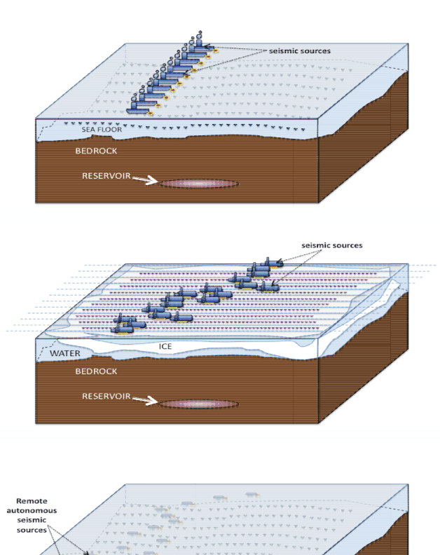
Some limitations in current and conceptual time-lapse seismic applications can be overcome by simultaneous-shooting. First, by acquiring time-lapse data sets with multiple seismic sources, we can limit acquisition time and cost, and therefore acquire more data sets at shorter time intervals. Sufficiently small survey intervals will enable quasi-continuous monitoring of changes in reservoir properties. Other methods for quasi-continuous monitoring have been suggested (Arogunmati and Harris, 2009). Secondly, because we can account for differences in survey geometries during imaging, repetition of survey geometries is unnecessary. Furthermore, because of its high efficiency, simultaneous-shooting can be used for seasonal time-lapse seismic data acquisition in areas with short acquisition time-windows (Berkhout, 2008). Depending on operational limitations, an arbitrary number of seismic sources can be used for each survey. Figure 1 illustrates some scenarios where simultaneous-shooting concepts can be utilized.
There are two discrepancies in time-lapse seismic data sets recorded with multiple sources, namely, geometry and shot-timing non-repeatabilities (Ayeni et al., 2009). As mentioned above, geometry non-repeatability is a result of differences in acquisition geometries for different surveys. Shot-timing non-repeatability between different surveys is a result of mismatches in their relative shooting times. Neglecting survey geometry and shot-timing repeatability during acquisition ensures time and cost efficiency. However, if not accounted for, these two discrepancies will degrade the resulting time-lapse seismic images. Because conventional imaging and time-lapse processing methods are inadequate to account for such discrepancies, we propose a joint (global) least-squares imaging approach.
Least-squares migration/inversion can improve structural and amplitude information in seismic images (Kühl and Sacchi, 2003; Plessix and Mulder, 2004; Nemeth et al., 1999). Direct imaging of simultaneous-source data sets using least-squares migration/inversion methods has been discussed by previous authors (Ayeni et al., 2009; Dai and Schuster, 2009; Tang and Biondi, 2009). In this paper, we formulate time-lapse imaging of simultaneous-source data sets as a regularized joint least-squares problem. By avoiding separation of the recorded data into independent records, we reduce the data volume and processing cost. For each survey, we model the acquisition experiment with a phase encoding operator and the recorded shot-receiver geometries and relative shot-timings. We assume that the velocity and structural dips are known and that they change linearly between surveys. In addition, we assume that for each survey, the shot-receiver positions and relative shot timings are known. Finally, by including structural and temporal constraints in the inversion, we obtain geologically plausible time-lapse seismic images.
First, we consider the phase-encoding representation of simultaneous-shooting. We then introduce a joint inversion framework for simultaneous-source time-lapse data sets. Finally, using fifteen data sets from a 2D numerical model, we show that our method can give high quality images of reservoir property changes.
|
|---|
|
examples
Figure 1. Some conceptual applications of simultaneous-shooting for ocean bottom cable/seismometer acquisition (top), Frontier (e.g. Arctic) data acquisition (middle), and remote autonomous data acquisition (bottom). [NR]. |
|
|
|
|
|
|
Seismic reservoir monitoring with simultaneous sources |