Next: Edge Detection
Up: Applications
Previous: Applications
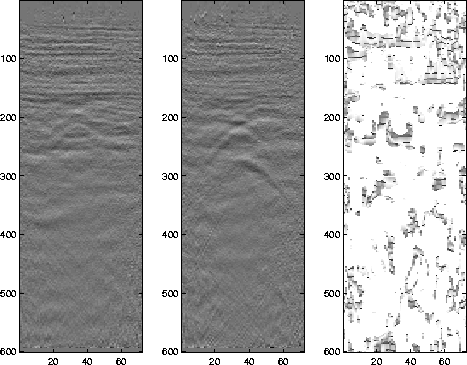
One application for this procedure is assessing the temporal variation
of time-lapse images. When
seismic data are acquired in the same location
at different times, disparity estimation can be used to visualize changes in the
subsurface caused by compaction or fluid flow. This was done with
three migrated images from the Duri Field in Indonesia that were collected over a 20 month period in
the Duri Field of Indonesia. The
original images Lumley (1995) are shown in
figure ![[*]](http://sepwww.stanford.edu/latex2html/cross_ref_motif.gif) with the magnitude of the disparity between the
images. The magnitude of the disparity offers very little information
for this application. The vector representation,
displayed in figure with each vector
scaled by 2, however, better accentuates the change providing useful
information. Although it is hard to
distinguish by looking at the migrated images, there are subtle changes
that can be seen. The left edge of the hump near the center of the
image increases slope from the left panel of figure to
the right. This slight change is detected by the image disparity
algorithm and can be seen with downward pointing arrows near that have
been circled in figure , corresponding to the left
slope of the hump. This may be related to the insertion of an
observation well near that location. The arrows do distinguish
changes throughout the image, but it is very difficult to tell if
these correspond to real changes, noise, or some slight variation
caused by a change in acquisition.
lapse
with the magnitude of the disparity between the
images. The magnitude of the disparity offers very little information
for this application. The vector representation,
displayed in figure with each vector
scaled by 2, however, better accentuates the change providing useful
information. Although it is hard to
distinguish by looking at the migrated images, there are subtle changes
that can be seen. The left edge of the hump near the center of the
image increases slope from the left panel of figure to
the right. This slight change is detected by the image disparity
algorithm and can be seen with downward pointing arrows near that have
been circled in figure , corresponding to the left
slope of the hump. This may be related to the insertion of an
observation well near that location. The arrows do distinguish
changes throughout the image, but it is very difficult to tell if
these correspond to real changes, noise, or some slight variation
caused by a change in acquisition.
lapse
Figure 6 Two images from the same
location at Duri Field at different times. Left:The
magnitude of the change relative to the
first image.


 veclapse
Figure 7 The disparity as a vector plot,
sub-sampled by 2 in the x direction and 12 in the y direction.
Next: Edge Detection
Up: Applications
Previous: Applications
Stanford Exploration Project
4/5/2006