 Tresidder Peak
| Summary
| Image Gallery
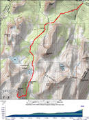
| Trip Map
- Date: June 16, 2002
- Route: Attempted Tresidder Peak's south arete via undocumented(?) south face.
- Approach: 10 miles round trip, 2500 ft. elevation gain. Climb: 2 pitches, bailed after first. Max difficulty: 5.6-5.10(?).
|

Click Here
| 
Click Here
| |
Tresidder Peak, prepare to be climbed...
...or so my internalized battle cry went. Before I cared much about climbing, we had been
stymied in 1999
on an attempt to climb Tresidder Peak's north arete. Fast-forward to 2002. Armed with a new 60-meter
rope, a fledling rack, and the false confidence bred by a few successful sport climb leads, I vowed to
"bag" Tresidder.
Eight hours before we broke trail, however, our plans were quite different. We left Palo Alto thursday night,
planned to do the walk-in thing at Camp 4 in Yosemite Valley. Kim had a couple friends who were scheduled to
meet us on friday, so we had to have a normal campsite. We planned to do a day climb of Mount Starr King on
Friday, hang out with the friends in camp, then hit Tuolumne Meadows for an undetermined day of hiking or
climbing. While our plans weren't as well-laid as they could've been, we were unprepared just how scrambled
they would become!
Camp 4 full?!?
Full on a thursday? Shit. I suggested that we squat somewhere along the Glacier Point Road, so that we'd
get a quick start on Starr King in the morning. But since we had to have a normal campsite, off to Tuolumne
Meadows we went. Most of the campgrounds along Tioga Road, like Yosemite Creek campground, are self-registration
campsites, and do not accomodate RVs, so we assumed that we'd soon be sleeping soundly in a comfortable
campsite. Alas, none of the campsites on Tioga Road open until
the end of June. So at 1:30 a.m., after six hours on the road, we found ourselves bedding down in the back
of my truck, which was parked on a slanted parking spot in the Tuolumne Meadows wilderness permit station.
Kim called her friends and told them not to bother coming up.
It gets even better! Although we did not have our large packs, we had almost all of our camping gear, so
Kim wanted to get a backcountry permit for Cathedral Lakes, so we could salvage the trip with some climbing
and relaxing in the Cathedral Range. We did pretty well in the morning; second in line for permits. As luck
would have it, the chump in front of us picked up three spots for Cathedral Lakes, leaving our party of two
with one permit. The idea of trying to avoid rangers by walking separately, with one person carrying the
camping gear, was simply too much for me. "$%^& this bull$%^&. Let's go climbing."
Finally...
...we were on the trail by 09:30 or so. The John Muir Trail was pretty clear of snow at the lower elevations,
but became pretty swampy in spots, especially near Upper Cathedral Lakes. As I surveyed the muddy mess and
the mosquitoes, my mind drifted back to the three guys who beat us out for a backcountry campsite...enjoy the
camping, assholes!!! Ha ha ha! Near Cathedral Pass, the snow on the trail became thick and pervasive enough
to mask the trail, though it was pretty firm, and the route finding anyhow obvious. Tresidder's north ridge,
which we had used for access in 1999, was covered by a thick, steep snowfield near the top, so we elected for
the "standard" route, which leaves the JMT at 9800 feet, and ascends to the saddle between Tresidder and
Columbia Finger. This easy cross-country route is quintessential High Sierra hiking, over endless low-angle
granite slabs. We elected to take a direct route to the base, by scrambling over class 3 boulders, instead of
an easier path up a long snowfield.
Bob Burd had gotten his initial motivation to
climb Tresidder
from my earlier failed attempt. He made a gutsy free-solo ascent of the south arete, and though I remember that
his trip report boasted an excellent route description, I neglected to bring it with me or read it in detail
before our trip. After all, the main course of our visit was going to be Starr King! So in finding the route,
I was effectively on my own, since in true form, Secor's description was...minimal: "The south summit is the
high point, and the south arete is class 4."
I scouted the prominent south arete
from the southeast,
and quickly decided that a direct ascent of the east face was out of the question. Upon seeing the
south face
of the south arete, I decided that this was the way to go. After all, this was supposed to be "class 4". Accounting
for sandbags, I figured that this could mean anything between actual class 4 and 5.4.
The real climbing starts on top of a large boulder, but I anchored Kim below the boulder, since it offered the
best vision of the climber. Although quite light in color, the granite here was a bit crumbly. Rather than
chickenheads and knobs, sharp feldspar crystals jutted out of the rock, providing good, if a bit unstable
footholds. From the base, the route is very foreshortened. What looks like a 40-foot ascent is
probably closer to 80,
with a lot of rope wasted on horizontal movement. While in the aggregate, the route is slanted
at 45° or so, if you look closely, it is made up of near-vertical blocks.
From the base boulder, the climbing immediately felt harder than class 4. I marginally protected a
groundfall with a micro-nut, then began stemming my way up a 25-foot dihedral. One side of the dihedral
crumbled under foot pressure, while the other was slick and polished. I placed a wobbly hexcentric in
a crumbly, untapered crack, praying that it would hold as I gently worked my way up the rock, tenuously
glued to the surface only by the counter pressure I applied with my four limbs.
Eventually I was able to reach a good anchor point, but I had a problem: my gear had almost run out!
Medium nuts seemed most useful, and my tiny rack contained only a couple after I had anchored Kim to
the rocks below. My gargantuan size 10 hexcentrics seemed to mock me with their uselessness as they
loudly clanged together. Though I was probably only 40 feet above the ground vertically, I decided
to belay Kim up from a
decent anchor point.
From the anchor, things looked even harder. Straight up, nothing but overhanging chockstones and
thin hand cracks. I peered over to the east face, and it looked even worse. After a short consultation
with Kim, the order was given to abandon ship. Making unsweetened lemonade from lemons, I tied a runner
around a convenient chockstone and added a biner to make a pretty good rappel anchor.
We went "around the corner" from the base of our climb to the west and ascended some class 3/4 slabs
to attain the summit ridge.
From there,
we took in
panoramic views
of our surroundings, and unfortunately, also views of a pretty intimidating traverse to the summit.
It didn't take much debate to decide to throw in the towel. We quickly descended the shallow snowfield
to rendezvous with the JMT, but not before taking in wonderful
views of Columbia Finger and the Clark Range,
not to mention of
mean ole' Tresidder,
which doesn't seem to want us on his summit.
On the long drive back home, we remarked that getting tangled in red tape and not making the summit can
still be pretty fun!
© 2005
, Stanford Exploration Project
Modified: 11/18/05, 13:53:04 PST
, by morgan
Page Maintainer: morgan `AT' sep.stanford.edu


