Stanton Peak/Virginia Canyon
| Summary
| Image Gallery
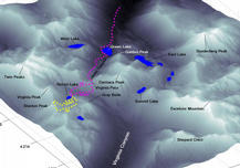
| Trip Map
- Date: June 30-July 1, 2001.
- Route: Return Lake (Virginia Canyon) via Greek Creek trail, Virginia Pass. Dayhike climb
of Stanton Peak.
- Total distance: 20 miles.
|

Click Here
| 
Click Here
| |
This trip realized a few "firsts" for Kim and me. Our first overnight backpack of 2001. Our first
climb up from the Eastern Sierras. Our first exploration of the northern sector of Yosemite. Needless
to say, I'd been in a state of giddy anticipation for the entire week leading up to this trip, poring over
topographical maps, Secor's book,
and other peoples' trip reports. Our goal was to climb to Virginia Pass via Glimes Canyon, cross the
upper reaches of Virginia Canyon, and then make camp above Return Lake.
Wanting solitude, we decided to hike far from Tuolumne Meadows, and quite randomly, I decided that the
high region near Virginia Peak, between Virginia and Spiller Canyons, would make a great camp spot.
We drove over Sonora Pass on Highway 108, and reached the ranger station in Bridgeport around 8:30 am.
Rather than starting our hike right away, we ate a hearty breakfast at the Bridgeport Inn. The 8-mile dirt
road between Highway 395 and the Green Creek trailhead is washboardy, but definitely passable by small
passenger cars. By the time we started hiking at 11:30, we knew a hot day was in store. Considering that
we were on the dry side of the Sierras, we were amazed by the lushness of the many meadows. If it hadn't
have been for the mosquitoes, we would have spent more time enjoying the beautiful flora.
After 4 miles and about 800 feet of climb along a well-maintained (avoid the horse crap!) trail, we
came to a fantastic vista of Green Lake. The little, shallow High Sierra lakes are nice, but I always
find myself captivated by the big, deep ones, like Greek Lake. The mystery of this lake,
combined with the stunning ruggedness of the surrounding peaks, make this spot an unforgettable one.
The geology is quite similar to that of
Bloody Canyon:
brittle, shattered metamorphosed sedimentary rocks on the edge of the Sierra Nevada Batholith. While
the multihued mountains fill the color spectrum of your film better than the usual gray granites, these
peaks do not appear inviting to climbers, with their rotten, talus-covered slopes.
On Forest Service maps, you will
see an "Secondary Trail-Unmaintained" passing up Glines Canyon to Virginia Pass. On USGS maps, you see
nothing. Secor describes
this trail as a "good use trail". Truth be told, it is pretty good in most spots, but a few places merit
a detailed description. The use trail begins at the sign for East Lake and West Lake. Veer to the left
and descend along the trail to the lake level. Follow the trail through the marshy, horribly buggy
northwest corner of the lake. The trail follows the west shore of the lake and becomes sketchy. You
will have trouble finding it in the forest, but remember: the trail follows the west shore and turns
west to follow Green Creek up Glines Canyon. Above the lake, the trail improves in quality and climbs
fairly steadily to Virginia Pass; 1500 feet in 2.5 miles. Directly before Virginia Pass, at 10,200 feet
is a marshy meadow. You may lose the trail here, but you need only shoot toward your goal, Virginia Pass,
a notch at the south end of the saddle. In summer, the pass is an easy scramble. Covered in snow, it
would prove more challenging, but the slope angle rarely, if ever, exceeds 30 degrees.
The views from Virginia Pass were superb, most notably of Virginia Peak, Shepard Crest, and into the
distance toward Tuolumne Meadows. I was suprised to clearly make out
Cathedral Peak
and Tressider Peak, and especially Half Dome.
Once over the pass, a trail continues down the other side, and drops you into Virginia Canyon at an elevation
of roughly 9,800 feet. However, since our goal was high above Virginia Canyon, we decided to take the advice
of Secor and other reports, and traverse the west-facing slope below Virginia Pass. It is a fairly
straightforward, if tedious route, over mediocre dark gray rock, with some class 2 spots. Once down from
the ridge, we crossed the high meadows at the head of Virginia Canyon, but found ourselves slipping, sinking,
and sliding over the marshy ground. On our way out the next day, we took the trail up to Virginia Pass.
Other than being hard to find from below, I now recommend the trail over the "shortcut" that we took.
Physically exhausted from the climb and mentally exhausted from the added stress of cross-country travel,
we decided to make camp at Return Lake around 5 p.m., five and a half hours after our start. Although the
sun sets well after 8 p.m. this time of year, the imposing shadow of Virginia Peak cut off our direct sunlight
at 6:30. Still, the temperatures stayed warm this night. We slept quite comfortably in our tent with no
fly and all windows open. I thought of bringing my fly fishing gear along, but was glad I didn't when I couldn't
discern any fish life in Return Lake, even though the lake looked deep enough not to freeze solid.
We slept comfortably, and awoke around 6 a.m. to climb Stanton Peak (11,695'). The sun was already over the
mountains to our east by the time we started climbing at 6:30. We took a slightly circuitous route, due south
from Return lake, up a gully, then southwest toward the saddle between Stanton Peak and the unnamed 11,450'
peak to its south. The climbing here is a straightforward boulder-hop over solid, low-angle granite blocks.
From the saddle at 11,300', we ascended the last 400' to Stanton Peak's summit along the south ridge. Though
the ridge looks like a knife-edge from below, the rock was fairly solid and the exposure mild. We reached the
small summit block around 8 a.m. and admired impressive views in every direction. Especially impressive was
Whorl Mountain, a 12,000' knife-edge across Spiller Canyon. To the south, Mount Conness, as always, dominated
the view. The Cathedral Range greeted us like a good friend. Mount Lyell's glacier...Half Dome...cool stuff.
Surprisingly, we could not see Return Lake, due to a false summit which blocks the view. Because of the false
summit, we could also not judge the quality of the north ridge route. I believe the false summit has about a
pitch of tough climbing. The standard route up Virginia Peak starts by ascending "Stanton Pass", the saddle
between Virginia and Stanton Peaks.
Our descent took a more direct route, down a route of varying quality. If you don't like loose scree mixed with
sliding 50 lb. rocks, I would descend the south ridge route that we ascended. We ate a breakfast of oatmeal
and tasty coffee, packed up our camp, and hit the trail by 10:30 a.m. This time we wanted to take the trail
from Virginia Canyon to Virginia Pass, but quickly found it nearly impossible to discern. Follow the outlet of
Return Lake, staying on the north--then the east--side of the creek. You will probably spot the trail on the
other (west) side of the creek. Then you should spot some small cairns on your side of the creek. I
believe the slope here is prone to slumping, so the trail quickly disintegrates! All I can say is to head
directly up the slope. Aim for the right (south) side of Virginia Pass, toward a small summit on the southeast
slope of Camiaca Peak. Eventually you will find a trail, which stays fairly coherent to the pass. From the
pass, the return trip was an uneventful, if hot, retrace of yesterday's steps. We limped to the car at 3 p.m.,
four and a half hours after starting, and a full hour faster than the previous day's trip. By 3:30 we were
gorging on hamburgers and ice cream at a restaurant in Bridgeport. We were back home by 9 p.m.
All-in-all, we were highly impressed by our first visit to the Hoover Wilderness and northeast part of Yosemite.
Personally, I like Tuolumne Meadows a bit better, but the remoteness of this place makes it quite desirable.
© 2005
, Stanford Exploration Project
Modified: 11/18/05, 13:53:04 PST
, by morgan
Page Maintainer: morgan `AT' sep.stanford.edu


