 Koip Peak
| Summary
| Image Gallery
| Trip Map
- Date: July 1, 2000.
- Route: Koip Peak from Dana Meadows trailhead.
- Total distance: 20+ miles.
|

Click Here
| 
Click Here
| |
Kim has written a trip report
that is far better than this one, so you may just want to skip mine.
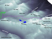
We started at the Dana Meadows (Mono Pass) trailhead (9600') in Tuolumne Meadows around 8 a.m.,
having camped the previous night just over Tioga Pass in the Tioga Lake Campground (illegally,
as Kim's report mentions). I usually make the hike through Dana Meadows a quick one, as the
mosquitoes are particularly agressive here. The stream crossing was not problematic.
We made our way to Parker Pass (11100'), about six miles from the trailhead, a bit before 10:00.
As always, the spur trail is
tough to find.
After cresting Parker Pass, the trail heads toward Parker Canyon, but never descends much below 11000'.
The view is one of contrast, with a placid network of braided lakes in the foreground and the very
rugged Parker Canyon in the background. After three miles or so, Koip Peak and Koip Peak Pass become
visible for the first time. Koip Peak Pass is at the head of a cirque-like feature, bounded by Parker
Peak on the east and Koip Peak on the southwest. The trail climbs about 1000' up unconsolidated talus
on the western slope of Parker Peak, coming to Koip Peak Pass (12200') perhaps three miles later.
As I climbed out of Parker Canyon up to Koip Peak Pass, I was overcome with a feeling of utter
fragility. Geologically, the region is on the edge of the Sierra Nevada Batholith; a hodgepodge
of shattered metamorphic rocks. The last real tree I'd seen was 6 miles and 1200' back. Winds
were strong: sustained 20-30 mph, and gusting to 50+mph. Koip Peak Pass is a saddle between the
gently-sloping shapes of Koip Peak (12960') and Parker Peak (12800'). The lack of vegetation on
either makes it difficult to get a sense of scale, and adds to the mystique, making them seem
even more monolithic.
To be honest, I wasn't overjoyed with the thought of climbing Koip Peak. The slope looked like
nasty talus, which I didn't feel like fighting. But in fact the rocks are fairly well-consolidated,
making travel pretty easy. Indeed, this climb is rated class 1. I did the last 400' to the summit
on a snowfield, but Kim seemed to be making better time on the rocks. We made the summit by 1 p.m.
or so, which means we took about 3 hours to reach the summit from Parker Pass.
Any illusions that this trip
was a fruitless hump were shattered by the view from the summit. To the east: Parker Peak, and
much further away, the truly monolithic White Mountain Range near the Nevada border. To the
northeast, blue Mono Lake, and the red, metamorphic Mts. Lewis, Gibbs, and Dana. To the northeast:
Tuolumne Meadows, Mt. Conness, and even the bottomless Grand Canyon of the Tuolumne River.
Kuna Peak (13000') is a short hike to the west which we didn't take, but I'm sure the view of Lyell
Canyon and Cathedral Range are spectacular. The view to the south took the cake. Nearby was Koip
Crest and Blacktop Peak - incredibly foreboding crags. Alger Lakes nestled in a valley 1500' below.
In the distance, the Ritter Range, and much further south, the peaks at the north end of Kings
Canyon NP. An endless expanse of the most rugged peaks, all interspersed with late spring snow coating.
We lingered on the summit for quite a while, since the wind was actually less intense than on the
trail to Koip Peak Pass. We were the first party to sign the register for nearly a month, but close
on our heels, another party of two dayhikers followed my tracks up the snowfield to the summit.
We ate lunch at Koip Peak Pass and got underway by 2:30. I think we were both ready to stop hiking
by the time we reached Parker Pass at 4 p.m., but alas, we didn't make it to the car until 6:30.
By all accounts, a memorable trip. Unfortunately, my photographic journal of this trip doesn't
adequately conjure up the images I witnessed firsthand...
© 2005
, Stanford Exploration Project
Modified: 11/18/05, 13:53:04 PST
, by morgan
Page Maintainer: morgan `AT' sep.stanford.edu


