 Clouds Rest
| Summary
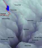
| Image Gallery
| Trip Map
- Date: July 15, 2000.
- Route: Clouds Rest dayhike via Sunrise trailhead
- Total distance: 14+ miles.
|

Click Here
| 
Click Here
| |
Grammatically-astute visitors probably think that the people who named "Clouds Rest" don't know how
to use the possessive form of a noun. In actuality, the original name was probably either
"Cloud's Rest" or "Clouds' Rest", depending on how many clouds tended to rest there. Turns out that
USGS removed all apostrophes from placenames from its maps, exactly for what reason I don't know.
A committee was probably required to make that decision, at a taxpayer cost of $1000x???...
We drove up to Yosemite on Friday (7/14) night, enduring the usual traffic irritation.
I am generally skeptical of the "leave friday/hike saturday" approach, since it doesn't really
bother me to leave at 4 am. Kim, however, is bothered by the 4 am part, so we are still
finding the best approach. Our campspot for this trip was Yosemite Creek Campground, about halfway
between Crane Flat and Tuolumne Meadows. It is first-come-first-served, costs only $6, and is quite
nice. The downside lies in the fact that the campground is 4 miles from Tioga Road, at the end of
a very windy road. But this cloud is lined with silver, since the road is effectively inaccessible
to RV's. In any case, we arrived at 1:15 am(!), but had no trouble finding a nice campspot and
settling to a relaxing sleep in the balmy 50-degree night. In closing the camping discussion, I
wholeheartedly recommend the Yosemite Creek Campgound if you are arriving friday night and don't
want to camp illegally (funny, but most "illegal" campers are far lower-impact than "legal" campers).
Much better than the place we stayed last trip;
100 feet from Tioga Road, $11/night.
We had to first drive to the Dana Meadows trailhead to retrieve some personal items left in a bear
box from our Koip Peak trip, so we ate a nice breakfast at the
Tuolumne Meadows grill, then stopped at Tioga Pass for a quick hike to Gaylor Lakes. It proved to
be a great warmup - 600' climb in a half mile or so. Mosquitoes were voracious in this region, as
they were in most other spots around Tuolumne Meadows. Still, the scenery here tempted me to plan
a future trip. I've always wanted to climb Mount Conness, and an approach from Tioga Pass would be
nice, since it starts at 10000'.
After the initial interruptions, we set forth from the Sunrise trailhead around 11 am. The trail
dawdles aimlessly through unspectacular meadows for 1.5 miles or so, then begins to climb in earnest,
gaining 1000' in a mile or so. Sadly, after cresting the ridge at 9200', the trail quickly loses 300',
then winds through relatively flat forest for another 2 miles. On that irritating descent, we were
passed by a backpacker who cockily dismissed us with a "see you at the top" when we told him we were
on the way to Clouds Rest. The last 1.5 miles of the trail are
quite steep, gaining about 800'. The trail disappears on the knifelike ridge of Clouds Rest itself,
giving way to a fun boulder-hop. "Exhiliarating Class 2"? The closer one gets to the top, the more
apparent is the majesty of the panorama from this point. From the top, the view is nearly incomparable:
Half Dome/Yosemite Valley to the west; the 5000'+ drop into Tenaya Canyon to the north and west;
the Matterhorn spires at the northern boundary of Yosemite; mighty, omnipresent Mount Conness to the
northeast; Mts. Gibbs, Koip Peak, Lyell and the Ritter Range to the west; and most impressively, Mt. Clark
and the Clark Range to the south. The weather was perfect: 65 degress, light cloud cover, and no wind.
We had a nice conversation on the summit with a Caltrans geologist, among the 50-or-so other people who
occupied the summit with us! And most humorously, we'd been on the summit for about a half hour when Mr.
"see you at the top" arrived! We made pretty good time, arriving at 2 pm, for a 3 hour trip.
Usually, I find that I see many new things when I retrace my steps, but not this time. I think the
extraneous weight of my pack (about 20 lbs.) was beginning to take its toll. I packed a tripod, but forgot
the attachment that would have actually allowed me to use it with my camera. I also packed my entire
camera bag, complete with three extra SLR lenses and a flash - none of which I ever used! The aforementioned
300' ascent to the ridge at 9200' really hurt. [Ed. note, 17 June 2002: It didn't help that
I was out of shape!] Our return trip took about 2h35m. We soaked our sore
feet in Tenaya Lake and rinsed off a motley layer of dust, bug repellent, and sunscreen, then drove home
to San Bruno.
© 2005
, Stanford Exploration Project
Modified: 11/18/05, 13:53:04 PST
, by morgan
Page Maintainer: morgan `AT' sep.stanford.edu


