 Bloody Canyon
| Summary
| Image Gallery
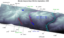
| Trip Map
- Date: September, 1999.
- Route: Sardine Lakes via Mono Pass
- Total distance: ~11 miles.
|

Click Here
| 
| |
TopoZone Map
Like so many times in the past, we set forth from the Dana Meadows
trailhead (9689') after obtaining wilderness permits. This part of
Yosemite provides the easiest road access to the 10,000 foot-level
in the entire Sierra Nevada if you're coming from San Francisco.
At the trailhead, Kim and I flipped a coin: heads and we would go
up to Parker Pass, tails and our destination would be up and over
Mono Pass and into Bloody Canyon. It was tails. The following year,
however, I got my chance to explore the Parker Pass area on our long
dayhike to Koip Peak.
The first three miles (before the fork in the trail to Spillway Lake)
is relatively placid, traversing beautiful -- but mosquito-ridden --
Dana Meadows before rising into a mature alpine forest. The last two
miles to Mono Pass are fairly strenuous with a heavy pack, but
straightforward nontheless - a nice warm-up. If you want to catch the
trail to Parker Pass, the fork is not marked with a sign. Instead,
look for two small cairns by the side of the main trail. If you see
an abandoned cabin on the right (south) side of the trail, don't be
fooled by the small spur trail -- you haven't gone far enough yet!
Geologically, the area around Mono Pass is quite interesting. Nearly
all of the exposed rocks Sierra Nevada range are either intruded granitic
rock from the Sierra Nevada Batholith, or remnants of recent volcanic
activity. Outcrops of metamorphosed sedimentary rocks are rare, and
are often found as "roof pendants", hanging from the tops of high granite
peaks. The 10-20 square mile area surrounding Mono Pass is a notable
exception. The rocks belong to the so-called "Shoo Fly Complex", and
were emplaced in the Paleozoic era, during which time a shallow inland
sea covered the region. In the ensuing years, the rocks were heavily
metamorphosed by heat from Sierra Nevada Batholith as it bubbled up from
the Earth's Mantle, and also from tectonic stresses.
These rocks fracture much more jaggedly than the ubiquitous granites,
giving the Mono Pass area a truly unforgiving feel. At least theoretically,
precious metals precipitated out of the superheated water solution trapped
along the batholith boundary, as evidenced by the extensive, but
long-since-abandoned mining infrastructure in the area. Somewhat
surprisingly, none of the mining operations exploring such environments
in the Sierras ever had much success. Hike south from Mono Pass along a
well-worn trail to see some nicely preserved equipment.
Bloody Canyon is spectacular, though not unlike many other glacial valleys
on the eastern slope. The monotonously steep gradient is terraced in only
two spots, leaving Upper and Lower Sardine lake. We set up camp on the
eastern end of the former lake. Upper Sardine Lake (10,400') is relatively
shallow, and judging from the dearth of fish life, probably freezes solid in
the winter. On the other hand, its larger, and much, much deeper cousin,
Lower Sardine Lake (9900'), holds an agressive population of surprisingly
large Brook Trout.
Unfortunately I forsook my fly rod for a tripod and camera, else we'd have
surely fattened up on the succulent pink meat of a 15-inch Brookie! The
late afternoon surface-feed was stunning - I could easily see the eastern
edge of the lake boiling with action from over a quarter mile away.
Further down the valley is Walker Lake (7956'), surrounded on three sides
by considerable lateral and end moraines, in the classic teardrop shape.
And finally, the canyon opens up for a great view of Mono Lake, 4000 feet
below.
The name "Bloody Canyon" is certainly striking, but I had no clue as to
the etymology. "skutumpah" on the Yahoo!
"yosemitehikes"
club sheds some light on this issue:
"Regarding the name "Bloody Canyon," I wouldn't doubt that the rubicundity of the rocks is
part of it. But I think that bloodletting is part of the name too, having recently read
A Journal of Ramblings Through the High Sierra...
by Joseph LeConte. It's a diary of a camping
trip in 1870 (yes, 1870) taken on horseback by Prof. LeConte of UC Berkeley and 9
undergraduate students. They rode to Yosemite, where they met up with John Muir who
happened to be there and accompanied them over Mono Pass, through Bloody Canyon and
down to Mono Lake. I had assumed that he was writing about Tioga Pass and Lee Vining
canyon but now I see I was in error. Anyway, the point is that LeConte writes that the canyon
got its name from the damage the sharp rocks inflicted on the ankles of the unfortunate
horses who traversed the canyon with miners and others. His own horse didn't fare so well
in the canyon either."
Our trip coincided with a full moon, so we did some night photography.
I hoped for a crystal clear view of an illuminated Mono Lake, but a haze/fog
layer turned Mono Valley into a luminous white soup bowl on the time
exposures. Still, the effects are interesting. We actually made it up
for one of the more memorable sunrises in my recollection, though the
mosquitoes were right there with us! Thank God for the mosquito headnet...
Quick hike back to the car and a noontime swim in Tenaya Lake before the
drive home...
© 2005
, Stanford Exploration Project
Modified: 11/18/05, 13:53:03 PST
, by morgan
Page Maintainer: webmaster `AT' sep.stanford.edu


