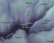
 North Dome
| Summary
| Image Gallery
| Trip Map
- Date: November 25-26, 1998.
- Route: North Dome via Upper Yosemite Falls trail. Return to valley via Basket Dome trail.
- Total distance: 22 miles.
|
Click Here
| 
| |
Day 1
We began our trek at 9:00 on Thanksgiving morning, 1998, from the
Upper Yosemite Falls trail. The route is fairly strenuous, especially with
a pack, as it climbs 2600 feet in 3.5 miles. Since I was traveling with two
Frenchmen (Antoine Guitton and Olivier Meynier), it should
come as no suprise that I carried two bottles of wine in my pack's
side pocket. Although the extra load became quite burdensome by the
time we reached the seemingly endless section of switchbacks near the top,
having the wine was nice. Although for winter trips, I recommend white
over red, unless you like the latter chilled! By noon, we
took our lunch on the bank of Yosemite Creek.
Only a short portion of the eastward hike is on the valley rim, and
it is mostly an unspectacular hump through the alpine forest. An
average amount of snow coated the northern slopes, but not enough to
make me long for my snowshoes, which lay unused in the bed of my truck.
Near the close of day we arrived at our campspot on North Dome, but we scarcely had
enough time to properly set up camp and photograph the fantastic surroundings.
A storm (some snow, mostly wind) ravaged our unprotected camp that night,
making it tough to sleep, and very nearly blew my tent down at one
point.
Day 2
We awoke to a pervasive grayness, with snow flurries to boot. The trail
became snow-covered on the ascent to Indian Rock, and we struggled for the
next five miles or so to keep it in our sights. On the previous
day's hike, Antoine and Olivier laughed at the Forest Service's practice of
simply cutting notches in trees that fall across the trail. As we struggled
through thick, snow-covered forests, however, these artifacts proved
indispensible as trail markers. The snow was deep and fairly thick in
Snow Creek Valley, and I began to rethink my decision to leave the snowshoes
behind.
As the trail turned southward and descended, the snow eventually thinned,
and we descended into the valley
via the Snow Creek trail. On the drive back, I encountered some of
the heaviest precipitation I've seen in California. Made me
feel sorry for the guys we met going up Snow Creek trail without
proper snow gear. Ouch!
© 2005
, Stanford Exploration Project
Modified: 11/18/05, 13:53:03 PST
, by morgan
Page Maintainer: webmaster `AT' sep.stanford.edu


