 Alta Peak
| Summary
| Image Gallery
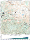
| Trip Map
- Date: October 29, 2001
- Route: Alta Peak Trail
- Total distance: 14 miles. Total elevation gain: 4000 feet.
|

Click Here
| 
Click Here
| |
Alta Peak is the best daytrip I've done out of Lodgepole. If you don't like to read,
the previous sentence should provide enough information to do this hike. The standard route
(among many) up the 11,240-foot summit is via the Alta Peak Trail. Hiking begins in the
dense fir forests around Wolverton at 7400'. After two miles or so, the Alta Peak and Pear Lake
trails diverge. Another mile of climbing on a smooth trail through a thickly-canopied forest
brings you to Panther Gap (8400') and your first views of enormous Kaweah Canyon and the distant,
imposing peaks of the Great Western Divide. From there, you contour gently up the canyon wall,
in the thinning -- but still shade-bearing -- forest. After the trail split for Alta Meadows,
the Alta Peak Trail steepens as it surmounts the final 1200' to the summit. Unbelievably
massive fir trees, merely 50 feet tall, yet with thick trunks more befitting a 200-foot tree,
weather the harsh climate around 11,000'.
Upon reaching the summit, an incredible panoramic view opens up, especially to the southeast.
Countless jagged peaks, belonging to the Great Western Divide, Kaweah Peaks, and probably some
along the Sierra Crest. The slopes to the south drop away over 6000 feet into the drainage of
the Kaweah River. The usual haze makes for strange views to the south and west. For some
reason, the haze is quite photogenic. To the north, you can see Pear Lake, the site of a
backcountry ranger station. Tokopah Valley, in my opinion, is one of the prime examples of
glacial geology in California. If you go to the ridgeline west of the summit, you can see
also Emerald Lake and the arete that separates
it from Pear Lake, as well as the fantastic glacial headwall above Emerald Lake. Tharps Rock
breaks up the hazy monotony of the view to the southwest. This rock horn appears to offer
at least some challenging scrambling, and possibly a technical climb, up its north ridge.
Tharps Rock blocks the view of Alta Peak itself from the Alta Meadow/Alta Peak trail split,
although it is some 600 feet lower than Alta.
Alta Peak's slopes contain a few classic backcountry ski descents. It is rare to find long,
constant, open slopes that are high enough to contain big snow and close enough to a plowed
road for easy access. Starting from the ridgeline northeast of Alta, you can make a big
2200-foot descent to Alta Meadow. Horizontal distance is around 0.85 miles, for a sustained slope
angle of over 25 degrees--perfect for an intermediate backcountry hacker like me, but not
in the middle of the "magic" avalanche range of 25-40 degrees. Since the Pear Lake ranger
station, a common winter backcountry outpost, sits only a mile north of Alta Peak, it is
common to climb up to Alta's northeast ridge and ski back down various routes.
Kim and I climbed Alta on October 28, 2001, a perfect (if a bit smoky) cool fall day, and
most importantly, one day before the year's first winter storm! We started at Wolverton
around 11 a.m. and hiked quickly, reaching the summit at 2 p.m. with a few brief stops.
We farted around on top, eating lunch and taking pictures. When we stepped off the summit
at 2:45, we immediately realized that due to reversion to standard time, darkness would
fall by 5:30 at the very latest. So we busted our butts back and reached the truck at
around 5:05 p.m. So it is possible to cram this one into a half day, but you should
probably bank on 7 hours or more for a round trip.
© 2005
, Stanford Exploration Project
Modified: 11/18/05, 13:53:01 PST
, by morgan
Page Maintainer: morgan `AT' sep.stanford.edu


