
![]()

![]()

![]()
![]()
![]()
![]()
![]()
![]()
![]()
![]()
![]()

![]()
![]()

![]()
|
Recommends... Foghorn Outdoors: California Hiking - By Tom Stienstra and Anne Marie Brown. One of the most useful books we've ever purchased. We've found our favorite Bay Area dayhikes from this book. |
|
Selected Photos...
|
 Sweeney Ridge
|
|
| Summary | Image Gallery | Trip Map
|
|
Click Here
| 
|
Sweeney Ridge is a special place for Kim and me. We live in San Bruno, ten minutes from the trailhead. In the summer, thin wisps of fog dance and swirl over the top of Sweeney Ridge. We'd enjoyed the daily fog display for a year and never thought of hiking up there. That was until we bought California Hiking, a great guidebook.
My first trip to Sweeney Ridge came in May, on a wonderful spring day. Quickly I was treated to undoubtedly the most commanding panorama of the Bay Area since my 1997 arrival. Mount Diablo to the east, Tamalpais to the north, San Francisco Bay, and even the Farallon islands, twenty miles into the Pacific Ocean. Before I thought it could get any better, I came across the irises. Literally an entire hillside just covered with wild irises. I've never seen the equal of that display before or after.
Since then, I've hiked Sweeney Ridge many times. In the morning, at sunset, in the fog, sunshine, and rain. I've watched the fog come in from the ocean at the Pacifica gap. Take a time snapshot of the cloud tops and they resemble an odd, snow-covered topography. Watch this for a while and the topography translates, warps, rises, falls, and finally disintegrates over the airport. The dynamic aspect of Sweeney Ridge draws me back again and again.
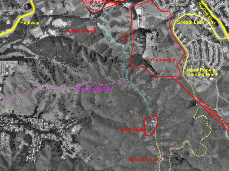
Sweeney Ridge is contained in the Golden Gate National Recreation Area. There are two popular ways to access this area. The first, and I think best, way is to park in parking lot #2 of Skyline College. To get there, go north on Skyline Blvd. (highway 35) if you live on the peninsula. Pass Sneath Lane and turn left at the next stoplight. If you hit Sharp Park Road, you've gone too far. Parking lot 2 is on the south side of the College, near the baseball fields. You'll see signs for GGNRA, and also a hand-painted "Walk in Pairs" sign. My brother-in-law Robert tells me that a serial killer murdered a few people here in the early 80's.
Take a rough, steep trail directly up the hill from the parking lot. After 100 feet, you'll hit a wider gravel road. Follow this trail uphill. Eventually you'll come to a small abandoned guardpost. Strange, until you realize that a US Army Nike Missile (anti-aircraft) base was here for about fifteen years. Apparently this base was a radar station only -- the nearest missile battery was located on nearby Milagra Ridge (picture courtesy of Peter Snowberg). Ed Thelen's Nike Missile Site is amazing. Peter Snowberg's Nike Missile Sites of the San Francisco Bay Area is growing and quite nice if you're interested in finding other Nike sites in the Bay Area. These missiles were presumably rendered obsolete by Russian ICBM's and the Anti-Ballistic Missile (ABM) Treaty, and all batteries inactivated in 1974, only 17 years after initial deployment in 1957. The Nike Hercules missile carried small (2-40 kilotons) nuclear warheads, designed to disable incoming aircraft or missiles with an electromagnetic pulse (or directly!). The first guardpost is at an elevation of 930 feet, meaning that you have climbed 230 feet from the parking lot. Unfortunately, you lose nearly all of that hard-gained elevation in the next quarter mile, as the trail drops into a lush gully at 790 feet. The climbing starts in earnest now, as you gain 250 feet of elevation over a well maintained set of stairways. The trail stays fairly level for the rest of the trip, gaining another 250 feet over 3/4 mile. We normally stop at the main Nike Missile base at 1250 feet above sea level, 2 miles from the trailhead.
For slightly out of shape people, this is a great way to push your cardiovascular limits. Others (Kim likes this) will find this a great trail run. The total uphill over a 4-mile round trip is a respectable 850 feet. You can continue along the ridge for quite a while.
Best of all, this hike is barely known! I've seen no more than ten people on the trail, even on the most perfect summer weekends.
The second, and probably better-known point of access is at the end of
Sneath Lane. Turn west onto Sneath from Skyline Blvd. Veer left immediately.
About a mile from Skyline Blvd., you'll come to a dead end and see a small
parking area for the GGNRA. Just follow the road uphill (it's paved).
After a couple miles of steady climbing, you'll hit the Bay Area Ridge
Trail. Turn north (toward the water tower) and you're less than a mile
from the Nike Missile Base. Personally, I don't like this hike nearly as
much as the Skyline College route. Still, done as a one-way trek with
two cars, going from Sneath to Skyline would make for a great run.
|
Department of Geophysics Stanford University |

|


