
![]()

![]()

![]()
![]()
![]()
![]()
![]()
![]()
![]()
![]()
![]()

![]()

![]()
![]()
|
Recommends... Foghorn Outdoors: California Hiking - By Tom Stienstra and Anne Marie Brown. One of the most useful books we've ever purchased. We've found our favorite Bay Area dayhikes from this book. |
|
Selected Photos...
|
 Montara Mountain
|
|
| Summary | Image Gallery | Trip Map
|
|
| 
|
TopoZone map (warning: the map data is incomplete)
Like Sweeney Ridge, this hike is one of our favorites, and another recommended by our California Hiking guidebook.
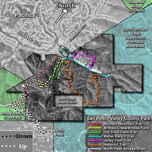
Thanks to plants.montara.com for the great tripmap that I show above. I annotated it with some important information (like north) and added our usual hike. We normally ascend on the Brooks Creek Trail. Montara Mountain is a broad, weathered granite mountain. Because granite is stronger than the weak sediments that make up most of Montara's neighbors, Montara Mountain is taller and steeper. It tops out at around 1900' above sea level. The western slopes of Montara are predictably moist, as they open to the Pacific Ocean. The Brooks Creek Trail heads through some very lush forests -- a true treat for any hiker. The high point of this trail is a viewpoint for a 175-foot waterfall which is a beautiful sight in the spring and winter.
After the waterfall, the Brooks Creek Trail meets the Montara Mountain Trail. The vegetation changes from forest to scrub, with many flowers during spring and early summer. The trail follows a ridgeline at a steady gradient, with many great views to either side. After climbing to the 1200' level or so, the Montara Mountain Trail intersect the North Peak Access Road, which eventually leads to the summit. Here the backdrop turns far more arid for some reason, with little vegetation. Be prepared for a very hot sun during the summer months along the access road. Also, the access road is popular with mountain bikes, so if they bother you, you may not want to bother going to the summit.
To me, the sumit is anticlimactic. Montara Mountain is difficult to see from most Bay Area vantage points. Consequently, you can't see much of the Bay Area from Montara Mountain! In the summer, the summit is hot and dry, and often quite foggy and windblown during other motnths. Radio towers dominate the skyline.
We've always returned by sticking to the Montara Mountain Trail. Amazingly, the backdrop is strikingly different than the Brooks Creek Trail. The last mile or two descend through a dense Eucalyptus forest, making for a pleasant-smelling end to your hike.
If you live in the Bay Area, you've got to do this hike at least once. As I said, don't
bother with the summit. Stop at the Access Road and you've seen the best parts of
the hike. Northern California is known for its microclimates, i.e., huge variations
in climatic and vegetation properties over short distances. This hike is a shining
example of that variation: dense, moist manzanita forests, waterfalls, high coastal
headlands, wildflower groves, eucalyptus forests. I walk away from this hike with
a smile on my face.
|
Department of Geophysics Stanford University |

|

