Quandary Peak (14,265') and Fletcher Mountain (13,951')
| Summary
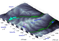
| Image Gallery
| Trip Map
- Date: September 2, 2000
- Route: Fletcher Mountain via Blue Lakes trailhead. Quandary Peak via West Ridge. Descent via Cristo Couloir
- Total distance: ~8 miles.
|

Click Here
| 
| |
TopoZone map
I reached the Blue Lakes parking area before 7:00 am, perhaps the
third party to brave the bone-chilling morning wind for a pseudo-alpine
start. My goal for the day was to climb to the 13,400' saddle which
separates Fletcher Mountain (13,951') and Quandary Peak (14,265'),
climb Fletcher via its southeast ridge, and then climb Quandary Peak
along the West Ridge route.
Alone, I set off quickly, and soon left the Blue Lakes trail for the
use trail that ascends the "hanging valley" southwest of Quandary Peak.
Braided streams and a lack of vegetation render the use trail
indistinct as climbers approach the "headwall" of the hanging valley.
Many class 2 routes to the Fletcher/Quandary saddle exist, but in the
dual spirit of laziness and adventure I did a little scrambling along
the way.
I stood at the Fletcher/Quandary saddle at 8:30, and by 8:45 I was on
Fletcher Mountain's summit, after some tedious class 2 scrambling over
loose blocks and boulders. The views were great today. Clear as a
bell in every direction. Quandary Peak especially looming to the east,
with a quite fitting name, as I ponder the tougher climbing on Quandary's
West Ridge. A large molybdenum mine (the Climax) sits near the top of
the pass on highway 91, which runs from Leadville to Frisco. Although
undeniably colorful, the enormous tailings ponds are somewhat unsightly,
especially in a dry year like this one. I was anxious to set forth
for Quandary Peak, so I lingered on the windy summit until only 9:00 or
so, and quickly returned to the Fletcher/Quandary saddle.
Just above the saddle, there are some obstacles at the 13,400' level,
which I avoided to the south. At 13,500', a rudimentary climbers'
trail magically appears on the north side of the ridge. I could imagine,
with some awe, hardy miners and their mules clambering up this route to
the old mining claims that dot the talus slopes.
The north slope is
well-behaved until 14,000', where the trail ends and the scrambling begins
Between the 14,000' and 14,200' contours on the USGS quad, you can make
out four well-defined towers along the west ridge. The first three
were fairly straightforward class 3 with non-trivial route-finding
challenges. Unfortunately, after a quick look at the fourth tower, I
rashly decided that it looked fifth class, which was harder than I was
prepared to solo. Irritating mistake! I descended about 100 feet
into a steep, amazingly rotten gully, traversed around the fourth tower,
and finally made a painstaking ascent of another equally steep, equally
rotten gully to the east of the fourth tower. This proved to be the
most stressful climbing of the day. After topping out on the main ridge
again, I was greeted by a stunningly exposed traverse on good, solid
rock around the north side of the ridge. One last scramble up the
sidewall of a gully, 50-foot of solid class 3, brought me to within a
short walk to the summit.
The traverse from Fletcher Mountain to Quandary Peak took me longer
than I expected (2 hours), but it was an enjoyable and exhiliarating
climb, aside from the gully episode. Besides, I was in no rush, since
the thunderstorm potential looked small. 15-20 people were on
the summit at all times during the blissful hour and a half I spent
there, and I'm sure that all of them came from the East Ridge route.
People looked at me strangely when they found out that I'd come up the
west ridge route, because the route is basically invisible from the
summit. I guess people fear what they can't see. Anyhow, they looked
at me even more strangely when I started down the "Cristo Couloir",
which is just a fancy word for "straight line path back to the Blue Lakes parking lot".
As the crow flies, this route is a mere mile long, and loses 2600',
although it looks steeper than it is. It is certainly not a sustained
45-degree slope! I did a lot of downclimbing, as much scree skiing as
I could, and a lot of falling on my butt, but I was back to the truck
after a long hour. Done over, I'd have only done this if there
was snow in the couloir, as it would likely make a suitable glissade.
The gully episode hammered home a point for me: class 2 grappling
over truly crummy rock should not be the big adrenaline rush of the
day. Personally, I would rather climb short class 4 pitches unroped
than risk a long fall down a rotten gully. Reluctantly, I might climb
short, easy class 5 stuff unroped, as long as I was helmeted. But
as Roach notes, this decision must be made by every climber individually.
Roped climbing (sport and gym) has helped me know my limitations on
alpine climbs. I recommend this for anyone who aspires to do
semi-technical alpine climbing.
I sent Gerry Roach, author of the famous guidebook
Colorado Fourteeners: From Hikes to Climbs,
an e-mail, asking him some questions about
this route. He sent me a very detailed and insightful reply, in which
he covered not only this route, but also gave some interesting takes on
the California versus Colorado notion of climbing...
Re Quandary West Ridge.
This ridge is turning out to be harder than most people expect. It
sounds like you missed a critical up-climb on the 4th tower. My memory
is of crossing the gully, then climbing the SW face of the 4th tower
(Steep but only Class 3). There was a fatality on this ridge a year
ago. A party was using
Dawson's 14er guide
and thought that the West
Ridge was the standard route! Yipes! That's a bad error for a hiker
to make. Some friends of mine were caught up in the rescue. It was a
bad scene. For the record, I always put the standard route first for
each peak and preface its description with, "This is the easiest route
on the peak."
Re Cristo Couloir.
This is normally done with snow in it. We have had a very dry season and
the snow is long gone.
One general comment:
If most of your experience is in California, then you may have already
discovered that the ratings between CO and CA don't line up very well.
CA ratings are harder. I think this stems back to the pioneer days.
Class 5 in CA is where Norman Clyde put on a rope. That's 5.5 or 5.6 by
today's standards. Hence, North Palisade is rated "Class 4" but would
probably get a 5.3 or 5.4 rating in CO today. Our general rule is: If a
climb is rated Class 3 in CA, we take a half rope and small rack.
If a climb is rated Class 4 in CA, we take a full rope and full rack.
Things are a bit softer here in folksy CO. I have a few words about it
all in my front matter.
- CO Class 1 = trail hiking.
- CO Class 2 = off-trail hiking on talus or bushwhacking.
- CO Class 3 = "Hands on" scrambling.
- CO Class 4 = easy climbing.
- CO Class 5 = technical climbing (whatever that is)
Since words fail to define, my real definition is by example, and I give
a list of example climbs. As a guidebook author, I get a lot of pressure
to upgrade some ratings to higher numbers. I have staunchly resisted
this for years as it would only increase the gap between CA and CO
ratings. This is why I invented the rating Class 2+ for "psuedo
scrambling" or "scampering." There are routes in CO that some would
prefer to see tagged Class 3 but I only give it a Class 2+. The plus
sign tells people, "Hey! You're not just walking anymore!" Note that
Quandary West Ridge gets a full blown Class 3 rating. Some here would
prefer a Class 4 rating for this route but it might only get a Class 2
in CA. A general rule in CO is: If it looks like Class 5 ahead, look
around. There is probably a Class 3 route nearby. Few CO peak-bagging
routes require Class 5 climbing. The name of the game is route finding.
After my exciting climb, I headed over Hoosier Pass to Southpark for some
fishing in the upper reaches of the South Platte River. The only
fork with enough water to fish in September is the Middle fork, especially
in years with hot, dry summers, like this one. Like many times in the
past, I fished the Middle fork just north of Hartsel, Colorado, in the
Badger Basin State Wildlife Area. As I tied up, a small thundershower
approached, and I figured that the accompanying pressure drop would
bode well for fishing. Indeed! I tied on a #8 Dave's Hopper and the
surface action begun, which was a bit surprising for 4 p.m. I missed
five or six hits in the first 15 minutes or so, and the last hit was
quite similar--not ferocious. I hooked the fish this time, and the
small, lethargic tug on my line convinced me that all the fish in here
were small. And then I saw her roll! She was far larger than I imagined,
so I mended my line and prepared to fight her for a while. After a
careful 10-minute fight, I dragged her to shore and subdued her
agressively, since I did not have a net. She measured a whopping
25 inches and probably weighed 4-6 pounds. And you better believe that
I ate her! I'm a sucker for the succulent pink meat of a Brown Trout.
© 2005
, Stanford Exploration Project
Modified: 11/18/05, 13:53:01 PST
, by morgan
Page Maintainer: webmaster `AT' sep.stanford.edu


