 Mount Bierstadt
| Summary
| Image Gallery
| Trip Map
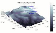
- Date: September 24, 2000
- Route: Mount Bierstadt (14,060') via northwest ridge, starting from Guanella Pass trailhead (11,769').
- Total distance: ~6 miles.
|

Click Here
| 
| |
TopoZone map
September winter storms in Colorado are fairly rare, but not anomalous. I
left Denver around 5:30 a.m., with 3 inches of snow on the ground, but clear
roads. The bridges were a bit hazardous. Snow increased as I progressed
westward on I-70, peaking near the Evergreen exit. But as I went deeper into
the mountains, the temperature rose. I believe the really cold air came from
the north, and the storm was caused by the meeting of the cold air and
warm, moist air arriving from the west. When I arrived in Georgetown around
7:00 am, the roads were clear.
My original goal was to climb Torreys and Grays
Peaks, but you see, I had
already screwed up. The most popular access point to the Torreys/Grays
trailheads are from the Bakerville exit, about 7 miles to the west. I
put on chains and headed up the Guanella Pass road, toward what I thought
would be the trailhead. In fact, a quarter mile after driving toward
Waldorf Mine, I became stuck on a snow-covered rock. The right rear
wheel was spinning freely, since its shock mount was perched on the rock.
After 30 minutes or so, I freed the truck by wedging 2x4's under the
tire, which raised the back end enough so that I could simply drive off.
Discouraged, I abandoned my quest for Torreys/Grays, and instead continued
up Guanella Pass Road toward the most popular trailhead for Mount Bierstadt.
By some accounts, the 3 mile hike from Guanella Pass to Bierstadt is Colorado's
most popular 14'er hike. In spite of its accesibility, the area is striking,
even more so today, due to a fresh coating of white powder. Mount Evans
(14,263'), complete with a paved highway to the top, is roughly 1.5 miles
from Bierstadt, and the "Sawtooth", which is the class 3 traverse connecting
the two peaks, is apparently a classic.
A well-beaten trail immediately descends from Guanella Pass into the drainage
of Scott Gomer Creek, to 11,400' or so. As my entry in the trailhead register
states, I got a 9:23 am start. Hardly commendable, since I'd been on the road
for 4 hours. Until recently, travel through a large area of
scrubby willows in the flats was difficult. Now, a raised wooden sidewalk
makes this trip easy. After crossing the willows, small stakes stuck up
through the snow, marking some type of trail. The going was easy, since I had
at least 3 parties ahead of me to punch steps into the fresh snow. The
markers were visible until the 12,500' level, where they disappeared in the
deeper windblown snow. Winds prevailed from the north today, and the trail
is quite exposed to north winds from 12,400' all the way to the summit.
The weather was exceptional as I started. Clear and windless, with stunning
and strange views for September. As I reached 13,000', things started going
downhill. The slope steepens, and is large rockfall, as opposed to grass.
I punched deeply through into hidden rock crevices, and prayed that I would
not injure an ankle up here. Clouds obscured the sun and that north wind
picked up considerably, blowing large amounts of fluffy powder snow through
the air. My pace slowed considerably, and I wished I'd have brought my
adjustable ski poles with huge powder baskets. Around larger boulders, I
sunk into snow up to my hips, which is quite a feat, since I am 6'8"!
By the time I reached the 13,600' west shoulder of Bierstadt a little after
11:30, winds were sustained in the 25-40 mph range, and the blowing snow
cut visibility to near zero at times. Still, in the fleeting moments of
calm, I was treated to great views to the south and west. Frozen Lake -
unfrozen on this day - lies in the south cirque of Bierstadt, 900' below.
The only thing frozen was the water in my bottle and my eyelashes.
I wasted little time starting toward the summit, hoping that I'd find
some respite among the large boulders along the final ridge. Whenever
possible, I climbed on and over boulders, instead of going around them.
I have no idea what time I made the summit, but that time seemed to
coincide with the worst weather of the day. Looking at my watch meant
exposing skin to the wind, and I'd already tried that with my right index
finger and thumb, with unpleasant results. I took no pictures, signed
no register (couldn't find it among the snow), and basically got off
the peak ASAP.
The descent was brutal. In hindsight, I should have brought my facemask
and goggles, because the blowing snow was quite painful as it impacted my
frozen face. I threaded my way cautiously through the boulder field,
watching another party with poles enviously as they moved quickly here.
To thaw myself out, I increased pace when the trail improved, and made
my car by 2:20 pm. If the 6 mile round trip figure of Gerry Roach is
correct, my pace was only a bit over 1 mile per hour. Winter hiking
demands patience!
Luckily, the roads were totally clear by this time, even at this high
elevation. I drove south over Guanella Pass, intersecting US 285 in
Grant, CO and was home by 4 pm.
© 2005
, Stanford Exploration Project
Modified: 11/18/05, 13:53:00 PST
, by morgan
Page Maintainer: webmaster `AT' sep.stanford.edu


