 N/S Arapaho Peak
| Summary
| Image Gallery
| Trip Map
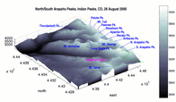
- Date: August 26, 2000
- Route: South Arapaho Peak via East Ridge, attempted North Arapaho
Peak via connecting ridge.
- Total distance: ~12 miles.
|

Click Here
| 
| |
TopoZone Map
I set out for my first Colorado adventure at 5:30 am.
Somewhat arbitrarily, I chose South Arapaho Peak as my
goal. I can't remember exactly why, but the single
biggest reason was probably its proximity to Denver.
South Arapaho (13,400') and North Arapaho Peaks
(13,500') are probably the best-known twins of the
Indian Peaks, a decent-sized range of "13'ers" due east
of Boulder, on the Front Range of the Rockies. They are
visible from most Denver vantage points on clear days.
I started at the Fourth of July Campground at 7:15 am.
Everyone I talked to emphasized just how important it was
to leave early, because compared to the sunny Sierras
weather really is a factor here -- especially the
lightning. I was hoping to be on the trail by 6:30 or so,
because I had no idea how long my adventure would take.
My goal was to ascend South Arapaho Peak, then traverse
the long connecting ridge and ascend North Arapaho Peak.
The weather was cool, and the altitude immediately
apparent, since the trailhead is at 10,150'. A pair of
hikers was kind enough to ration me some sunscreen. I
made good time, but worried that the high altitude,
coupled with the fact that I was recovering from a cold
and hadn't exercised for ten days, might catch up with
me. I made it to the Fourth of July mine ruins (11,150')
by 8:30. From there, the trail becomes rocky and ascends
rather quickly to a saddle at 12,700'. I made the saddle
by 9:15 and took a much-needed water break. I really began
to feel the altitude after 12,000'. On a hike, I'm not
afraid to breathe hard and fast, because I normally recover
quickly. Up here, however, it was much tougher to recover.
I started up the ridge to the summit of S. Arapaho Pk,
and found it to be mostly Class 2 with some short sections
of Class 3 which probably could have been avoided altogether
by better route-finding. Although the mountain was granite,
it was more weathered and perforated by intruding dikes than
the peaks of the Sierras. To the north was a sheer wall maybe
700' high. From the ridge, I had a great view of the Arapaho
glacier. Classic ampitheather cirque, crevasses large and
small (snowfall was light last year), moraines, and even
little icebergs floating in the lake at the glacier's toe.
I made the summit by 9:45 and took some photos.
In the last hour, cumulus formation definitely picked up,
but I did not yet fell threatened. I started off the summit
at 10:00 am, setting out to cross the ridge and climb North
Arapaho Peak, which is a mere 100' higher than South Arapaho.
Because my return trip to South Arapaho would be totally
exposed, I decided to turn back at 11 am, regardless of my
progress.
The ridge was fun. A trail of some sort, complete
with cairns and even orange arrows spray-painted onto rocks,
guided hikers along the easiest path. Still, there were many
sections of Class 3 and even two or three sections of Class 4.
I can never tell exactly how to rate scrambles, but I have a
personal definition of Class 4: easy, but fairly technical
to up-climb, but with an irritating down-climb. After the
last Class 4 section, which was a smooth 8-foot high inclined
wall, it was 10:30. I was about 3/4 of the way to North
Arapaho Peak, but the weather situation had worsened in the
intervening half hour. Thick, dark clouds were
massing on the next range to the south, complete with rain,
lightning, and audible thunder. The storm didn't appear to be
moving toward me directly, but the clouds were defnitely in
the expansion stage. If it had been a matter of simply
descending the peak, I'd have kept going. But to get to safety
in this case, I'd have had to traverse back along the tedious
ridge, re-ascend South Arapaho, then descend along the first
exposed ridge back to the saddle at 12,700'. So I bugged out
and headed for cover...
It took me 20 minutes to return to the summit of South Arapaho,
and by that time, I could see that the storm was going to miss
me. I suppressed temptations to try for North Arapaho again. I
I made it to the saddle at 12,700 by 11:00, and was back to the
car by 12:30. I felt kind of ill on the way down (slight nausea,
headache, muscle pain) and my sinuses started reminding me that
they weren't fully healed yet. I saw many, many people going up,
in spite of the worsening weather, so I wondered if I hadn't
been overly cautious in my decision to come down. My caution was
validated as I reached my car, however, because the rain started
to fall, and got quite heavy as I drove away.
© 2005
, Stanford Exploration Project
Modified: 11/18/05, 13:53:00 PST
, by morgan
Page Maintainer: webmaster `AT' sep.stanford.edu


