
![]()

![]()

![]()
![]()
![]()
![]()
![]()
![]()
![]()

![]()

![]()
![]()
![]()
![]()

|
Recommends...
|
|
|
| Trip 1: | Up Page Mill Road, Down Old La Honda Road
| Trip 2:
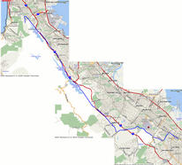
| Mountain View to Pacifica - Peninsula N-S Mega-tour
| Trip 3:
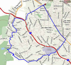
| Up Moody Road, down Page Mill Road
| |
| Summary | Image Gallery | Trip Map
|
|
|
 Click Here 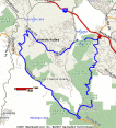
|
|
|
On my Stanford-area Ride Calculator, you can cut-and-paste the following string into the "Your Ride" box for more detailed statistics: -PAI,-PAA,-PAM,+PMS,-SPO,+OLH,-POR,-AAP,-APA,+PAI
| Mile | Action | Comment
| 0 | Page Mill & I280 | Park-and-Ride Get here early--on a nice day you will not find parking after 9.
And besides, you don't want to be climbing the exposed slopes of
Page Mill Road on a 90-degree summer day.
| 3 | Cross Moody Road | Moody Road descends back to Los Altos and seems to turn into El Monte Ave.
This could be a cool, if easier loop. Your altimeter should read 960'. The
climb recently got steep and nasty. Expect this nastiness for the remainder!
| 7 | Road Levels out | The kicker about this road is that is has downhills. Around mile 7 you'll reach
around 2200', and eventually top out around 2300'. That's right, campers, you've
climbed 2000' from the parking lot. Around mile 8, you make your last irritating
downhill, and promptly regain it as you reach Skyline Blvd.
| 9 | Right on Skyline Blvd. | |
 Your altimeter should read 2250'. Continue straight (now Alpine Road), and
you can do some of the classic "Bay-to-Sea" rides. Russian Ridge Open Space
is just across Skyline. We walked/rode our bikes up to Borel Hill (2572'),
took in the views, then continued to the Vista Point Parking lot. Skyline
Blvd. tops out at 2400', but from there it is basically downhill until you
hit Highway 84.
Your altimeter should read 2250'. Continue straight (now Alpine Road), and
you can do some of the classic "Bay-to-Sea" rides. Russian Ridge Open Space
is just across Skyline. We walked/rode our bikes up to Borel Hill (2572'),
took in the views, then continued to the Vista Point Parking lot. Skyline
Blvd. tops out at 2400', but from there it is basically downhill until you
hit Highway 84.
14 | Pass Windy Hill | Open Space On our ride, the fog was frighteningly thick. I rode very fast, in
the hope that the last split second of extra time would prevent me from
getting mashed by a minivan. You'll see cars, fences, and bathrooms
here. It's only another mile to Old La Honda Road.
| 15 | Right on Old | La Honda Road
Turns out that we had no trouble spotting OLH Road. Probably 15 bikers
were congregated on the top.
| 19 | Right to Portola Road | | 
 Be careful on the descent of OLH Road. The top 1 mile is very rough. The
last three are quite smooth, but I find the biggest hazard to be hordes of
climbing bikers on the wrong side of the road! Fearless, they are, since a
head-on collision with a guy
my size would not be fun for a small person.
Be careful on the descent of OLH Road. The top 1 mile is very rough. The
last three are quite smooth, but I find the biggest hazard to be hordes of
climbing bikers on the wrong side of the road! Fearless, they are, since a
head-on collision with a guy
my size would not be fun for a small person.
21.5 | Left on Alpine Road | From the intersection with OLH road, you'll climb from 375' to 600'. Don't
forget to stop at the stop sign! The locals do not like bikers, and on a
busy weekend day, it's not hard to see why. Packs of a hundred or more
bikers run this stop sign en masse. The police are fond of writing $100
tickets. These are moving violations, people, and I don't think the judge
will take much mercy.
| 23 | Right on | Arastradero Road Almost home! Enjoy this open, rolling road and see how fast you can go.
| 25 | Left on Page Mill Road | You're so close!
| 25.25 | End at Park-and-ride | Congratulations on a challenging 25-miler with 2800' of climbing.
| |
| Summary | Image Gallery | Trip Map
|
|
Click Here
| 
|
I promised some online friends of mine that I'd visit the Nike Missile radar site on Sweeney Ridge. So I figured that I could turn it into an epic ride. Epic might not be the right word. Punishing and underestimated are better descriptors. All I will say is that I'm glad I didn't con Kim into coming along on this one (she was out of town). I left Mountain View at 6:30 a.m., reached the Nike base 33.6 miles and 2.5 hours later, spent a half hour there, and took 2.5 hours to limp back to Stanford, where I type this report.
| Summary | Image Gallery | Trip Map
|
|
Sorry...
| 
|
If you're busy or otherwise unable to take a long bike trip, this may be the perfect Peninsula hill-climb. Under 12 miles and 1000 feet of climb, so you're never too far from home, but believe me, the last leg up Moody Road will test the lungs of every biker! Certainly less of a commitment than any of the "normal" hill climbs to Skyline Boulevard (Page Mill, Old La Honda, Kings Mountain), but enough to keep most of us in shape. Traffic is never a serious issue, though it is always preferable to get an early start, i.e., before 8 a.m.
On my Stanford-area Ride Calculator, you can cut-and-paste the following string into the "Your Ride" box for more detailed statistics: -FAE,-ELM,-MDY,+PAM,+PAA,+PAI,+AFP
| Mile | Action | Comment
| 0 | Arastradero Road | & Foothill Expressway You can park at Gunn HS on weekends. Turn left (south) onto Foothill.
| 2.3 | Right on | El Monte Road Continue under IH-280, pass Foothill College.
| 4.0 | Veer left onto | Moody Road This occurs at Foothill College. Moody Road is curvy, narrow, and relatively flat. After a few miles,
you might start wondering, "When does it start climbing???" Answer: Around mile 6.2, at 450 feet elevation.
The remaining 0.5 mile to Page Mill Road climbs roughly 500 feet--an ass-kicker by any standard!
| 6.7 | Right at stop sign | onto Page Mill Road Enjoy 2.5 miles of fast, pure descent. Watch out for some hairpins with gravel and/or
irritating negative bank angle.
| 9.4 | Right at stop sign | onto Arastradero Road This is the stop sign directly before you pass under IH-280. After 60 feet of steep climbing
right away, this road is generally a gentle descent, all the way back to your start point.
| 11.4 | Arastradero Road | & Foothill Expressway Now do whatever it is you have to do today.
| |
|
Department of Geophysics Stanford University |

|