Stanford Crustal Geophysics field trip, 2002
by Jon Claerbout (SEP)
| http://sepwww.stanford.edu/data/media/public/sep/jon/crustal/ | claerbout @ stanford . edu |
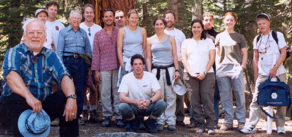
Simon Klemperer, leader of the Stanford Crustal Geophysics group, organized a field trip to eastern slopes of the Sierra Nevada mountains. Adding years of wisdom were George Thompson and Dave Scholl. There were about 15 of us in all.
 We had fun. I'll omit the well known Yosemite highlands
and get to the clear skies of the Nevada rain shadow.
I was awed by the many amazing environments,
places I had previously passed over in ignorance.
My camcorder died at the third outcrop
so all you have is this web page,
organized from north to south to help us find our way back.
We had fun. I'll omit the well known Yosemite highlands
and get to the clear skies of the Nevada rain shadow.
I was awed by the many amazing environments,
places I had previously passed over in ignorance.
My camcorder died at the third outcrop
so all you have is this web page,
organized from north to south to help us find our way back.
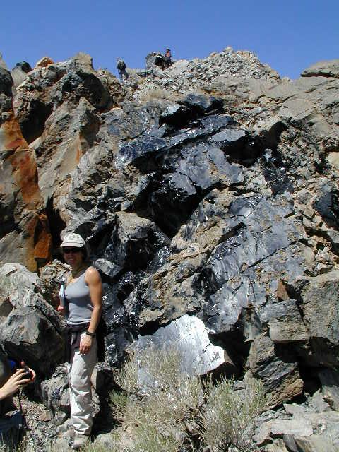
 First is the most magnificent fault face I have ever seen.
It is about a mile below Virginia City.
Left is the view looking down the fault, right is looking up it.
First is the most magnificent fault face I have ever seen.
It is about a mile below Virginia City.
Left is the view looking down the fault, right is looking up it.
Notice how slick the fault is. It looks wet. It is smooth like dinnerware, surprisingly unweathered. Tough stuff, whatever this material is, because it has probably been exposed to weathering for a long time. The picture of the hammer (below) shows the grooves along the direction of fault slippage. Grooves are parallel lines in the rock especially visible upslope from the hammer head. These grooves are called slickensides.
How to find this spot
 This spot is about a 15 minute upslope scramble from the road.
There are two roads going upslope to Virginia City from route 395.
One leads thru Silver City.
You want the other, the truck route.
You need to stop about a mile short of the town.
Notice my camper in the highway pullout above.
There is room for a half dozen or so cars there.
Hike up the canyon from the pullout and then work your
way over onto the left side ridge.
Up the road is the old gold and silver mining town, Virginia City,
which is now well prepared for tourists.
No need to disappoint them.
This spot is about a 15 minute upslope scramble from the road.
There are two roads going upslope to Virginia City from route 395.
One leads thru Silver City.
You want the other, the truck route.
You need to stop about a mile short of the town.
Notice my camper in the highway pullout above.
There is room for a half dozen or so cars there.
Hike up the canyon from the pullout and then work your
way over onto the left side ridge.
Up the road is the old gold and silver mining town, Virginia City,
which is now well prepared for tourists.
No need to disappoint them.
If you should happen to be awake at dawn in Gardnerville (or Minden), Nevada, be sure to check the city park to see if anyone is taking off in a hot-air balloon. I happened to have the pleasure of cheering a launch party with the Lake Tahoe Hot Air Balloon Company.
Traveling south on 395 along the Walker River (sorry no picture) we saw a roadside campground and tree stumps in the creek. When you think about it, this is pretty amazing. You almost never see trees in a river or lake. Too much water kills them. Here the stumps were in the rapid flowing, maybe knee-deep, water. This river/creek is locked into its rocky banks, so the creek didn't recently meander onto the tree locations. This tells us without doubt that the climate was drier in the past. Dry enough that trees could grow in the middle of what is now a creek. Think about that. The trees have about 150 growth rings. Some geologist thought about it and decided to send samples to a lab for carbon dating. These trees were born about the year 1100AD and died about 150-200 years later. So, they had a mighty long drought back then. This isn't the only example. In dry seasons, many California and Nevada lakes expose tree stumps that indicate many long droughts as a part of our past. Obviously, we can expect more of them in the future. Indeed, experts say we are now at an unusual time -- plenty of water.
 North of the town of Lee Vining is a turnoff east to the town cemetery.
Less than a mile past it, you'll pass this amazing outcrop.
This picture shows about a third of the total exposure, the other exposures
being more strung out and fragmentary.
Next time I come here I'll bring a garden hoe to uncover more of it.
Some people oo'ed and aah'ed at the aesthetics.
I oo'ed and aah'ed at the challenge this would present
to a reflection seismologist.
Everyone wondered how it was formed
and several people came up with explanations.
Someone suggested that in an earthquake (or something)
the upper horizontal layer moved to the right
(while the lower horizontal layer was fixed.
This then would cause a great deal of shear on the swirly layer of interest.
I came up with this idea:
Imagine a fairly soft layer between two stiffer ones.
The soft layer might be soft because it is carrying spring water.
Suddenly a volcanic eruption (many nearby) piles a big load
of rock on the left side. The soft stuff, like toothpaste,
squirts towards the right side.
Simon thought it formed underwater as a result of a landslide.
Amos Nur says
the folded soft beds are called Seismites - quite common in soft lake
beds due to earthquakes. They occur when the layers are at the lake
bottom or buried only by a few cm or decimeters of soft sediments.
North of the town of Lee Vining is a turnoff east to the town cemetery.
Less than a mile past it, you'll pass this amazing outcrop.
This picture shows about a third of the total exposure, the other exposures
being more strung out and fragmentary.
Next time I come here I'll bring a garden hoe to uncover more of it.
Some people oo'ed and aah'ed at the aesthetics.
I oo'ed and aah'ed at the challenge this would present
to a reflection seismologist.
Everyone wondered how it was formed
and several people came up with explanations.
Someone suggested that in an earthquake (or something)
the upper horizontal layer moved to the right
(while the lower horizontal layer was fixed.
This then would cause a great deal of shear on the swirly layer of interest.
I came up with this idea:
Imagine a fairly soft layer between two stiffer ones.
The soft layer might be soft because it is carrying spring water.
Suddenly a volcanic eruption (many nearby) piles a big load
of rock on the left side. The soft stuff, like toothpaste,
squirts towards the right side.
Simon thought it formed underwater as a result of a landslide.
Amos Nur says
the folded soft beds are called Seismites - quite common in soft lake
beds due to earthquakes. They occur when the layers are at the lake
bottom or buried only by a few cm or decimeters of soft sediments.

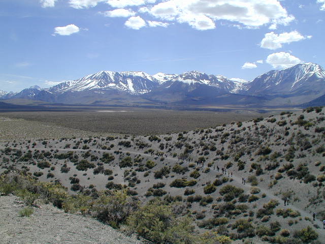
Continuing east beyond this outcrop you pass north of a big mound on the northern shore of the lake. Turn right to head south towards it. There is a fork in the road. You could go left towards the lake shore and hike up from there. Instead we went right and drove half way up from the back (north) side. Not having 4x4 vehicles we were stopped by some huge dirt moguls so we hike about a mile from the moguls to the end of the road. From there it is another quarter mile to our destination.
Reaching the ridge (or dome like shape) we find
it has many cracks that eroded into some nifty looking mini-canyons,
 some as deep as 30'-50' and too wide to jump across.
Since this is nearly at the height of land one must wonder where
all the water comes from that makes this dramatic canyon erosion on
this fairly recent volcanic high.
I was thinking that a topographic high might attract
summer thunderstorms with their flash floods.
Simon says that tufa deposits on the walls of some of the minicanyons
show at least in part they formed below lake level.
When we think about the history of these rocks we must keep in mind
the always fluctuating lake levels, especially the
dramatic one a mere 13,000 years ago at the ending of the ice age
when the lake water was a thousand feet deeper.
some as deep as 30'-50' and too wide to jump across.
Since this is nearly at the height of land one must wonder where
all the water comes from that makes this dramatic canyon erosion on
this fairly recent volcanic high.
I was thinking that a topographic high might attract
summer thunderstorms with their flash floods.
Simon says that tufa deposits on the walls of some of the minicanyons
show at least in part they formed below lake level.
When we think about the history of these rocks we must keep in mind
the always fluctuating lake levels, especially the
dramatic one a mere 13,000 years ago at the ending of the ice age
when the lake water was a thousand feet deeper.
Mono Lake
Mono Lake is about 3 times saltier than sea water. Proceeding south we pass a motel on the right and ask the proprietor for permission to walk down a private road to the waterfront. The water was absolutely clear. We could see brine shrimp about a centimeter long. The water has a "slippery" feel to it. Mark Twain claimed Mono Lake water is excellent for laundry. We didn't have time for swimming. Swimming is said to be best on the south shore at Navy Beach.
We met Prof Joe Kirschvink from Cal Tech at the waterfront. He and his students were collecting magneto-tactic (magnetic field sensing) bacteria in the mud beneath the lake. They were doing DNA analysis to sort out the evolutionary history of the various bacterial species and the emergence of the genes for sensing magnetism.
 We return to the main highway and head south a short way
where we find a nice public park with a boardwalk access
to the lake shore.
There were lots of birds.
Just off shore there are fresh water springs beneath the salt water lake.
For some reason, many birds congregate above the springs.
Maybe a good spot to feed.
This is best seen with binoculars from the end of the boardwalk.
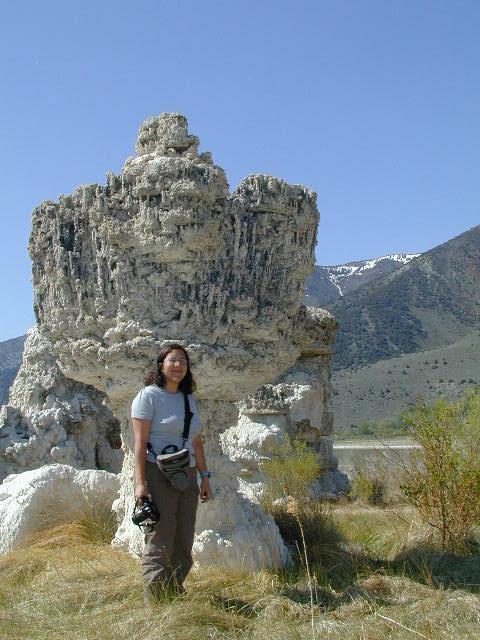
Geologically, when hot waters in the earth rise to the surface
they cool, often depositing their dissolved mineral load.
(The great silver mines of the west fit that model.)
When these hot water springs emerge below the lake,
the minerals tend to precipitate right there at the
mouth of the spring.
We return to the main highway and head south a short way
where we find a nice public park with a boardwalk access
to the lake shore.
There were lots of birds.
Just off shore there are fresh water springs beneath the salt water lake.
For some reason, many birds congregate above the springs.
Maybe a good spot to feed.
This is best seen with binoculars from the end of the boardwalk.
Geologically, when hot waters in the earth rise to the surface
they cool, often depositing their dissolved mineral load.
(The great silver mines of the west fit that model.)
When these hot water springs emerge below the lake,
the minerals tend to precipitate right there at the
mouth of the spring.
When the water level drops you get to see the chimney as we do in this picture. When the water level drops, the waves chew away at the chimney leaving this picture, a big chimney on top of a smaller chimney.
We were always on the lookout for ancient shorelines. We can see old shorelines above the present one. Obviously we can't see the ancient shorelines now submerged. Remember what we learned from the tree stumps. Long droughts are common so the present high water hides from us a lot of shoreline history.
 In the last 50 years
the water level dropped about 10 meters (I recall)
since Los Angeles began drawing water from the sources of Mono Lake.
The courts mandated that the water level be restored,
and that has begun.
We'll see whether the courts can mandate a stability
that nature does not have [heh, heh].
In the last 50 years
the water level dropped about 10 meters (I recall)
since Los Angeles began drawing water from the sources of Mono Lake.
The courts mandated that the water level be restored,
and that has begun.
We'll see whether the courts can mandate a stability
that nature does not have [heh, heh].
Now we go to the south side of the lake. Here are some big blocks of pumice. Pumice is rock with lots of bubbles in it. Lots of volcanism here. We threw some chunks into a creek and they floated away downstream.
 A mile or two south of the lake is Panum Crater (good signage to parking lot).
(I have some narcissistic old personal memories here.)
One trail takes the canyon rim. Don't take that trail.
The other trail works its way up a central pinnacle
containing some nice shiny black obsidian
behind Darcy's back and higher.
(The color pictures on the web site distinguish
better than paper the black rocks from the shadows).
The dense obsidian is made of the same stuff as the pumice
that floated on water. The difference is that the gas
that was trapped in the pumice (giving it all its internal bubbles)
somehow escaped from the obsidian (or was never present).
The rapid decompression of gas is what gives pumice its bubbles and buoyancy.
A mile or two south of the lake is Panum Crater (good signage to parking lot).
(I have some narcissistic old personal memories here.)
One trail takes the canyon rim. Don't take that trail.
The other trail works its way up a central pinnacle
containing some nice shiny black obsidian
behind Darcy's back and higher.
(The color pictures on the web site distinguish
better than paper the black rocks from the shadows).
The dense obsidian is made of the same stuff as the pumice
that floated on water. The difference is that the gas
that was trapped in the pumice (giving it all its internal bubbles)
somehow escaped from the obsidian (or was never present).
The rapid decompression of gas is what gives pumice its bubbles and buoyancy.
Devil's Postpile
Next we go south to Mammoth Lakes area. Every time I found myself here for the last 35 years I found the Devil's Postpile road is still snowed in. This year was no different. We consoled ourselves by driving up towards Horseshoe Lake which is surrounded by trees that have died from the carbon dioxide seeps associated with current volcanic stirrings.
Lateral moraines
 When glaciers flow out of the mountains, they push
rock rubble in front of them.
When a glacier emerges out onto the plains,
it will also push a lot of rock rubble up on either side.
The side rock rubble often makes a sharp ridge on either
side of the glacier descending gently to the lower valley floor.
This picture shows only the nearer of the two descending ridges
(called lateral moraines).
The ridge is descending but coming towards us which is why it looks higher
on the right side of the picture.
When glaciers flow out of the mountains, they push
rock rubble in front of them.
When a glacier emerges out onto the plains,
it will also push a lot of rock rubble up on either side.
The side rock rubble often makes a sharp ridge on either
side of the glacier descending gently to the lower valley floor.
This picture shows only the nearer of the two descending ridges
(called lateral moraines).
The ridge is descending but coming towards us which is why it looks higher
on the right side of the picture.
To confuse matters here, there is a fault running just in front of the mountains. This fault moves from time to time which chews up the ridge top (the dip just in front of the mountains).
 Here is a winter airplane view of the same location.
Now you can see both lateral moraines and you can see
that the fault in front of the mountain has chewed up them both.
Here is a winter airplane view of the same location.
Now you can see both lateral moraines and you can see
that the fault in front of the mountain has chewed up them both.
One of the most delightful hikes I ever made was a late spring walk up along the spine of a lateral moraine like these in the morning (with the sun behind me shining on the snowy Sierras in front of me). Lunch under the mountain trees. For the afternoon descent, the walk back down the spine of the lateral moraine was like a glider flight landing -- my whole field of view open and downward. The afternoon walking scenery viewing eastward is even better lit by the setting sun -- the Nevada White Mountains, almost as high and snowy as the Sierras but much more desolate.
Everybody is looking for faults all the time. Mostly whenever you see a straight line on the landscape, it's a fault, unless it is horizontal, in which case it might be an ancient shoreline.
Lookout Mountain
The Mammoth Lakes ski area is quite high. East of it lies Lookout Mountain which at 8300' is even higher. A gravel/dirt road leads to the top. It was not a difficult drive. At the top is a 360 degree view from which we could easily convince ourselves that we could see much of the rim of Long Valley Crater (not all of it), a crater about 10 miles in diameter(!) which blew out 760,000 years ago sending a measureable thickness of volcanic ash as far away as Yellowstone Park. Traces of volcanic ash from this explosion went 3/4 of the way around the world to the western Pacific. It felt wonderful on top of Lookout Mountain. I think I'll return some night for star gazing.
I'd like to return to Lookout Mountain, but I have never seen a place where all the maps (both the highway maps and topo maps) were so unlike the ground truth. Here is my idea of ground truth: Start heading north and then east on the Mammoth Scenic Loop. Cross highway 395 and continue on a dirt track for about a quarter mile. You come to a crossing with a better quality gravel track. Turn right. After a mile or two you come to a fork in the road. Stop and look. You might see the primitive sign for "Lookout" (or the back side of it) which indicates you want the left fork. Take it and just keep on going.
Hot Creek Geological Site
Be sure to bring your swimming suit! Those little dots below on the path and in the water are people. Driving south on 395 we get to the north end of the Mammoth Lakes airport. Turn east and go about three miles. The Hot Creek Geological Site provides public swimming in Hot Creek. This means there are also toilets and changing areas. The water in the creek isn't awfully well mixed so you'll find spots that are too hot and others that are too cold. If you go to where the people are, you'll probably find it almost about right. It seems that the creek is heated from steam entering from below so you can almost feel the rumble as the steam bubbles collapse on encountering the cooler creek water. You might almost feel like you are in a cooking pot.

Now let us suppose you are tired of swimming with other people and you'd like your own private natural hot tub in the wilderness. You could try this: Go south to Benton Crossing Road. Take it east past Whitmore Hotsprings. Two miles further is a crossroads. Someone said there was a hotspring to the right. We went straight a ways further and suddenly the road dropped down onto an alkaline flat. Take an immediate left over a hardpack leading to a parking lot within a mile. From there on you walk a board path, hop over puddles, etc until you come to it. A hole in the earth (actually not earth but the alkaline flat) with seats for four. Someone has thoughtfully arranged a valve on a four inch PVC pipe which you can use to adjust to suit the temperature you like. Since we were more than four people, we didn't stay to try it.
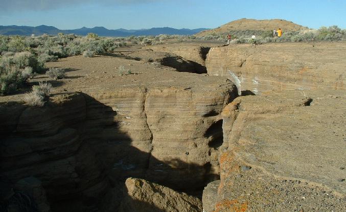
Owens River gorge
The Owens River gorge is about 1000' deep and 600' across. Spectacular! And the rhyolite (volcanic rock) columns in its wall, fantastic! A beginner should never start here. A beginner should start looking at cracks in a pool of dried mud. Have you ever seen the geometrical pattern of the mud cakes? You might see hexagons about 7-10 inches in diameter. They are not completely regular hexagons, but they are remarkably regular. Next you should look at Devil's Postpile but since it is snowed in, I'll explain you the theory of Devil's Postpile and the many other sites like it (for example northeast Yellowstone). Start with a big lake of lava. The top of it cools, contracting while it cools. So the top of the lava lake starts to look like the dried up mud pond with hexagonal cracks. As the cooling progresses, the hexagonal cracks work their way downward and voila! -- you have hexagonal columns. Got that figured out? If not, skip the next two paragraphs.
I'm a beginner. My vision is this: Here 760,000 years ago was was the Owens River flowing along at the bottom of its canyon which was then maybe half as deep as it is now. Now it is about 1000' deep and 600' across. Maybe then the gorge was 500' deep. So, one day a giant fissure appears in Long Valley (remember Lookout Mountain?) which explodes upward. Imagine a column of rock shot miles up in the sky. Rock raining down from a mile or more achieves supersonic velocity (according to mv^2 =2mgh, v=300, g=32). (There is little air drag because falling rock drags the air down at almost the same speed). This downdraft of rock and air impacts the earth exploding outward over the landscape in a turbulent fury of scorching boulders demolishing everything in its path. Plenty of the scouring debris lands in the Owens River gorge. Then fiery hot lava pours out of the fissure and covers the landscape to the depth of maybe 400'. Hell on earth! Naturally the gorge fills with lava on top the debris but the lava is pretty viscous so it does not penetrate to the bottom thus leaving cracks for water to percolate along the river's original channel. In following years the rain still fell and the the Owens River still trickled along its original course though now beneath 400' of molten lava.
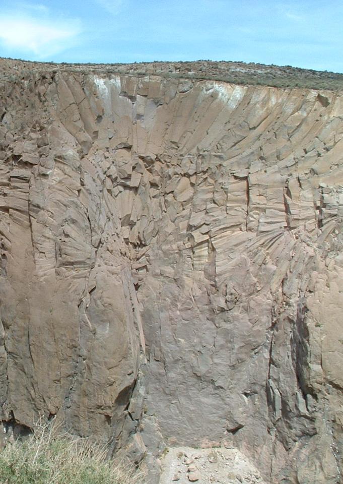 So, now we have this big lava lake cooling on the top plane because of
the atmosphere, and cooling along a subterranean line which was
the original Owens River.
Hexagonal cracks form from the earth surface,
but they also nucleate from
the now subterranean Owens River because it is also cooling the lava.
The cracks evolve towards each other,
and what we get is the magnificent rosette you see in the picture.
Since little on this picture gives you a sense of scale
I'll guess that your field of view here is about 500' wide.
Click to see further down the far wall of the gorge.
You might be able to pick out some rock climbers on the other side
(or maybe not).
So, now we have this big lava lake cooling on the top plane because of
the atmosphere, and cooling along a subterranean line which was
the original Owens River.
Hexagonal cracks form from the earth surface,
but they also nucleate from
the now subterranean Owens River because it is also cooling the lava.
The cracks evolve towards each other,
and what we get is the magnificent rosette you see in the picture.
Since little on this picture gives you a sense of scale
I'll guess that your field of view here is about 500' wide.
Click to see further down the far wall of the gorge.
You might be able to pick out some rock climbers on the other side
(or maybe not).
Now let's get past my beginner's view and hear the conventional wisdom. There was no river gorge here before the eruption. The Bishop tuff (volcanic rock) erupts 760ka bp and deposits scorching ash to great depth here. The ash is so hot it melts itself together into solid rock. Springs percolate up from below (vertical cooling lines this time instead of horizontal ones as I imagined). Where water appears at the surface it deposits its dissolved minerals as "tufa mounds" (maybe visible on the photo). A lake forms back up north in the Long Valley caldera. Some time later the lake cuts thru the south wall of the caldera and erodes the Owens gorge exposing the rosettes. Next time I go there I'll need to examine the rosettes with great care to try to see whether they originate from vertical or horizontal lines.
The Owens River gorge is at a much lower altitude than our previous locations.
I recommend an early morning visit (with some cool)
or a late afternoon visit (with some shade).
Start about 10 miles north of Bishop on 395.
Turn east on Gorge Road (small street sign)(or turnoff to gorge power plant).
After about a half mile the road dead ends at a spectacular pipeline
-- water to Los Angeles.
Turn north. At exactly 6 miles, the road forks.
 Take the right fork. You will soon start dropping into the gorge.
There will be a locked gate and many parked cars.
The cars belong to rock climbers and fisherman.
Park and follow them down the road past the gate.
Take the right fork. You will soon start dropping into the gorge.
There will be a locked gate and many parked cars.
The cars belong to rock climbers and fisherman.
Park and follow them down the road past the gate.
We were thrilled with our campsite midjourney among the trees by the creek. No strangers there. Creekside tent sites for each of us. It was Memorial Day weekend. Nobody was here because it isn't marked. And it isn't marked because there are no toilets so it isn't suitable for intensive use. To keep it nice and clean we agreed not to tell anyone where it is, except that we might return here ourselves with our families. You are family, right? You have a latrine shovel, right? Then ask me directions. Enjoy!
If you are viewing this page with Microsoft's Internet Explorer you might not have noticed that many of the pictures here will enlarge if you click on them.