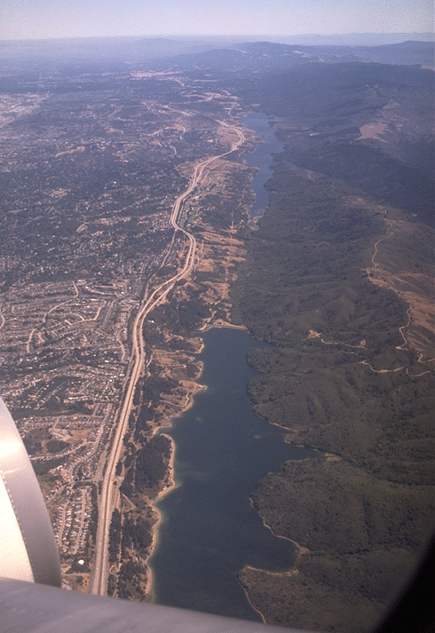
This image shows San Andreas Lake and Crystal Springs reservoir from the air, looking SouthEast from HERE. The highway paralleling the lakes to the left is Interstate 280, ``the most beautiful urban highway in the United States''. (And it is indeed very scenic.)
This valley is remarkably straight because the San Andreas fault runs down its center. The San Andreas is a classic ``Strike Slip'' fault: the two sides (for the most part) move past each other horizontally. (San Francisco Bay is there at least partly because the block between the San Andreas on the West and the Hayward fault on the East has been downdropped a bit, but that motion is small compared to the tremendous horizontal displacements that have occurred along these faults.) The vegetation and terrain on either side of the lakes look different partly because the underlying rock IS geologically very different. The rock on the right came from the Southern Sierra Nevada mountains, and has been transported from several hundred miles to the South by motion along the fault. With each San Andreas earthquake, it continues a few more feet (or tens of feet) on its long slow journey North (eventually to be plastered onto Alaska?).
San Andreas Lake (from which the fault takes its name) is a ``sag pond'' that naturally formed in the valley of the San Andreas fault. Strike slip faults are good places for lakes; the fault both creates a low spot to collect the water, and grinds up the rock underneath making an impermeable layer to hold the water in. Man has enlarged San Andreas lake with a dam, and created two additional lakes in the same valley, Upper and Lower Crystal Springs Reservoirs. The dam holding the reservoirs in place is under a bridge on highway 280 (but you might be distracted as you drive over it by the sight of the gleaming white ``dome home'', a spray-foam wonder visible from the same bridge on the other side).
These lakes hold the water supply for the City of San Francisco. The water first comes via aqueduct from Hetch-Hetchy reservoir in the Sierra Nevada mountains (next to Yosemite, more than a hundred miles away to the East), then in a tunnel under the Southern part of San Francisco bay, in a tunnel up the San Francisco peninsula (passing along the base of the hills just West of Stanford University), and finally enters the reservoirs at the ``Water Temple''. The Water Temple is a local tourist attraction and favorite bicyclists' rest stop that you can visit by car (or on some weekends only by bike) on the West side of Canada (pronounced Canyada) road.
Now look at the photo again, and extend the line of the lakes to the horizon. Instead of a valley we find 3000-foot tall Black Mountain (located about HERE, just West of Palo Alto and Stanford University) astride the fault. The fault changes orientation at Black Mountain by about 9 degrees, and the land on either side is being crumpled and uplifted as it gets dragged around the corner. (Scholz, 1985)
In the great earthquake of April 1906 (which began about HERE and propagated out both North and South) the displacement was up to 21 feet in the Point Reyes area, the largest surface displacement ever recorded. Along the San Francisco Peninsula section of the fault (the part visible in the first photo) the displacement was less, and it dropped yet again South of Black Mountain. Some geophysicists speculate that this might have happened because the moving rupture partially dissipated when it hit the obstruction.
On the theory that the great 1906 earthquake did not dissipate much of the accumulated strain South of Black Mountain (as it presumably did North of San Francisco), the USGS in 1988 assigned a relatively high risk (30% over the next 30 years) of a major earthquake along the Santa Cruz Mountains section of the San Andreas, between Black Mountain and San Juan Bautista (located HERE). This was the highest risk assigned to any fault segment in the Bay Area. (Ward and Page, 1989)
What about even farther South? The risk on the part of the fault South of San Juan Bautista (all the way down to just North of Parkfield) is considered low. Along that section the San Andreas seems to continually creep, constantly releasing strain and thus not storing enough energy for a major earthquake.

If you drive up Page Mill Road from Palo Alto, the main trace of the San Andreas fault is noticeable as an abrupt dip in the road just before you start up ``three grunt hill'', a short steep stretch of road (infamous among bicyclists) just downhill from Monte Bello Open Space Preserve on the left (West) and Los Trancos Open Space Preserve on the right (East). At the entrace to both of these preserves there are free trail guides that point out features associated with the fault: sag ponds, push-up ridges, long straight valleys, fences offset in 1906, etc. In particular, just inside Monte Bello Open Space Preserve note the long skinny cattail pond next to the trail up Black Mountain. That's another sag pond trapped by the San Andreas fault, a miniature version of San Andreas Lake. (It's quite astonishing during summer in this otherwise bone-dry area to come upon a little pond complete with frogs and cattails!)
The above image shows a view to the SouthEast from ``Vista Point'' (a mile or so South of the top of Black Mountain), a rest stop on the Stevens Creek nature trail. The panorama takes in the headwaters valley of Stevens Creek. This valley again marks the San Andreas fault, here taking off to the South at its new orientation, heading for San Juan Bautista, Almaden Cienega Winery, Melendy Ranch, Pinnacles, Parkfield, and (eventually, after some rather more dramatic twists and turns around the Los Angeles basin) the Gulf of California.
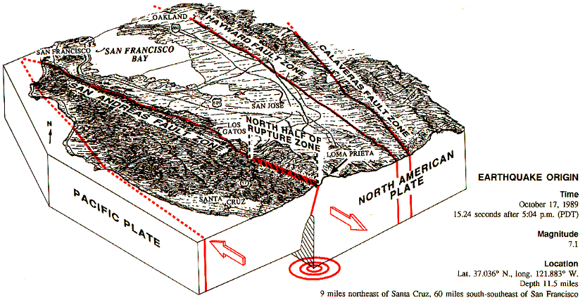
The highest mountain visible in the distance is Mt. Umunhum. On a clear day an even higher mountain, Loma Prieta, would be visible slightly above and to the right of Umunhum. Loma Prieta (located HERE) became famous as the spot near where the October 17, 1989 "World Series" earthquake rupture began. (Large earthquakes are named after places near their epicenters, with larger earthquakes being given the names of more important places.) Gratifyingly (at least for USGS geophysicists) this happened right in the middle of the stretch of the San Andreas fault previously identified as ``high risk'', on the basis that there had been a persistent ``gap'' in the earthquake activity there. The Loma Prieta earthquake rupture spread both North and South from the epicenter, filling most of the previously noted gap, but stopped well short of reaching Black Mountain.
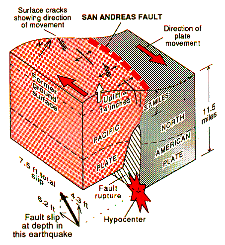
This leads to the obvious question... is enough strain to power another significant Bay Area earthquake yet stored along the stretch of the San Andreas around Black Mountain? And was the Loma Prieta earthquake really the one that the USGS had expected? (There is some disagreement about that, because the aftershocks map out a fault plane dipping at about 70 degrees to the SouthWest, not a vertical one as had been expected for the San Andreas, and the movement was a combination of about 2/3 strike slip and 1/3 thrust faulting, not purely strike slip.)
What about the peninsula section of the San Andreas fault? It also moved less than areas farther North in 1906, and the USGS in their 1988 report gave it a probability of 20% of producing a major earthquake over the next 30 years. Will it also produce a major earthquake sometime soon? Is there another ``seismic gap'' between Portola Valley and San Francisco? Here is the USGS's current best guess at the risks.
Something to ponder when you go to Monte Bello Open Space Preserve to enjoy nature some weekend...
In the meantime, you can check up on current earthquake activity in the San Francisco Bay Area courtesy of the USGS.
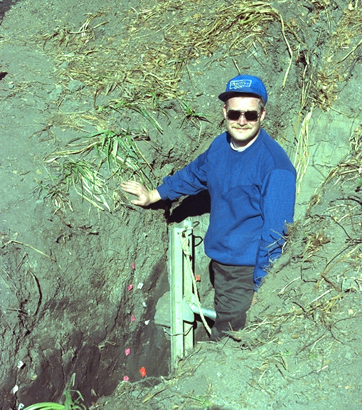
Here I am standing in a trench dug perpendicularly across the San Andreas fault in a swampy (well, it can be swampy during Winter) lowlying part of the fault valley. This trench is located at the ``Vedanta retreat'' in the town of Olema, about HERE, in the middle of the Point Reyes peninsula very near the epicenter of the great 1906 earthquake. Tina Niemi, a Stanford graduate student at the time, dug this trench (one of several) as part of her thesis work, spending two summers studying it.
The goal was to try to date previous large earthquakes on this stretch of the San Andreas fault. (If we can discover when large earthquakes have occurred in the past, it lets us start to make educated guesses about when they might occur in the future.) The idea is that an earthquake that ruptured to the surface would disrupt the soil under the swamp, causing a noticeable discontinuity in the soil horizons. This is not an unreasonable assumption: we know for a fact that the fault moved horizontally 21 feet (six and a half meters) here in 1906! Any surface disturbance would become buried as the swamp continued to fill in; later earthquakes would thus leave discontinuities closer and closer to the present-day ground surface.
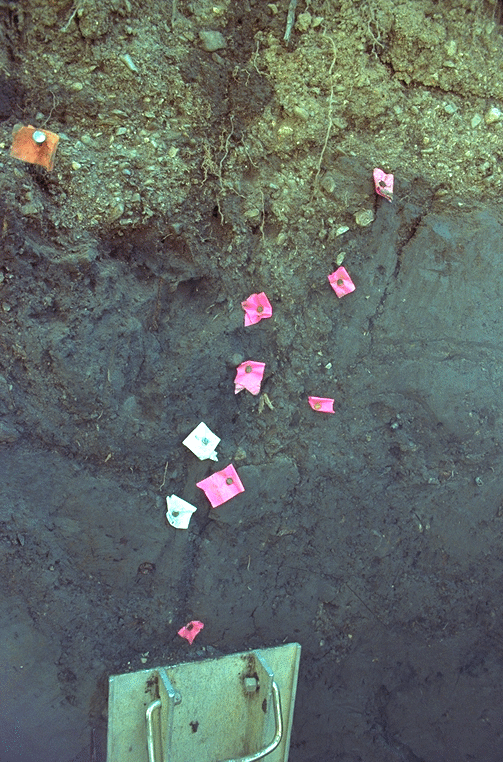
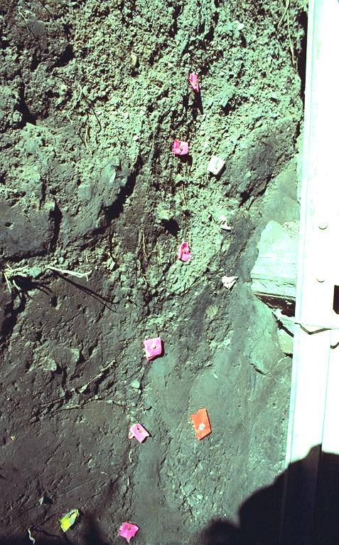
Here are close-up views of the trench wall. These show only the very top; the trench was about 10 feet deep. Notice how (lighter colored) material spilled down into the gap left by an earthquake rupture, and then that former ground surface was itself buried.
Graduate students laboriously mapped out and marked each discontinuity they could find with brightly colored flags. (If one feature crosscuts another, that's good evidence the displaced feature was there first and so older.) Bits of organic matter buried by a disruption can be dated, putting bounds on the date of the corresponding earthquake. The most recent earthquake should be marked by the discontinuity that comes closest to the present surface. (My hand is resting on that one.) This provides a consistency check, because the time of THAT earthquake is precisely known: April 1906.
The students also dug trenches parallel to the fault, on either side. The idea behind this was to find correlatable subsurface features offset by motion during prehistoric earthquakes. If enough corresponding features could be found and dated, it becomes possible to calculate not only when prehistoric earthquakes occurred but also how much the fault offset during them.
The students were lucky enough to find something quite remarkable in those trenches: a Redwood tree that had died, fallen perpendicularly across the fault, and become buried. It was then spectacularly splintered and ripped in two by a later earthquake, providing a rather dramatic record of fault displacement!
Thanks to Ramon Arrowsmith for pointing out to me the reference on the Black Mountain asperity. Thanks to the USGS for the Loma Prieta illustrations. Thanks to Jon Claerbout for letting me put this ``Virtual Field Trip'' on SEP's web site.