Mount Ritter/Ediza Lake
| Summary
| Image Gallery
| Trip Map
- Date: August 24-26, 2001
- Route: Camped at Lake Ediza, via Agnew Meadows trailhead. Climbed Mount Ritter as a daytrip.
- Total distance: 20 miles.
|

Click Here
| 
Click Here
| |
Ritter is a real mountain. Rugged, steep, and remote. A large glacier turns the standard route from a
straightforward scramble into a real alpine climb. We planned to take a three-day vacation to the area,
where we'd camp at Lake Ediza and climb Mount Ritter on day two. We got a late start from the Bay area
on Thursday night at 10 pm or so, but secretly, I think we wanted this in order to better test the
convenience of our new, hand-built camper for late-night camping. We pulled into a surprisingly full
Hogsdon Meadow campground around 1 am and were in bed within ten minutes.
After a mere 4 hours of sleep, we hit the road and headed for Mammoth, to pick up a permit. It was here
that we hit our first piece of red tape. From 8 am to 5:30 pm every day, passenger cars are not allowed
over Minaret Summit. Instead, we tax-paying citizens must pay $9 apiece to ride a shuttle bus (operated by
Mammoth ski area). Of course,
the permit office doesn't open until 8 am. Initially, I was tempted to include a third degree rant in this
otherwise lame and tame trip report, but after reading some of the literature that came with our permit, I
learned that the USFS has noticed the same injustice and plans to make the Reds Meadow/Devils Postpile area
a National Forest fee area. Presumably, since the fees will now go to the USFS, we taxpayers will see some
return on our investment, like reduced shuttle bus fees and improved infrastructure.
We also found the camping regulations (location, food storage, etc.) to be more restrictive than in
Yosemite. Odd, until you realize that the Pacific Crest and John Muir Trails meet at Agnew Meadows.
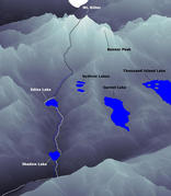
After our mandatory bus ride, we started from that trailhead at 11 am. The amount of foot traffic on
the trail was unsurpassed relative to anything I'd seen in Yosemite, and this was a friday! The trail
descends gently over the first couple miles to a footbridge over the San Joaquin River. From there,
you climb about 700' to Shadow Lake. The abruptness and quality of the change in vistas amazed me. One
minute, we were slogging up the switchbacks of a steep, blazing trail; the next minute we were along
the shore of crystal clear Shadow Lake, with
stunning views of Mount Ritter and Banner Peak.
After another 3-4 miles of slogging along the dusty (thanks to the legions of crapping livestock), forested trail,
we reached Lake Ediza. If we hadn't have been so tired (we had ice axes, crampons, helmets, 3 days' worth of food,
flyfishing gear, tent, sleeping bags), we'd probably have enjoyed the gorgeous scenery more. In any case, we
set up our camp (How about these views
[ 1 |
2 |
3 ]?)
and even mustered the energy to do some
flyfishing,
though to no avail. But sleep was our foremost prerogative, for tomorrow, we planned to conquer mighty Ritter, which loomed 3900
feet above our camp.
I wanted to get a really early start, thinking that there might still be snow on Ritter's southeast glacier.
If we started early enough, we could climb on firm snow and glissade on softer stuff.
In reality, the glacier is permanently (until next year's snow) hard and icy.
Anyhow, we left camp around
7:15 am, and followed a use trail along the unnamed stream toward the Ritter/Banner saddle. Around 3100 meters (I will use meters
for the remainder, since the USGS 7.5-minute "Mount Ritter" and "Mammoth Mountain" topos use meters, with a woeful 20-meter (66-foot)
contour interval.) you reach a flat bench and the use trail peters out. From there, you can barely see the easternmost (and lowest)
of Ritter's three glaciers.
Trend diagonally uphill and climb a fairly obvious, very rotten class 2(3?) gully. At the top of the gully, veer a bit south, to avoid a series
of very smooth, very class 5 cliffs which seem to fit between the contours of the map. After you pass the cliffs, skirt the north
side of the "east glacier". Eventually, you will have Ritter's southeast (main) glacier to your left, a band of rocks leading uphill
to the center, and Ritter's "north" glacier to your right (Confused? This
annotated photo should help!).
We elected to directly climb the southeast glacier, up some fairly steep (35-40 degrees?) snow. If you choose to climb
the rock band, you will find definite class 3 rock. If not wet, this smooth, polished rock will likely be coated with a fine
layer of dust, making for some slippage. The north glacier may be the easiest route, as it is much less steep for the most
part.
The steepness of the glacier relented near the top, and the hard bluish ice gave way to deep snow runnels. At 3700 meters,
we exited the glacier and began climbing the south face of Ritter. At the top of the glacier, you may be lured by a very
prominent gully on the left which I hear is quite difficult. I hear that it is easier (we did this) to climb the loose
south face directly. With enough route finding, the climbing is all class 2. At 3800 meters, the terrain flattens, and we
made our way to Ritter's south ridge. Between 3850 meters and the summit (4006 meters), we climbed more loose gunk, which
again stays class 2 if you search, although there are fun boulder problems here and there.
I reached the summit around 11:45, while Kim joined me 10-15 minutes later. We thumbed through the register and enjoyed
a few of the entries. Especially,
	Bagged Ritter in 1.5 hours from Shadow Lake.
	With my wife Morgan Fairchild.
	That's the ticket!

	-Joe Blow (age 87)
I found another package hidden under more rocks and wrapped in plastic. Not knowing what was inside, I opened it, only to
find a package left by a guy in 1997 for his then-newborn son. When I realized what it was, I felt guilty and
wrapped it back up. If "dad" happens to read this trip report, your plastic bag has been gnawed by rodents! I wrapped it as
best as I could and tried to put it in a good shelter for the coming winter.
On our hour of blissful weather and great views from the summit, we recognized many peaks, marveled at the fantastic lakes
thousands of feet below us, and cursed at the forest fire smoke that heavily obscured views to the south and southwest.
As we left, we felt the wind shift, and watched the blanket of smoke drift inexorably toward us. Before we were down, our
camp would be enveloped with the acrid stuff.
In any case, as they say, reaching the summit only means you're halfway done with the climb. We inexperienced ice/snow
climbers still had a glacier to descend, as well as 2000 feet of loose class 2 boulders. I tried plunge stepping on the
hard snow near the top of the glacier, but a quick spill taught me the errors of my ways. Luckily I came to rest in a deep
snow runnel before I got far. We gingerly descended the steeper parts and elected to downclimb the central rock band
instead of directly descend the southeast glacier, which we had ascended. We're still debating whether we should have
gotten more aggressive with our plunge steps. In any case, caution was the best alternative, since a fall would have
been difficult to arrest, and likely would have ended up in the rocks at the bottom.
We took our time on the downclimb and made it back to camp around 5 pm. Much slower than I had anticipated. Probably a
general symptom of my underestimation of this mountain. This is a big, challenging sucker! But worth the effort. I
feel like we learned quite a bit and even managed to enjoy ourselves.
© 2005
, Stanford Exploration Project
Modified: 11/18/05, 13:53:04 PST
, by morgan
Page Maintainer: morgan `AT' sep.stanford.edu


