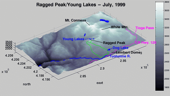
Ragged Peak
| Summary
| Image Gallery
| Trip Map
- Date: July, 1999.
- Route: Ragged Peak area via Young Lakes trail.
- Total distance: ~12 miles.
|
Click Here
| 
| |
There's always one week in early summer...
...when it's really hot in Northern California.
We took this trip the weekend after July 4, 1999. Must've
been 110 in Groveland on our way down. Kim and I joined
Steve Farrell and Howard Hicks for an overnighter in the
Ragged Peak/Young Lakes area.
The approach is quaint and popular among dayhikers. The
trail first passes Dog Lake after a tough 700 foot ascent,
then marches over two gentle ridges. The large, open valley
of Delaney Creek is quite impressive. We immediately found
that the mosquitoes were abundant and agressive.
Deciding that the mosquitoes were too much, we made camp below
the west ridge of Ragged Peak (10,900+) and elected to do some
scrambling around Ragged Peak instead of making a trip to Young
Lakes.
All four of us scrambled up the south face of Ragged Peak,
eventually reaching a point around 10,300' elevation. From there,
Kim and I hiked to a narrow saddle east of Ragged Peak for some
views to the ampitheatre which contains Young Lakes. The views
were stunning, and capped off by the monolithic west face of
Mount Conness.
The temperture was surprisingly warm that night, and the mosquitoes
didn't abate until well after dark. Warm tempertures in the
early summer at high elevations make for alarmingly abundant
mosquitoes.
Kim scrambled up Ragged Peak next morning while I slept, and we
were on our way by 9 am; again fighting the mosquitoes. I suppose
the mosquitoes would receive far less attention if anyone other
than Kim had bothered to bring repellent! A rationing program
was put into effect.
We took a different route upon exiting - a trail which is about
a mile to the west of our original trail. This helped smooth out
some of the irritating ascents and descents, and helped us to make
the 5 mile hike in a little over an hour.
© 2005
, Stanford Exploration Project
Modified: 11/18/05, 13:53:03 PST
, by morgan
Page Maintainer: webmaster `AT' sep.stanford.edu