Mount Reba
| Summary
| Image Gallery
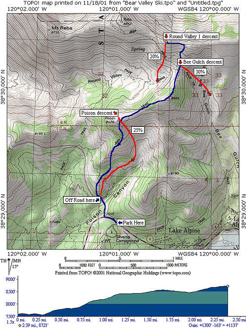
| Trip Map
- Date: January 27, 2001; March 3, 2001; March 10, 2001
- Route: From Sno-Park at end of Highway 4, up Poison Canyon, ending near Mount Reba.
- Total distance: ~4 miles.
|
| 
| |
In the trip reports below, I link to TopoZone.com, but the new tripmap above is an excellent
guide to the places we've skied.
January 27, 2001
With Brad Artman. We started at the end of Bear Valley resort road (Highway 207),
quickly skirting up Poison Canyon. The three days previous had seen a big, powdery
storm, but alas, this day was the day of wind. Nothing falling from the
sky, but an insistent 30 mph north wind blew enough snow to make visibility tough
at times. We climbed to the hill marked with USGS Benchmark
Poison 8420,
for a healthy climb of 900 feet or so in a mile.
Snow conditions were really tough -- 2-3 feet of fresh powder...preserved with a 2-6
inch breakable crust! I wish I had better advice for skiing that stuff, but I don't.
Go fast. Otherwise you'll break through. When you do break through, keep a strong
stance and don't lean too far forward!
March 3, 2001
This trip was the day after a pretty large storm.
We set out in fairly deep (8-16") powder, which rapidly turned to slush in the
morning heat. I've never seen such rapid warming after a storm, but that is California,
my friends! On our ascent of the lower portions of Poison Canyon, Kim and I
found the snow conditions highly unstable on a 30-degree slope. We decided to
cut the day short without earning any turns, but we don't regret it, as the snow
conditions seemed highly unstable.
March 10, 2001
Three times makes a charm! A wonderful, if a bit warm, day. We got a nice early
start (skinning up by 8:30 am), and the snow was an amazingly hard wind pack.
We reached
point 8605'
after a mere 45 minute climb. Near there, we encountered
a large camp (4 tents) of backcountry skiers.
From there, we climbed to the
8730' summit
southeast of benchmark Reba 8842'.
We intended to warm up on the gentle southwest-facing slope, but after our first
run on the rock-hard wind pack, we crossed over the ridge and skied a steep
east-facing slope at the
head of Bee Gulch.
The first run was nice, as the snow
was just starting to loosen. The second run was a bit sketchy, as pseudo-corn
gave way to nasty slush.
We made the easy return to the car after our first successful ski trip to Mount Reba,
and celebrated with a nice lunch in Murphys.
© 2008
, Stanford Exploration Project
Modified: 11/09/08, 20:12:52 PST
, by morgan
Page Maintainer: morgan `AT' sep.stanford.edu