|
| Spatially aliased data |
|
| Spectrum of aliased data |

Seismic data are often insufficiently and irregularly sampled in space because of logistical and/or cost constraints on the data acquisition. The poor spatial sampling causes an incomplete illumination of the reflector that degrades the resolution of the image and may create artifacts. In some situations the artifacts can be avoided by applying well-established safeguards (e.g. antialiased migration) during the imaging process, but at the expenses of image resolution. In others, like the challenges presented by shadow zones in subsalt exploration, present imaging technology is still wanting. The development of solutions to the partial illumination problem is an active area of algorithmic research, and is likely to remain so in the near future. Chapter 9 in 3-D Seismic Imaging discusses the different cases in which poor illumination becomes a problem and presents several research directions that my students and I have explored to address the challenge.
|
|
| Spatially aliased data |
|
|
| Spectrum of aliased data |
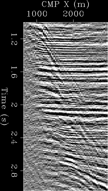
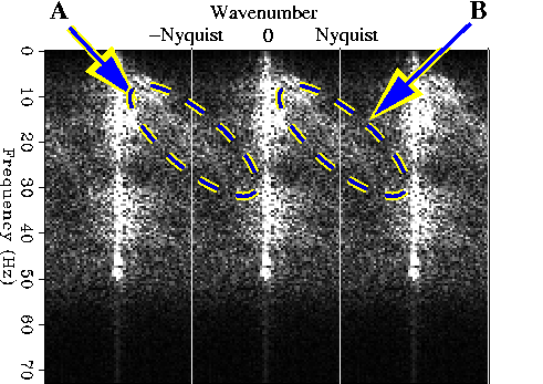
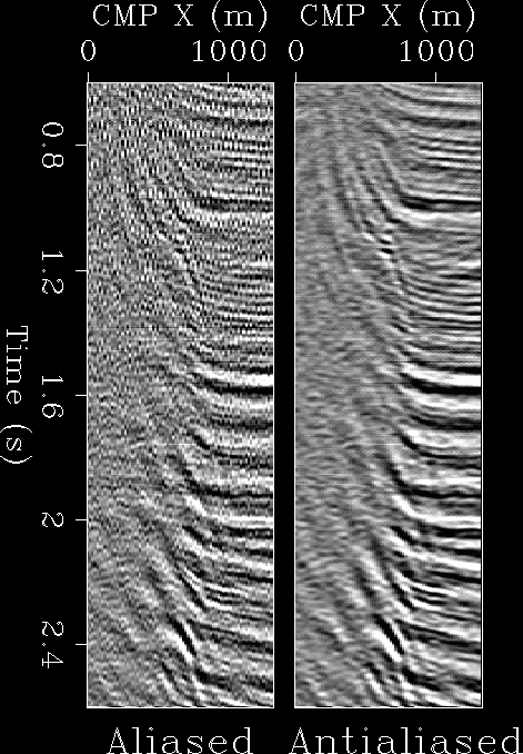
The simplest case of spatial sampling problems are encountered when the data sampling is regular but too sparse; in this cases the data are spatially aliased. The two images on the left illustrate the concept of spatial aliasing of seismic data for a subset of a marine data set recorded in the Gulf of Mexico over a salt diapir. The image on the left shows a window of the data. The flat reflectors are sufficiently sampled, but the salt-flank reflections are clearly aliased. The image in the middle show the Fourier spectrum of the data window on the left. The vertical axis of the spectrum is the temporal frequency and the horizontal axis is the spatial wavenumber. The spectrum is replicated on both sides of the main spatial band to facilitate the visual identification of the aliased energy, which corresponds to the signal energy encircled by the blue-and-yellow ellipses.
|
| Migrated images of aliased data |
3-D prestack data sets are multi offsets; that is, they are acquired with the distance between sources and receivers spanning a wide range from few hundred meters to more than 10 kilometers. Multi-offset data provide redundant illumination of the subsurface reflectors, because different data offsets record events that were reflected with different aperture angle in the subsurface. Near offsets correspond to reflection close to normal incidence, whereas long-offset data correspond to wide-aperture reflections. This data redundancy is routinely exploited for increasing the signal-to-noise ratio of images, as well as for estimating propagation velocity. The simplest way to exploit data redundancy is to average the images obtained from the different subsets (stacking). For example, common-offset cube can be independently imaged, but if each of them is irregularly and insufficiently sampled in space the partial images would be affected by artifacts. These artifacts can be attenuated by stacking and the stacked image is more interpretable than the offset cubes.
However, there are situations in which simple stacking is not sufficient to produce an interpretable image, or, in other cases, the interpretation of the partial images corresponding to different offsets or reflection angle may provide additional information on petrophysical properties of the subsurface, such as in Aperture Versus Offset analysis (AVO). When simple stacking is not sufficient, the redundancy in the data can be exploited by applying advanced data and/or image regularization techniques that are usually based on inversion theory. The routine application of these methods is hampered by their computational and implementation costs, but they are slowly making their way into industrial practices.
The following example shows an application of the data-regularization method presented by Vlad and Biondi (2002) . This method exploits the redundancy in the data domain between offset cubes. It interpolates the recorded data by solving a least-squares inverse problem that maximizes consistency between offset cubes after the application of Normal Moveout (NMO) and Azimuth Moveout (AMO), which make the kinematic of offset cubes consistent with each other. The NMO and AMO operators are discussed in Chapter 3 in 3-D Seismic Imaging.
|
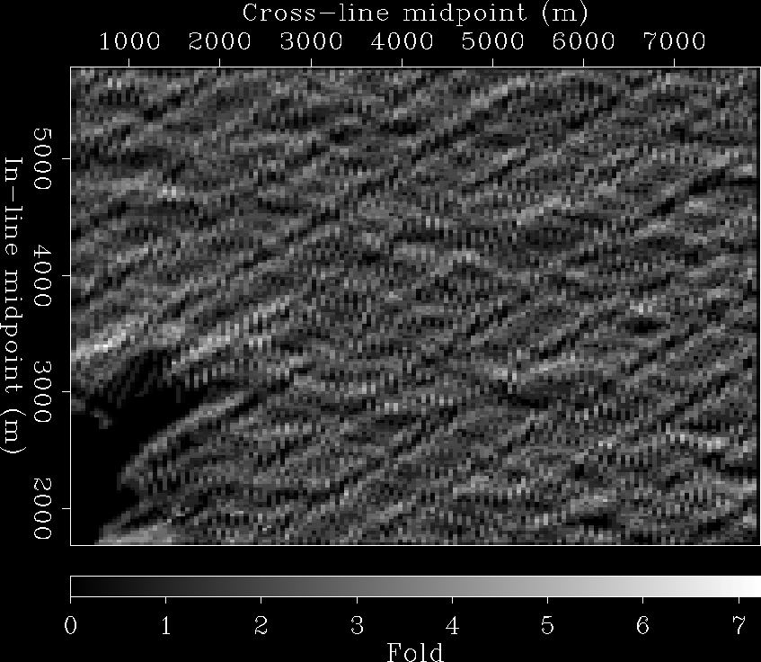
| Density map of a 3-D land data set |
|
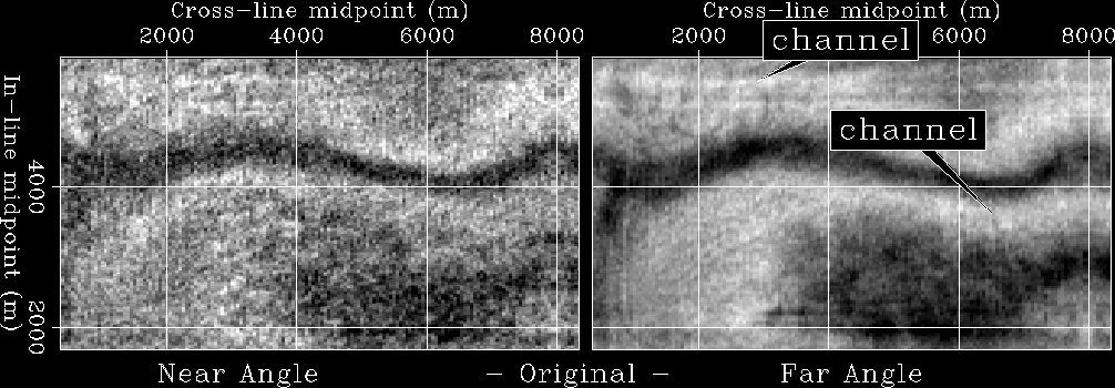
| Migration depth slices before/after data regularization |
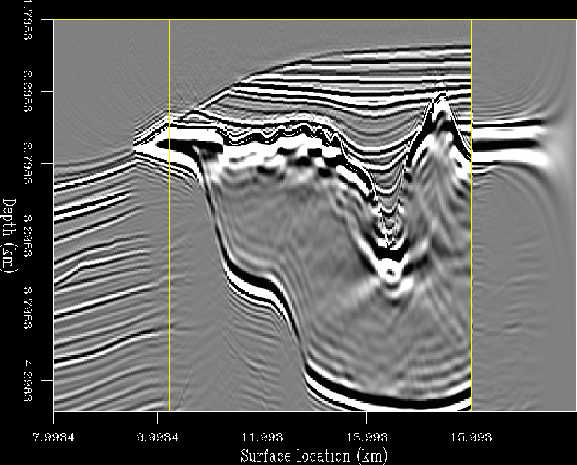
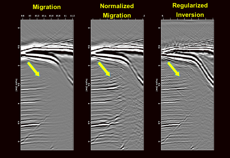
The final example illustrates the most challenging illumination problem; it occurs when the reflectors are poorly illuminated not because of holes in the acquisition geometry, which are known from the data geometry, but because the seismic wavefield is strongly distorted by a complex velocity model, which is not known a priori and cannot be perfectly estimated from the data. In this cases, the migration and velocity estimation problems are tightly intertwined, and it is often impossible to unravel the effects of poor illumination from the effects of velocity errors. Furthermore, to apply inversion-based methods we must perform the regularization in the image space, and we thus must invert an operator that connects the image space with the data space. The application, and consequently the inversion, of such an operator is computationally more demanding than the application of operators defined in the data space by at least one order of magnitude.
The movie on the right demonstrates the effectiveness of the inversion method to reduce imaging artifacts. The left and middle panels show the results of migration (with and without a diagonal normalization factor), whereas the panel on the right show the image obtained by inversion. The movie flips between the images and the velocity model to facilitate the visual connection between the imaged reflectors and the discontinuities in the velocity model that created the reflections. Notice that the regularized inversion not only improves the imaging of ``true'' reflectors (indicated with yellow arrows), but also attenuates ``false'' reflectors (indicated with red arrows) that are coherent in the migrated images and thus could mislead the geological interpretation of the subsalt structure. It is likely that to achieve further improvements in the image we need to introduce additional constraints provided by a geological interpretation of the seismic images. Prucha and Biondi (2002) demonstrated the potential advantages of introducing a a geological regularization in addition to a geophysical regularization. However, the methodology for introducing geological knowledge into seismic imaging is a research area where first-order progress are needed. |