Next: RESERVOIR GEOLOGICAL MODELING
Up: Geophysics-PE: Reservoir monitoring
Previous: INTRODUCTION
Reservoir monitoring by repeated seismic surveys is based on the
assumption that changes in fluid properties cause detectable changes in the
recorded seismic data. For an individual reservoir under study the validity
of this assumption depends on many factors, such as lithology, fluid
properties, production history, and seismic data quality. To analyze the
influence that all these factors have on the potential success of seismic
monitoring, we developed numerical tools for modeling all the relevant
physical processes involved in reservoir monitoring and linked them in a
unified modeling flow.
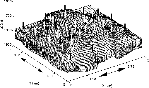
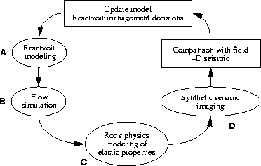
The starting point of our project was building a reservoir model, shown in
Figure ![[*]](http://sepwww.stanford.edu/latex2html/cross_ref_motif.gif) ,
whose lithology and structure resembles a North Sea reservoir.
We then simulated the multiphase fluid flow and production history of the
reservoir over a period of 3 years. We estimated the effective seismic
properties of the reservoir combining the lithologic model and the fluid
properties. Finally, we simulated multi-offset 3-D seismic surveys at
different times during the production history. This process is shown as
Steps A-D in Figure .
,
whose lithology and structure resembles a North Sea reservoir.
We then simulated the multiphase fluid flow and production history of the
reservoir over a period of 3 years. We estimated the effective seismic
properties of the reservoir combining the lithologic model and the fluid
properties. Finally, we simulated multi-offset 3-D seismic surveys at
different times during the production history. This process is shown as
Steps A-D in Figure .
meshbw
Figure 1 Perspective view of the reservoir model, showing structure and faults.
The reservoir lithology was fashioned after braided stream fluvial
reservoirs common in many parts of the world including the North Sea.
Production wells are indicated in white, and water injection wells are
indicated in black. Arrows and ticks along the X and Y axes show extent
of seismic imaging.
 flow
flow
Figure 2
Steps involved in monitoring reservoir performance.
While the macro-scale of our model reservoir is
constant ( km)
the sampling of the reservoir physical parameters varies greatly
between steps. The main scales that we used are described below:
km)
the sampling of the reservoir physical parameters varies greatly
between steps. The main scales that we used are described below:
- Core Scale
- is about
 m.
Much of what is known
about rock physics relations among rock, fluid, and seismic properties
has come from measurements at the core scale. Description of the complete
reservoir at this
scale would yield 1013 (10,000 billion) voxels and is not
practical. Nevertheless, in any reservoir, a subset of core data can yield
seismic-to-reservoir properties relations that are critical
to the seismic modeling.
m.
Much of what is known
about rock physics relations among rock, fluid, and seismic properties
has come from measurements at the core scale. Description of the complete
reservoir at this
scale would yield 1013 (10,000 billion) voxels and is not
practical. Nevertheless, in any reservoir, a subset of core data can yield
seismic-to-reservoir properties relations that are critical
to the seismic modeling.
- Reservoir Geological Modeling Scale
- is nominally
 m.
Ideally, the geological model would be at the resolution of the best
information, i.e., the core data. This is not practical and, instead,
a scale is chosen small enough to capture the significant geological
heterogeneities and large enough to yield a tractable number of cells
or voxels. The scale chosen here yields 200 million voxels which is
ambitious but practical for reservoir modeling. There are about 50,000
core scale voxels within a geological modeling cell.
m.
Ideally, the geological model would be at the resolution of the best
information, i.e., the core data. This is not practical and, instead,
a scale is chosen small enough to capture the significant geological
heterogeneities and large enough to yield a tractable number of cells
or voxels. The scale chosen here yields 200 million voxels which is
ambitious but practical for reservoir modeling. There are about 50,000
core scale voxels within a geological modeling cell.
- Reservoir Flow Simulation Scale
- The scale of the grid blocks in fluid flow simulation is a compromise
between the desire to minimize artificial numerical artifacts,
accounting for sufficient geological detail, and available computational
resources. Full-field simulation, requiring order 102 grid blocks
between wells can easily lead to systems with 106-108 grid blocks, which
remains well beyond current computational possibilities.
In this study, a discretization of the macro-scale into
nx=132
 ny=140 nz=12 resulted in grid blocks with
an areal scale of
ny=140 nz=12 resulted in grid blocks with
an areal scale of  m in the coarse region
and
m in the coarse region
and  m in the refined region.
The vertical size of the grid blocks, on average, was 8.3 m.
m in the refined region.
The vertical size of the grid blocks, on average, was 8.3 m.
- Seismic Imaging Scale
- is the scale of the resolution of the
seismic images, that is linked with the wavelength
of the seismic signal recorded at the surface
(
 m in our model).
We described the seismic properties of the reservoir
on a
m in our model).
We described the seismic properties of the reservoir
on a  meters scale.
Description at this scale of the whole reservoir would yield
about 50 million voxels.
We have used a subset of the whole reservoir,
for a total of about 1.5 million voxels.
meters scale.
Description at this scale of the whole reservoir would yield
about 50 million voxels.
We have used a subset of the whole reservoir,
for a total of about 1.5 million voxels.
Next: RESERVOIR GEOLOGICAL MODELING
Up: Geophysics-PE: Reservoir monitoring
Previous: INTRODUCTION
Stanford Exploration Project
11/12/1997