


![[*]](http://sepwww.stanford.edu/latex2html/cross_ref_motif.gif) is a map of the Norwegian oil infrastructure
around the Valhall reservoir between the coasts of England and Norway
showing the many developments in the region. It is 630 km from the
Southern tip of the Norway shown and the city of Teeside in England.
is a map of the Norwegian oil infrastructure
around the Valhall reservoir between the coasts of England and Norway
showing the many developments in the region. It is 630 km from the
Southern tip of the Norway shown and the city of Teeside in England.
|
areamap
Figure 1 English, Norwegian, and Danish coasts surrounding the North Sea oil development area. The Valhall reservoir is in the South-central area of the map and only 20 km from English-controlled waters to the West, and Danish waters to the South. | 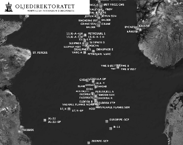 |

There are five surface structures (roughly over the center of the
reservoir), and two wellhead platforms at the North and South ends of
the NW-SE elongate elliptical reservoir (both roughly 6 km from the
central platforms). The main fluid export pipeline runs NNW to the
Ekofisk reservoir, about 30 km distant. Figure shows
the location of the 13 lines of OBC 4C geophones installed in the
summer of 2003. The +10,000 sensors are permanently installed on the
sea floor, in roughly 70 m of water, forming a roughly 5 by 10 km
rectangle. Nominal in-line spacing of receiver stations is 50 m,
while the cross-line separation is 300 m.
|
actg
Figure 2 Valhall permanent subsea geophone array. Each station measures 4 components (4C) of the seismic wavefield: Pressure with a piezoelectric sensor, and three orthogonal velocities of ground displacement with coil-spring geophones. | 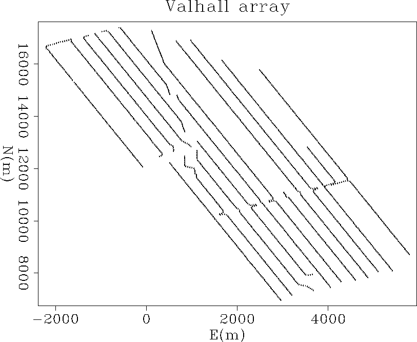 |
Approximately half-way down the North axis of Figure ,
the cables on the Western side of the array are truncated. This is
where the production facilities are located to which the instruments
are telemetered. Also noticeable is the deviation of the ends of
cables on the North side of lines 5-7 (E=1000m) to the NNW. This is
the corridor for the export lines to Ekofisk. Production facilities are
continuously manned and operated, to include: Over 150 total well-bores
into the reservoir section, current production of approximately 80,000
b/d oil and gas from 43 wells, water injection through (at least) 3
wells, generation of almost 80 MW of electrical power with gas
turbines, export lines and the continual presence of multiple modes of
transportation![[*]](http://sepwww.stanford.edu/latex2html/foot_motif.gif) . Valhall is located in a
heavily developed area, within kilometers of developments in the
English and Norwegian controlled waters and is about half-way between
the two countries. Also important to the chalk oil trend of this part
of the North Sea is the rate of subsidence associated with pressure
withdraw during production. In its first 15 years of production (to
1997), the sea-floor subsided 3.5 meters at the crest of the reservoir
structure Gebara et al. (2000).
. Valhall is located in a
heavily developed area, within kilometers of developments in the
English and Norwegian controlled waters and is about half-way between
the two countries. Also important to the chalk oil trend of this part
of the North Sea is the rate of subsidence associated with pressure
withdraw during production. In its first 15 years of production (to
1997), the sea-floor subsided 3.5 meters at the crest of the reservoir
structure Gebara et al. (2000).