


This section briefly describes the wave-equation migration from
topography (TopoWEM) approach presented in
Shragge and Sava (2004). Two theoretical developments are
central to the technique: i) generating an orthogonal grid conformal
with the acquisition surface using a conformal mapping approach; and
ii) adapting wave-propagation physics to be consistent with the
geometry of the computational mesh using Riemannian wavefield
extrapolation (RWE) Sava and Fomel (2005). Conformal mapping
transforms can be manipulated to generate an orthogonal coordinate
system by computing a mapping from a topographically influenced domain
to a rectangular mesh (c.f. Figure ![[*]](http://sepwww.stanford.edu/latex2html/cross_ref_motif.gif) ). First, the image
of the boundary points in the physical domain (upper left) is found in
the canonical domain (upper right) through composite mapping
). First, the image
of the boundary points in the physical domain (upper left) is found in
the canonical domain (upper right) through composite mapping ![]() (where g and f-1 represent mappings from the physical
domain to the unit circle and from the unit circle to a rectangle,
respectively). A uniform mesh, specified in the canonical domain
(lower right), is then mapped to the physical domain (bottom left)
using the inverse relation
(where g and f-1 represent mappings from the physical
domain to the unit circle and from the unit circle to a rectangle,
respectively). A uniform mesh, specified in the canonical domain
(lower right), is then mapped to the physical domain (bottom left)
using the inverse relation ![]() , creating an orthogonal
mesh conformal to the topographic surface.
, creating an orthogonal
mesh conformal to the topographic surface.
|
map1
Figure 1 Cartoon showing the conformal mapping transform between topographic and rectangular domains. Top left: topographic domain with data acquisition points; Top right: domain boundary in top left mapped to a rectangular domain under mapping | 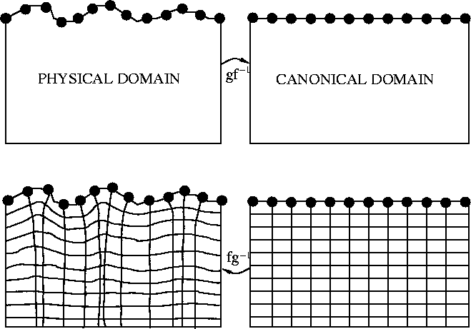 |

The second step is to specify the RWE extrapolation equations appropriate for the generated topographic coordinate system. This approach specifies a wave-equation dispersion appropriate for one-way wavefield extrapolation in generalized coordinate systems. Shragge and Sava (2004) discusses how to perform wave-equation migration directly from topographic coordinate systems, and illustrates this approach with a synthetic 2D data example.