Next: Geological RIP
Up: 2-D results
Previous: 2-D results
As described in the previous chapter, the regularization operator
used for geophysical RIP acts along the offset ray parameter axis.
To set the strength of regularization (see the fitting goals
(![[*]](http://sepwww.stanford.edu/latex2html/cross_ref_motif.gif) )) for this real data example, I
chose 73#73 by trial and error. I performed 6 iterations
which was chosen based on data space residuals, as
will be explained later. The result can be seen in Figures
through . In each of these, the migration result is
displayed above the geophysical RIP result. Both show a common ray parameter
section on the left and a common image gather (CIG) on the right. The vertical
lines indicate which CRP location and offset ray parameter value the
panels are taken from. The effect
of the regularization is clearest in the CIGs. The
common ray parameter sections also show the effects. All of these
results show a crisper image after RIP, with fewer artifacts. To see the
improvements more clearly, I have zoomed in on the area beneath the salt in
Figures through .
)) for this real data example, I
chose 73#73 by trial and error. I performed 6 iterations
which was chosen based on data space residuals, as
will be explained later. The result can be seen in Figures
through . In each of these, the migration result is
displayed above the geophysical RIP result. Both show a common ray parameter
section on the left and a common image gather (CIG) on the right. The vertical
lines indicate which CRP location and offset ray parameter value the
panels are taken from. The effect
of the regularization is clearest in the CIGs. The
common ray parameter sections also show the effects. All of these
results show a crisper image after RIP, with fewer artifacts. To see the
improvements more clearly, I have zoomed in on the area beneath the salt in
Figures through .
bp2d.1
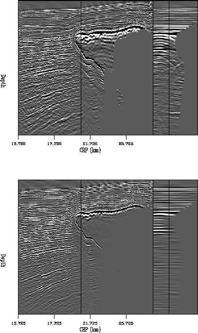
Figure 2 Top: result of downward-continuation migration
of 2-D line. Left part is a common offset ray parameter section at
74#74,right part is a common image gather from 75#75.
Bottom: result of 6 iterations of
geophysical RIP.
![[*]](http://sepwww.stanford.edu/latex2html/movie.gif)


 bp2d.4
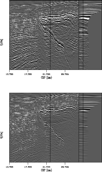
Figure 3 Top: result of downward-continuation migration
of 2-D line. Left part is a common offset ray parameter section at
76#76,right part is a common image gather from 77#77.
Bottom: result of 6 iterations of
geophysical RIP.
bp2d.3
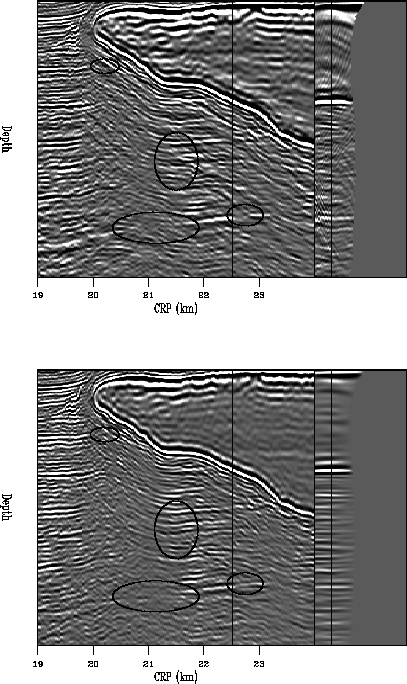
Figure 4 Top: result of downward-continuation migration
of 2-D line. Left part is a common offset ray parameter section at
78#78,right part is a common image gather from 79#79. Bottom: result of
6 iterations of geophysical RIP.
bp2d.2
Figure 5 Top: result of downward-continuation migration
of 2-D line. Left part is a common offset ray parameter section at
74#74,right part is a common image gather from 80#80. Bottom: result of
6 iterations of geophysical RIP.
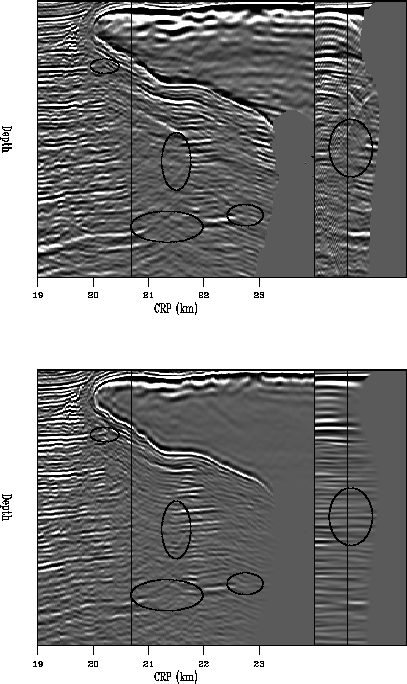
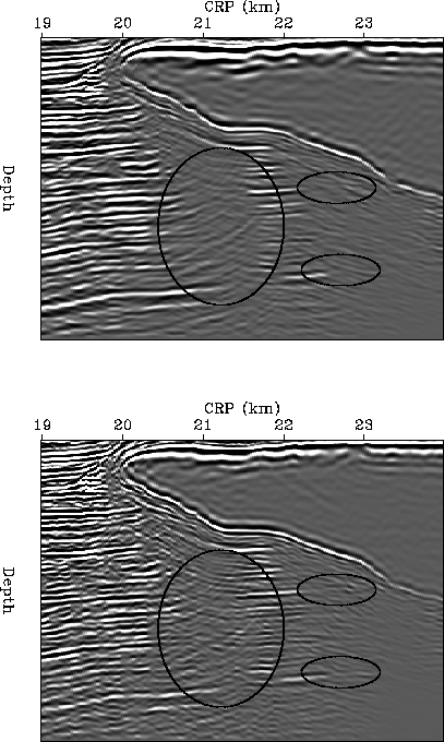
In Figures through , the same ovals
are shown on the migration result (top) and the geophysical RIP result
(bottom). Figures and have particularly
clear examples
of the holes in the common image gather being filled. The whole common
ray parameter section is cleaner than the one from the migration result. The
subsalt reflectors are extending into the shadow zones everywhere, particularly
in the areas indicated by the ovals. Geophysical RIP produces a cleaner
result with better illumination than migration.
zbp2d.1
Figure 6 Zoomed portion of Figure .
Top: result of downward-continuation migration
of 2-D line. Left part is a common offset ray parameter section at
74#74,right part is a common image gather from 75#75.
Bottom: result of 6 iterations of geophysical RIP. Ovals indicate areas
where poor illumination exists in the migration result and is improved
in the RIP result.
zbp2d.4
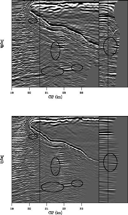
Figure 7 Zoomed portion of Figure .
Top: result of downward-continuation migration
of 2-D line. Left part is a common offset ray parameter section at
76#76,right part is a common image gather from 77#77.
Bottom: result of 6 iterations of geophysical RIP. Ovals indicate areas
where poor illumination exists in the migration result and is improved
in the RIP result.
zbp2d.3
Figure 8 Zoomed portion of Figure .
Top: result of downward-continuation migration
of 2-D line. Left part is a common offset ray parameter section at
78#78,right part is a common image gather from 79#79.
Bottom: result of 6 iterations of geophysical RIP. Ovals indicate areas
where poor illumination exists in the migration result and is improved
in the RIP result.
zbp2d.2
Figure 9 Zoomed portion of Figure .
Top: result of downward-continuation migration
of 2-D line. Left part is a common offset ray parameter section at
74#74,right part is a common image gather from 80#80.
Bottom: result of 6 iterations of geophysical RIP. Ovals indicate areas
where poor illumination exists in the migration result and is improved
in the RIP result.
It is also interesting to stack (sum along the offset ray parameter axis)
the results (Figure ).
Once again, the stack of the migration result is shown on top and the
stack of the result after 6 iterations of geophysical RIP is on the bottom.
The ovals indicate where the reflectors extend farther into the shadow
zones. In the RIP result, some reflectors can be seen almost all the way
through the poorly illuminated areas. Also, the artifacts
seen in the stack of the migration result are reduced in the RIP result.
zstackbp2d
Figure 10 Top: stack of the result of
downward-continuation migration
of 2-D line. Bottom: stack of the result of 6 iterations of
geophysical RIP. Ovals indicate areas where poor illumination exists in
the migration result and is improved in the RIP result.
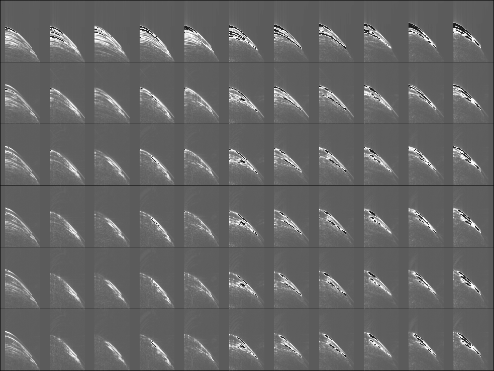
As mentioned earlier, I chose to display the RIP results after 6 iterations
based on an examination of the data space residuals as the least-squares
inversion was performed. The data space residuals for each iteration can be
seen in Figure . Each row is a collection of CMP gathers
taken from locations across the whole survey. I have taken the envelope of
the energy and clipped the high values, which appear as solid black regions.
The first row is the original
data, the second row shows the same CMP gathers after 2 iterations,
the third row is after 4 iterations, fourth row after 6 iterations,
fifth row after 8 iterations and sixth after 10 iterations. The
salt body begins at a CMP location between the fifth and sixth gathers
shown.
The biggest change in the residual energy occurs within the first two
iterations, as would be expected. We see that the residual energy
away from the salt decreases quickly (the black areas decrease). The
residual energy associated with
the salt also decreases, with the exception of energy beginning around
3.75 seconds that is caused by converted waves that my acoustic code
cannot properly handle. The small change in residual energy between
the sixth and tenth iterations indicates that the inversion is nearing
convergence. Therefore, we expect very little change in the image after
6 iterations.
comp.resid
Figure 11 Comparison of the data space residuals
from RIP with geophysical regularization. The vertical axis is time, the
horizontal axis is offset. Each row is a collection of CMP
gathers taken from locations across the whole survey, taking the envelope
of the energy and clipping the high values (indicated by black). The
first row is the original
data, the second row shows the same CMP gathers after 2 iterations,
the third row is after 4 iterations, fourth row after 6 iterations,
fifth row after 8 iterations and sixth after 10 iterations.
Next: Geological RIP
Up: 2-D results
Previous: 2-D results
Stanford Exploration Project
10/31/2005