


Today's world is still quite far from overcoming its dependence on hydrocarbons. Unfortunately, finding hydrocarbons is getting more and more difficult. They are no longer found by simply looking for surface anticlines. We now look for hydrocarbons deep within the earth in stratigraphic or structural traps (). In this thesis, I am concerned with improving our ability to create images of complex structural traps using seismic data.
A good location for a structural trap is at the edges of salt
bodies in the subsurface. These salt bodies are often found
under deep water, making it economically unfeasible to just
drop a well (wildcatting). Therefore, we want to image the subsurface
surrounding the salt as well as possible. Unfortunately,
salt has a very high seismic velocity (often twice as high as the surrounding
subsurface) that significantly
reduces the amount of seismic energy that gets through to the
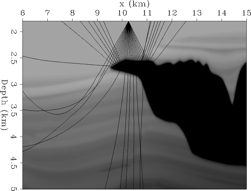
surrounding rock (Figure ![[*]](http://sepwww.stanford.edu/latex2html/cross_ref_motif.gif) , seismic energy is represented by
rays). This energy may be directed outside of the bounds of the seismic survey
(Figure ), or become
evanescent (die out) at the salt boundaries. This poor illumination makes
it very difficult to image the potential hydrocarbon traps.
, seismic energy is represented by
rays). This energy may be directed outside of the bounds of the seismic survey
(Figure ), or become
evanescent (die out) at the salt boundaries. This poor illumination makes
it very difficult to image the potential hydrocarbon traps.
 |


 |
Imaging the subsurface is commonly done with some type of migration.
Migration tries to move the seismic energy recorded at the earth's surface
back to where it belongs in the subsurface, thereby
creating an image of the subsurface. Poor illumination will cause
``shadow zones'' in the resulting image, in the areas where we hope to
find the potential hydrocarbon traps. These shadow zones are clear
in Figure , which shows
the result of trying to migrate the seismic data collected over the
subsurface shown in Figure . Shadow zones often contain
some seismic signal that may be recovered with better imaging techniques.
However, some of the information we would need to fill in these areas does
not exist in the data at all.
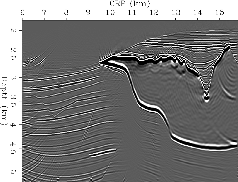 |
. The events
seen clearly on the left side of the image die out as they go beneath
the salt. These are the shadow zones.