


The first test of the approach is on a 2D synthetic model
characterized by rugged topography. This model is a merger of common
geologic features from the Canadian Foothills in northeastern
British Columbia, Canada Gray and Marfurt (1995). The velocity model, shown in
Figure ![[*]](http://sepwww.stanford.edu/latex2html/cross_ref_motif.gif) , consists of steep thrust fault planes
and complex folds typical of a mountainous thrust region.
, consists of steep thrust fault planes
and complex folds typical of a mountainous thrust region.
|
Foothills.vel
Figure 2 Example of 2D topography from the Canadian Foothills. Topographic surface is the first break in gray tone from the surface. |  |


The topographic boundary of interest is demarcated by the velocity model discontinuity nearest to the surface. The total relief of the model's surface is approximately 1600 m.
Figure shows the test results. The flat datum
surface is at a depth of 10000 m. Left-hand panels
show the case where surface topography amplitudes are scaled down
by 50![]() .
.
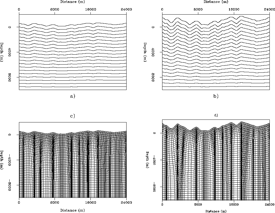 |
The top left panel shows the 2-D potential function obtained through solution of Equation (5). The PF is rougher nearer the surface, but smooths out to become uniform at the lower domain boundary. The bottom left panel shows the coordinate system ray-traced from the PF presented in the top left panel. Note that the coordinate system focuses beneath topographic maxima, and defocuses under topographic minima. This demands that the Jacobian value in Equation (7) diverge from unity.
The right-hand panels of Figure show results similar
to those in the left-hand panels, except that the true topographic
surface is restored. The top right panel shows a rougher PF, which is
expected due to the increased topographic rugosity. The bottom right
panel presents the coordinate system ray-traced from the PF shown in
the upper right panel. Relative to that the bottom left panel, this
coordinate system exhibits increased focusing and defocusing under
topographic maxima and minima, respectively.