


![[*]](http://sepwww.stanford.edu/latex2html/cross_ref_motif.gif) ). If for each point in the
z-plane domain there corresponds a unique number in the w-plane,
then the mapping function is analytic. In addition, if for each point
in the w-plane there corresponds precisely one point in the
z-plane, then the mapping is one-to-one and the transformation is
invertible. The Cauchy-Riemann equations Nehari (1975) are the
necessary and sufficient conditions for function f(z) to be analytic
in a domain of interest.
). If for each point in the
z-plane domain there corresponds a unique number in the w-plane,
then the mapping function is analytic. In addition, if for each point
in the w-plane there corresponds precisely one point in the
z-plane, then the mapping is one-to-one and the transformation is
invertible. The Cauchy-Riemann equations Nehari (1975) are the
necessary and sufficient conditions for function f(z) to be analytic
in a domain of interest.
 |

A conformal map is distinguishable from other mappings between complex planes by characteristic properties. Most important to this discussion is the following property:
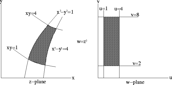
illustrates the property that grid lines
orthogonal in the w-plane are orthogonal in the z-plane under a
conformal map. By extension, non-Cartesian orthogonal coordinate
systems can be created in the z-plane (or conversely in the
w-plane) by a conformal mapping of a rectangular coordinate system
in the w-plane (z-plane).
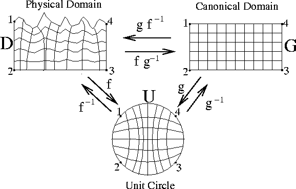
The first major developments in the theory of conformal mapping originated with the mapping theorem of Riemann (1851), who proved the existence of a unique analytic mapping between any two simply-connected, analytic domains:
Figure illustrates the Riemann mapping
theorem between three domains pertinent to the current discussion.
Figure presents an example of a conformal mapping
between a square and unit circule (the mapping g in
Figure ).
 |
We will use the Riemann mapping theorem to transform the topographic
domain to a rectangular computational mesh. Assisting us is an extensive
catalog of conformal maps between common geometrical domains.
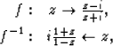
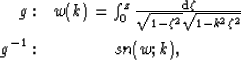
Pertinent to the current discussion are the conformal maps between the
unit circle (UC) and the upper half plane (UHP), ![]() and its inverse
and its inverse ![]() ,
,
 |
(1) | |
 |
(2) | |
|
confexamp
Figure 3 Conformal mapping between a square coordinate system and the unit circle. | 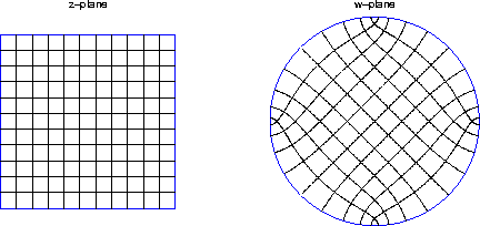 |
Table 1 outlines a work flow to generate a topographic coordinate system through conformal mapping. The first step is to define the enclosure of the physical domain where the topographic surface defines the upper boundary. We create the lower boundary by mirroring the topography at twice the maximum extrapolation depth. The side boundaries are defined by straight lines that join the top and bottom segments. We denote the border points ztopobnd, where subscript topo and superscript bnd refer to topography and boundary points, respectively. The four corner points of the physical domain are also specified. The next two steps involve calculating the forward and inverse mapping functions, f and f-1, between the topographic surface and the unit circle. The fourth step is to generate a rectilinear boundary and to define its four corner points. We denote this boundary zrectbnd, where subscript rect refers to rectangle. The next two steps involve calculating forward and inverse mappings functions, g and g-1, between the boundary of the rectangle and the unit circle.
To discern where in the canonical domain to form the coordinate system
grid, we need to find the mapping of the topography boundary points on
the rectangular domain boundary. This is accomplished by calculating the
image of the boundary points under composite mapping operations,
![]() . A rectangular grid is
then set up at the image points to create computational grid,
zrectcs, where superscripts cs denote coordinate
system.
. A rectangular grid is
then set up at the image points to create computational grid,
zrectcs, where superscripts cs denote coordinate
system.
Table 1. Work flow to calculate topographic coordinates with conformal mapping.
| Step | Description | Notation |
| 1 | Define physical domain boundary and 4 corner points | ztopobnd |
| 2 | Calculate mapping |
wtopobnd=f(ztopobnd) |
| 3 | Calculate mapping |
ztopobnd=f-1(wtopobnd) |
| 4 | Define canonical domain border and 4 corner points | zrectbnd |
| 5 | Calculate mapping |
wrectbnd=g(zrectbnd) |
| 6 | Calculate mapping |
zrectbnd=g-1(wrectbnd) |
| 7 | Find image of topography in the rectangle | zimbnd=g-1(f(ztopobnd)) |
| 8 | Construct rectilinear grid using zimbnd(ztopobnd) | zrectcs |
| 9 | Map grid zrectcs to physical domain | ztopocs=f-1(g(zrectcs)) |
The final step is to map the rectilinear coordinate system,
zrectcs, from the canonical domain back to the topographic
coordinates under composite mapping operation, ![]() . Point set ztopocs defines a
coordinate system appropriate for performing wavefield continuation
directly from topography at the acquisition locations. The next
section details how this point set is used to generate the appropriate
extrapolation equations.
. Point set ztopocs defines a
coordinate system appropriate for performing wavefield continuation
directly from topography at the acquisition locations. The next
section details how this point set is used to generate the appropriate
extrapolation equations.