


In order to help with such tasks, a process called ``coherency evaluation'' has been developed Bahorich and Farmer (1995); Marfurt et al. (1998). The coherency evaluation calculates continuity of seismic events from a 3D seismic image cube and produces a so-called ``coherency cube'' that shows the distribution of the event continuity in a 3D volume. The output of coherency evaluation processing helps the interpreters to locate geologically meaningful discontuinities more easily. However, interpreting and mapping 3D discontinuity surfaces by hand is still a challenging job because of the difficulty in visualizing a 3D image and the complexity of surfaces in a 3D sense.
As a supplementary tool for mapping discontinuities, I introduce an automatic discontinuity extraction method. The proposed method starts with a coherency evaluation for a 3D seismic image and produces a discontinuity map that locates the event's discontinuities in the form of arbitarily shaped 3D surfaces. The output of the proposed method could be a good starting point for an interpreter to narrow down the various discontinuities into more meaningful geological features such as faults, unconformities, and buried channels.
In the following section I will shortly review the coherency evaluation method
to clarify the meaning of a discontinuity in a seismic image.
The subsequent two sections are devoted to explaining the following procedures.
In each step, the algorithm is explained and also demonstrated
with a real seismic image.
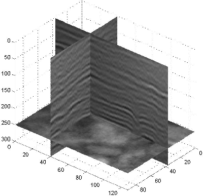
The testing image used is from the Boonsville natural gas field
located in north-central Texas
and was acquired by the DOE and the Gas Research Institute
as part of a secondary gas recovery technique development.
According to Hardage Hardage (1996),
the Boonsville seismic image is a full-fold time migrated section
with ![]() in bin size and covers 5.5 km2 area.
The data consists of 97 lines along the crossline and each line has
113 traces. Figure 1 shows three plane sections
of the image volume which are orthogonal to each other.
in bin size and covers 5.5 km2 area.
The data consists of 97 lines along the crossline and each line has
113 traces. Figure 1 shows three plane sections
of the image volume which are orthogonal to each other.
 |
